PIN-Main Radar Site
Canada /
Northwest Territories /
Norman Wells /
World
/ Canada
/ Northwest Territories
/ Norman Wells
World / Canada / Northwest Territories / Inuvik
military, early warning radar

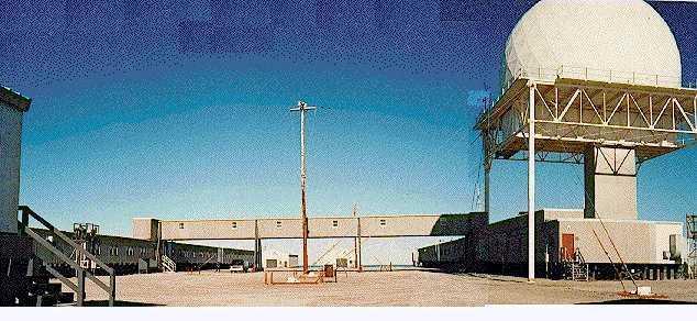
Established and declared operational in 1957 following several years of construction, the PIN-Main or Cape Parry radar site operated as a Main or Sector Headquarters station for the PIN Sector of the DEW Line. Spanning some 2,607 acres and equipped with a large airfield, large seaside beaching area and expansive dormitory facilities, PIN-Main operated not only as a major radar site, but also as the primary logistical hub for material and main transfer point for personnel moving between PIN sector stations stretching Eastward to Cape Peel in Nunavut. Often busiest during the during the brief summer months, the station would oversee round-the-clock air operations as sealift resupply convoys flooded supplies and personnel into the station for distribution throughout the sector.
From 1957 through 1963, the site also operated as one of four Rearward/Vertical Communications sites built to receive and relay surveillance data from the DEW Line to military authorities in the United States and Canada via RCAF Station Stoney Mountain (WAT-X). This task was accomplished by the use of the IS-101 Ionoscatter Radio system, also known as the AN/FRC-101, which carried data teletype transmissions over the 1,000+ mile distance between the stations.
Operating through the end of the DEW Line in August of 1989, PIN-Main's facilities were reused for the housing of AN/FPS-117 long-range radar system as the facility became part of the North Warning System. Serving in the same NWS role as it did with the DEW Line, PIN-Main remains the primary logistics support base for the North Warning System stations roughly half of the PIN and BAR sectors, and is manned continuously by approximately 15 personnel who conduct regular deployments to the outlying stations for maintenance and resupply during the summer months.
lswilson.dewlineadventures.com/pin-main.htm
Wikipedia article: http://en.wikipedia.org/wiki/North_Warning_System
Nearby cities:
Coordinates: 70°9'54"N 124°41'44"W
- Former PIN-3 DEW Line Radar Site 486 km
- Former PIN-4 DEW Line Radar Site 626 km
- Former CAM-Main DEW Line Radar Site 763 km
- Brunt Mountain 854 km
- Former POW-1 DEW Line Radar Site 1053 km
- Former CAM-2 DEW Line Radar Site 1055 km
- Former CAM-C DEW Line Radar Site & Airfield 1143 km
- North Salt Lagoon 1166 km
- Former LIZ-C DEW Line Radar Site 1234 km
- Cape Hawaii 1908 km
- Horton River Delta 84 km
- MacKenzie Lake 92 km
- Smoking Hills 92 km
- Franklin Bay 96 km
- Thrasher lake 102 km
- Harrowby Bay 119 km
- Cape Bathurst 132 km
- Baillie Island 140 km
- Luemat Lake 170 km
- Tadenet Lake 179 km
Comments