Holy Cross (New Orleans, Louisiana)
USA /
Louisiana /
Arabi /
New Orleans, Louisiana
World
/ USA
/ Louisiana
/ Arabi
World / United States / Louisiana
region, NRHP - National Register of Historic Places, residential neighbourhood
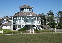
One New Orleans historic district is struggling to become the nations first carbon-neutral neighborhood. Help New Orleans Holy Cross Neighborhood in their recovery and rebuilding efforts. In the days immediately following Hurricane Katrina in August 2005, this neighborhood in New Orleans' Lower Ninth Ward became submerged in 10 feet of water for three weeks following a massive levee break nearby. Although fewer than 20% of the residents have been able to return to their homes nearly 2 years after the hurricane and flooding, Holy Cross hopes to become a sustainable, energy independent community of the future and a shining example for the nation as a whole.
Wikipedia article: http://en.wikipedia.org/wiki/Holy_Cross,_New_Orleans
Nearby cities:
Coordinates: 29°57'23"N 90°1'1"W
- South Lafourche 55 km
- Barbers Hill 479 km
- Clear Creek 506 km
- Memorial 536 km
- Houston Energy Corridor 548 km
- San Bernard National Wildlife Refuge 552 km
- Bridgeland 558 km
- Laguna Atascosa National Wildlife Refuge 827 km
- LANWR-Redhead Ridge Unit 841 km
- Salinas Victoria 1110 km
- Lower Ninth Ward 1.4 km
- Arabi, Louisiana 1.9 km
- Bywater 2.5 km
- St. Claude 2.9 km
- Algiers Point 3.1 km
- New Orleans Container Terminal France Road (defunct) 3.7 km
- Algiers 3.8 km
- Industrial Canal (IHNC) 4.3 km
- Gentilly 7 km
- Bayou Bienvenue 8.5 km