Lake Beseka
Ethiopia /
Oromia /
Metehara /
World
/ Ethiopia
/ Oromia
/ Metehara
World / Ethiopia / Oromia / East Shewa
lake
Add category
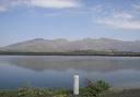


Lake Beseka lies in the Upper Awash Basin, to the immediate south of the Awash National Park, at an altitude of 954 meters (3,130 feet) above sea level, some 178 kilometers (111 miles) east of Addis.
The Lake is about 10 km (6 miles) long, and is up to 6 km (4 miles) wide. It has the surface area of approximately 45 km² (17 mi²).
The Lake is about 10 km (6 miles) long, and is up to 6 km (4 miles) wide. It has the surface area of approximately 45 km² (17 mi²).
Nearby cities:
Coordinates: 8°52'39"N 39°52'15"E
- Lake Ziway 152 km
- Lake Shala 221 km
- Lake Fincha 313 km
- Lake Abbe 332 km
- Lake Abaya 356 km
- Lake Chamo 419 km
- Chew Bahir 573 km
- Grand Ethiopian Renaissance Reservoir 596 km
- Lake Turkana 660 km
- Lake Bisina 1040 km
- Metehara sugar cane Farm & Factory 10 km
- Caldera 13 km
- Mount Fentale 13 km
- Beru volcano 15 km
- Awash National Park 19 km
- Kone Caldera (Gariboldi Caldera) 20 km
- Kone volcanic complex 23 km
- Kuyu Korebta 25 km
- Bericha Volcano 47 km
- Boset-Bericha Volcano 54 km
Comments