Lake Shala
Ethiopia /
Oromia /
Negele /
World
/ Ethiopia
/ Oromia
/ Negele
World / Ethiopia / Oromia / East Shewa
lake, caldera
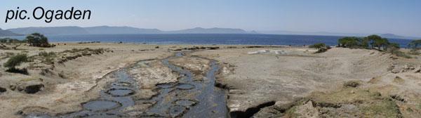


Lake Shala, the deepest, most voluminous lake in Ethiopia, is set at an altitude of 1,559 meters (5,115 feet), in the Main Ethiopian Rift (MER), about 225 kilometers (140 miles) south of Addis Ababa.
The lake is 27km (17 miles) long, and is up to 16km (10 miles) wide. With the surface area of 314 km² (121 mi²), it has a maximum depth of 266 meters (873 feet), and a mean depth of 86m (282 feet). It's estimated to contain 38 billion m³ (1.34 trillion ft³) of water, the amount much larger than that of Lakes, Tanan, Ziway, Abyata, Langano and Awassa combined.
Lake Shala, along with its northerly neighbor, Lake Abyata form part of the Abyata-Shala National Park.
en.wikipedia.org/wiki/Main_Ethiopian_Rift
en.wikipedia.org/wiki/O%27a_Caldera
Reference: National Atlas of Ethiopia, 1988.
Measurement tools provided by, Wikimapia & Google Earth
Wikipedia article: http://en.wikipedia.org/wiki/Lake_Shala
Nearby cities:
Coordinates: 7°27'54"N 38°30'41"E
- Lake Langano 33 km
- Lake Ziway 78 km
- Lake Abaya 139 km
- Lake Chamo 203 km
- Lake Fincha 285 km
- Chew Bahir 357 km
- Lake Turkana 443 km
- Lake Abbe 548 km
- Grand Ethiopian Renaissance Reservoir 573 km
- Lake Bisina 823 km
- Abyata Shala National Park 8.3 km
- Tulu Fike (Mount Fike) 11 km
- Lencha Tiko 15 km
- Corbetti Volcano 33 km
- Senkelle Swayne's Hartebeest Sanctuary 41 km
- CPEL Awassa 42 km
- Wendo genet 44 km
- Wendo Genet Wetland 46 km
- Island In A Swamp 49 km
- Bilate River field 63 km
Comments