Cape K Class Roll-on/Roll-off Ships (New Orleans, Louisiana)
USA /
Louisiana /
Arabi /
New Orleans, Louisiana
World
/ USA
/ Louisiana
/ Arabi
World / United States / Louisiana
military, ship, cargo transportation, United States Navy

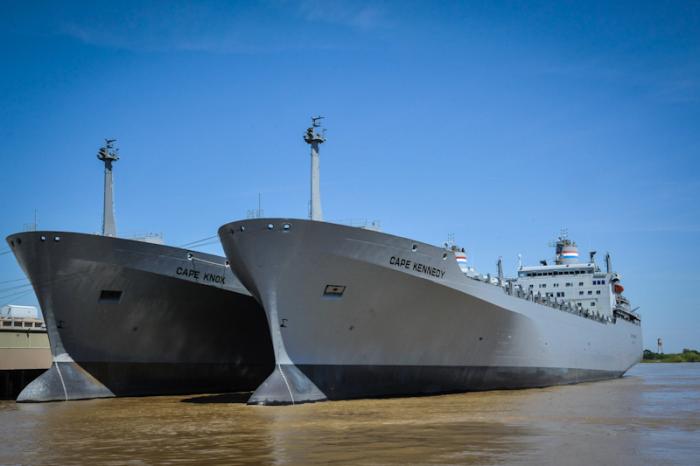
These two Cape K Class ships were laid down as commercial ro-ro cargo ships in the late 1970s and are now operated by the Military Sealift Command as part of the Ready Reserve Fleet. Both vessels are layberthed here in New Orleans in ROS-05 status, meaning they can be ready for service in 5 days or less once activated.
These ships are the following:
MV Cape Knox (T-AKR-5082)
www.marad.dot.gov/sh/ShipHistory/Detail/766
www.nvr.navy.mil/nvrships/details/AKR5082.htm
www.navsource.org/archives/09/54/545082.htm
MV Cape Kennedy (T-AKR-5083)
www.marad.dot.gov/sh/ShipHistory/Detail/764
www.nvr.navy.mil/nvrships/details/AKR5083.htm
www.navsource.org/archives/09/54/545083.htm
Nearby cities:
Coordinates: 29°57'28"N 90°1'58"W
- International Shipbreaking Limited 846 km
- ESCO Marine Inc. 847 km
- Lake Oroville Marina 3059 km
- Wreck of USS Independence (CVL-22) 3158 km
- Naval Submarine Base Bangor 3419 km
- Montague Harbour 3515 km
- SEAFAC Static Site surface barges 4341 km
- Battleship Row 6788 km
- Wreck of USS Nevada (BB-36) 6895 km
- Wreck of USS Belleau Wood (LHA-3) 6956 km
- Bywater 1.4 km
- Holy Cross 1.5 km
- St. Claude 1.9 km
- Lower Ninth Ward 2.2 km
- Arabi, Louisiana 3.4 km
- Algiers 4.1 km
- Industrial Canal (IHNC) 4.1 km
- Gentilly 6.1 km
- Bayou Bienvenue 10 km
- Central Wetlands 14 km