Lake Bakhtegan
Iran /
Fars /
Fasa /
World
/ Iran
/ Fars
/ Fasa
, 31 km from center (فسا)
lake, salt lake
Lake Bakhtegan, Lake Tashk and Kamjan marshes
Country/Territory
Iran, Islamic Republic of
Administrative region(s)
Fars
Central coordinates
53o 30' East 29o 40' North Map
Area
338000 ha
Altitude
1525 - 2597m
Criteria
A1, A4iii, B1i, B2
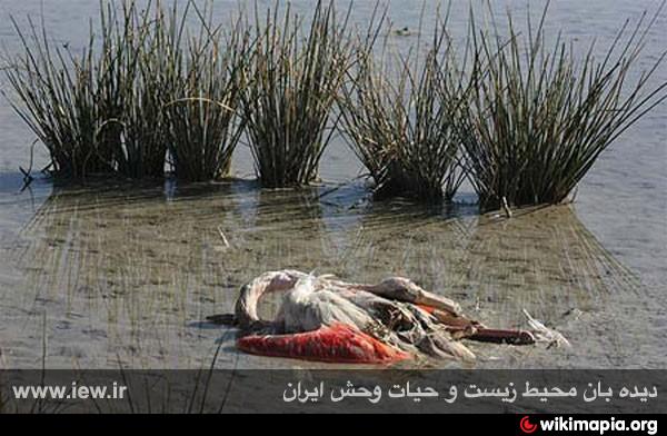
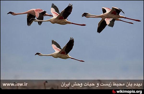
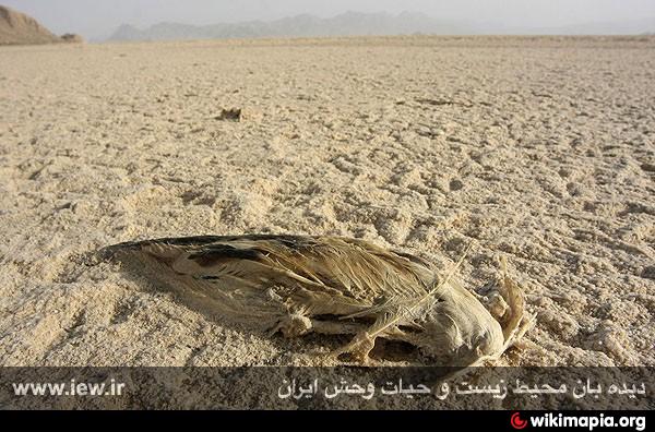
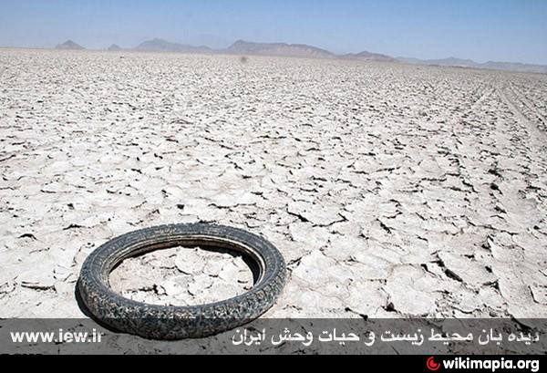
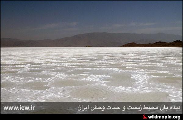
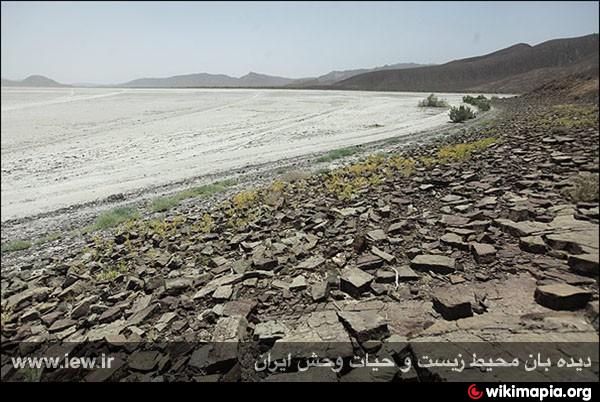
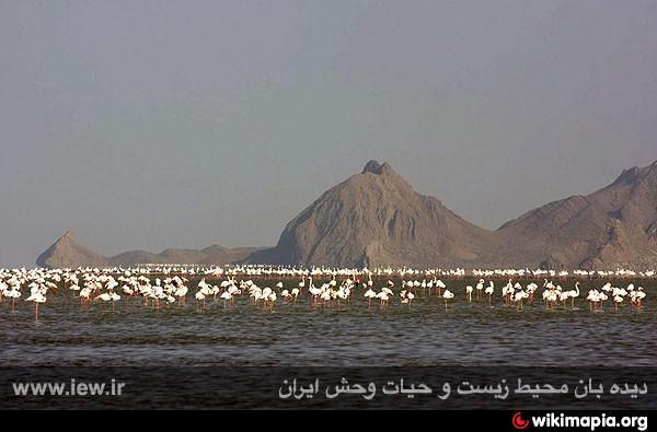
Site description The site lies in the eastern Zagros Mountains, 50-160 km east of Shiraz, and includes two very large salt-lakes, Tashk and Bakhtegan, in an internal drainage basin at 1,525 m, the intervening steppic plains and hills (to 2,597 m), and a large area of permanent freshwater marshes and seasonally flooded plains along the lower Kur river to the west (Kamjan Marshes). Lake Tashk is fed by overflow from the Kamjan Marshes at its west end and by a large permanent spring at Gumoon in the north-west. Lake Bakhtegan receives the bulk of its water from the main channel of the Kur which enters at the west. The two lakes are normally separated by narrow strips of land but may be joined during very wet winters to form a single expanse of water covering up to 136,500 ha. After several years of low rainfall, on the other hand, both lakes may dry out completely except in the vicinity of the main springs (e.g. Gumoon Spring at the north-west corner of Lake Tashk and Sahlabad Spring on the south shore of Lake Bakhtegan). Both lakes have an extraordinary range of salinities. In January 1992, the lakes were almost fully flooded, following several years of above-average rainfall. The lakes are oligotrophic and support a submerged vegetation of various algae, Chara, Ruppia and Althenia. Fringing vegetation consists of Tamarix, Suaeda, Cressa and Salicornia, and the area between the lakes comprises sparsely vegetated mountain ranges with some Pistacia woodland and steppic Artemisia plains.
Kamjan Marshes (29°40'N 53°05'E) formerly comprised c.10,000 ha of permanent and seasonal freshwater marshes, mainly reedbeds. Drainage of the wetland for rice farming began in 1967, and much has now been converted to agriculture. However, although the marshes have been extensively modified by the drainage canals, 5,250 ha of wetland remains, including expanses of wet mudflats, Phragmites and other emergent aquatic vegetation along canals, and large areas of rice fields. Furthermore, a large portion of the reclaimed land remains uncultivated because of a shortage of water for irrigation and because of the high salt content of the soils. Some irrigation canals are already silting up, and parts of the drained land are reverting to marsh. In addition, new marshes have developed at the mouths of the three main drainage canals where they enter the western ends of Lake Tashk and Lake Bakhtegan. The marshes are dominated by Carex, Phragmites, Chenopodiaceae and grasses. Livestock are grazed in the marshes and around the lake margins.
Source: www.birdlife.org
www.birdlife.org/datazone/sites/index.html?action=SitHT...
Country/Territory
Iran, Islamic Republic of
Administrative region(s)
Fars
Central coordinates
53o 30' East 29o 40' North Map
Area
338000 ha
Altitude
1525 - 2597m
Criteria
A1, A4iii, B1i, B2
Site description The site lies in the eastern Zagros Mountains, 50-160 km east of Shiraz, and includes two very large salt-lakes, Tashk and Bakhtegan, in an internal drainage basin at 1,525 m, the intervening steppic plains and hills (to 2,597 m), and a large area of permanent freshwater marshes and seasonally flooded plains along the lower Kur river to the west (Kamjan Marshes). Lake Tashk is fed by overflow from the Kamjan Marshes at its west end and by a large permanent spring at Gumoon in the north-west. Lake Bakhtegan receives the bulk of its water from the main channel of the Kur which enters at the west. The two lakes are normally separated by narrow strips of land but may be joined during very wet winters to form a single expanse of water covering up to 136,500 ha. After several years of low rainfall, on the other hand, both lakes may dry out completely except in the vicinity of the main springs (e.g. Gumoon Spring at the north-west corner of Lake Tashk and Sahlabad Spring on the south shore of Lake Bakhtegan). Both lakes have an extraordinary range of salinities. In January 1992, the lakes were almost fully flooded, following several years of above-average rainfall. The lakes are oligotrophic and support a submerged vegetation of various algae, Chara, Ruppia and Althenia. Fringing vegetation consists of Tamarix, Suaeda, Cressa and Salicornia, and the area between the lakes comprises sparsely vegetated mountain ranges with some Pistacia woodland and steppic Artemisia plains.
Kamjan Marshes (29°40'N 53°05'E) formerly comprised c.10,000 ha of permanent and seasonal freshwater marshes, mainly reedbeds. Drainage of the wetland for rice farming began in 1967, and much has now been converted to agriculture. However, although the marshes have been extensively modified by the drainage canals, 5,250 ha of wetland remains, including expanses of wet mudflats, Phragmites and other emergent aquatic vegetation along canals, and large areas of rice fields. Furthermore, a large portion of the reclaimed land remains uncultivated because of a shortage of water for irrigation and because of the high salt content of the soils. Some irrigation canals are already silting up, and parts of the drained land are reverting to marsh. In addition, new marshes have developed at the mouths of the three main drainage canals where they enter the western ends of Lake Tashk and Lake Bakhtegan. The marshes are dominated by Carex, Phragmites, Chenopodiaceae and grasses. Livestock are grazed in the marshes and around the lake margins.
Source: www.birdlife.org
www.birdlife.org/datazone/sites/index.html?action=SitHT...
Wikipedia article: http://en.wikipedia.org/wiki/Bakhtegan_Lake
Nearby cities:
Coordinates: 29°26'40"N 53°41'29"E
- Sirjan Salt Lake 149 km
- Aghda (Siah Kooh Kevir) playa 396 km
- Khour salt lake 548 km
- Osh Barmak Salt Lake 559 km
- Namak Lake 628 km
- Rud-e shurro River 645 km
- Bardaskan Playa 712 km
- Lake Urmia 1260 km
- The Great Rann of Kachchh (Kutch) 1610 km
- Pangong Lake 2389 km
- Bakhtegan Wildlife Refuge 11 km
- Bakhtegan National Park 15 km
- شهرک شهید باهنر 19 km
- Kharman Kuh 30 km
- Bakhtegan Wildlife Refuge 30 km
- Mian Jangal Fasa Protected Area 45 km