Lake Awassa
Ethiopia /
Southern /
Awassa /
World
/ Ethiopia
/ Southern
/ Awassa
World / Ethiopia / Southern Nations, Nationalities and Peoples / Sidama
lake
Add category


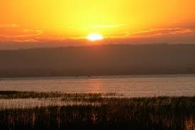


Lake Awassa, lying 268 km (167 miles) south of Addis Ababa, in the Main Ethiopian Rift (MER), surface elevation: 1,686 m (5,531 feet) above sea level, it is one of the extremely rare freshwater lakes with no visible outlet. The most persuasive explanation about the mysterious nature of the lake calls attention to the possible existence of underground water outflow for maintaining freshwater with low level of salinity.
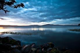
Tikur Wuha, the only perennial river feeding the lake drains the vast swamps of Wendo Genet area, which in itself drains the highlands on the east.
The surface area of the lake is about 95.84 km² (37 mi²), 16km (10miles) long, up to 8km (5 miles) wide, and it has estimated volume of 1.3 billion m³ (45.9 billion ft³). While the maximum depth of the lake is about 21.6 m (70.9 feet), its mean depth however is 10.7m (35 feet).
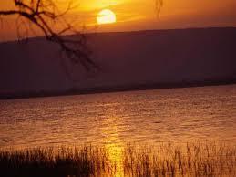
About half a dozen species of fish thrive in the lake, attracting various birds for feeding. Pelicans, storks, herons, hammerkops, sea eagles, kingfishers...etc. can be watched from the site of small scale fish market, on the shore at Amora Gedel. From large mammals, hippos are at home in the Lake, and can be viewed from small local boats that can be hired in the area.
Note: All measurements are based on satellite imagery and the combined tools of Google Earth and Wikimapia, except for depth and volume; and subject to change after satellite imagery updates
Tikur Wuha, the only perennial river feeding the lake drains the vast swamps of Wendo Genet area, which in itself drains the highlands on the east.
The surface area of the lake is about 95.84 km² (37 mi²), 16km (10miles) long, up to 8km (5 miles) wide, and it has estimated volume of 1.3 billion m³ (45.9 billion ft³). While the maximum depth of the lake is about 21.6 m (70.9 feet), its mean depth however is 10.7m (35 feet).
About half a dozen species of fish thrive in the lake, attracting various birds for feeding. Pelicans, storks, herons, hammerkops, sea eagles, kingfishers...etc. can be watched from the site of small scale fish market, on the shore at Amora Gedel. From large mammals, hippos are at home in the Lake, and can be viewed from small local boats that can be hired in the area.
Note: All measurements are based on satellite imagery and the combined tools of Google Earth and Wikimapia, except for depth and volume; and subject to change after satellite imagery updates
Wikipedia article: http://en.wikipedia.org/wiki/Lake_Awasa
Nearby cities:
Coordinates: 7°3'22"N 38°26'6"E
- Lake Shala 54 km
- Lake Abaya 105 km
- Lake Ziway 124 km
- Lake Chamo 162 km
- Chew Bahir 316 km
- Lake Fincha 321 km
- Lake Turkana 404 km
- Lake Abbe 590 km
- Grand Ethiopian Renaissance Reservoir 602 km
- Lake Bisina 783 km
- CPEL Awassa 5.4 km
- Wendo Genet Wetland 13 km
- Island In A Swamp 13 km
- Corbetti Volcano 16 km
- Wendo genet 19 km
- Senkelle Swayne's Hartebeest Sanctuary 20 km
- Bilate River field 37 km
- Abyata Shala National Park 55 km
- Tulu Fike (Mount Fike) 57 km
- Lencha Tiko 61 km
Comments