Qseyr el-Dibsi
Syria /
ar-Raqqah /
at-Tawrah /
World
/ Syria
/ ar-Raqqah
/ at-Tawrah
, 40 km from center (الثورة)
place with historical importance, archaeological site, ancient ruins
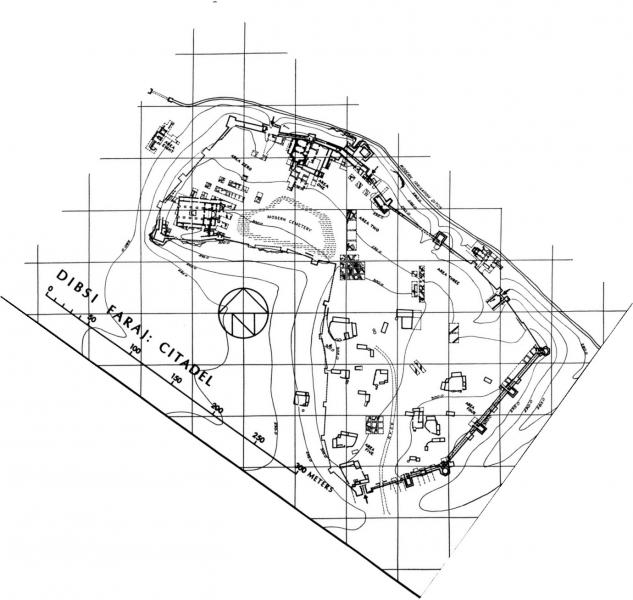
Also known as Dibsi Faraj, probably the site of ancient Roman Athis, Late Roman/Byzantine Neokaisareia, and Umayyad Qasrin. An alternative suggestion for identifying the site with Thapsacus (in part because of the seeming similarity of the two names' consonants) has not found acceptance. The site was located strategically close to the frontier with Persia and was substantially refortified in two stages, conventionally identified as Diocletianic and Justinianic, with walls, towers, and four gates. Most of the fortified citadel and all of the lower settlement are now submerged by the waters of Lake Assad, except for an area of higher ground (above 300 m) within the citadel, appearing as a small island. The site was investigated for five excavation seasons by archaeologists in 1972-1974, before it was submerged. While the visible part of the site features minor remains, the more impressive structures explored by archaeologists, including a church and basilica, are now underwater.
Wikipedia article: https://en.wikipedia.org/wiki/Dibsi_Faraj
Nearby cities:
Coordinates: 35°55'32"N 38°13'43"E
- Tell Meskene (Emar) 13 km
- Tell Munbâqa (Ekalte) 34 km
- Tell al-Sweyhat 39 km
- Ancient Sura 49 km
- Jebel Khalid 49 km
- Resafa 58 km
- Abassid Walls of Raqqa 71 km
- Thoul Nayel 79 km
- Khirbet al-Anbar (Bajadda) 102 km
- Medinet al-Far (Hisn Maslama) 105 km
- Abū Zurayjīyah 3.5 km
- Al Wāsiţah 7 km
- High Voltage Electricity Line 13 km
- Tabqa Dam Reservoir / Lake Assad 17 km
- Maskanah Subdistrict 18 km
- Maskaneh Plain 21 km
- Tabqa Civil Council (DFNS) 23 km
- Al-Mansurah Subdistrict (PCS) 49 km
- Al-Raqqah Governorate 62 km
- Euphrates Region (DFNS) 74 km