Zelyony Mys (Chersky)
Russia /
Saha /
Cherskiy /
Chersky
World
/ Russia
/ Saha
/ Cherskiy
, 11 km from center (Черский)
World / Russia / Chukot
seaport, quarter (urban subdivision)


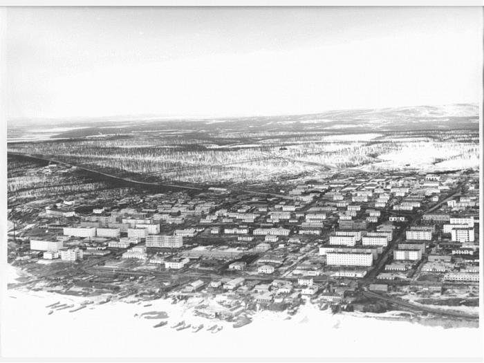
Zelyony Mys (Green Cape) - one of the largest ports of the Northern Way. The main base Anyuyskoy exploration expedition.
Geologists were going to settle in Western Chukotka seriously and permanently. Therefore, base Anyuyskoy future geological expedition, it was decided to place on the main traffic artery - Kolyma River.
By that time, in its lower reaches, there were several settlements of Yakutia: Medvezhka - on the shores of the Arctic Ocean, at the mouth of the homonymous river, Ambarchik - has long used a convenient place to approach ocean-going vessels, on the right bank of the Kolyma River - towns Mihalkino, Forest Region, Lower Cross, Lower Kolyma, Pyatistennoe (B. Anyue) ..
Choose at the village of Lower Cross, located at the mouth of river. Panteleihi. Under the existing river atlases, the depth of the Kolyma River in this location allows for mooring to the shore vessels «River - Sea»; terrace river. Panteleihi polar aviation, with the participation of the military departments of the country built the runway with all the necessary ground-based navigation to receive the type of aircraft IL-14, Li-2 water surface area of the river near the runway can receive the type of seaplanes «Catalina» and An - 2 on floats.
Yakut village of Lower Cross (later renamed the village. Cherskii) was located on a high rocky shore of woodlands: a group of houses chopped - poluzemlyanok; in the yard - a copybook fishing industry, and - cry, most of whom were trained in the service of sledding.
Place the construction of geological expedition chose to 3 km from the village, next to the cape, which was the name - Green. By the end of 1954, there has been a temporary mooring for boats and barges, construction began on the village: the office laid the expedition. Downhill to the river Kolyma area under the iron stores, began construction of «hotel» for coming. Group homes for permanent residents of the village placed above the slope, each in the two entrances to the general porches was fenced with low zaborchikom, for which the garden had been fitted with a seat for storage of river ice - a source of drinking water in winter, to summer porches were each barrel, which are regularly filled from the tank, it pulled on sleds tractor. Over time, were equipped mehtseh, Carpentry, dock for boats, garage for parking tractors. Here it was originally equipped and poluvrytaya in a stable ground for the Yakut horses, which were easier in-field geological survey and prospecting expedition parties. Stocky, unpretentious, they obtained a food everywhere, down to the local pomoek; winter accrete thick hair and hoofs of a dry grass from under the snow. Already in 1956, moved konbazu Village. Petushki - 20 km downstream river. Kolyma - they contain an abundance of grass allowed to voluntarily herd grazed all year round, summer horse deal for seasonal parties, for the winter distillate at konbazu.
First, the goods were imported to the warehouses Anyuyskoy expedition barge KIRPa (Kolyma - Indigirskogo river shipping) for r. Kolyma of Seymchana, Zyryanki. Over time, have been purchased several boats and barges - expedition proceeded to self. To do even attempt to deliver water to a large barge shipments on the river. Small Anuy to the village. Keperveem and the river. Omolon - to the village. Scherbakova.
The main transport unit based on a tractor convoy, on tractors transship cargo from barges to warehouses, in autumn 1954 tractor convoy paved his first zimnik Keperveem to the river, where the unfolded exploration-up the river Panteleihe through Povarnyu, the river. r.. Lyadinde, Uptinu, over the river. Pogynden - the river. Machvavaam.
In subsequent years zimnik to the Village. Bilibino was laid on the most optimal route, cleared and equipped for winter transport vehicles off-road.
Breaking bar (pebble shaft) at the mouth of river. Kolyma, Berths Cape Verde became moored ocean transport ships.
It was one thing, but very significant discomfort in the selection of the expedition; administrative territory belonged to the Yakut ASSR, pos. Lower Cross was the center of Lower Kolyma region of the republic. For the local leadership, the organization was a stranger, neighbor, any help we expect from them did not have to.
Since the beginning of the industrial development of open geologists gold placers p «Green Cape» chosen for its transshipment base Bilibino other companies - Mining and Concentration Combine, transporters, builders ... razrossya Village has acquired a modern type - multi-home storage area, office space filled the entire space Kolyma River in his cape, on its shore were built modern berths for mooring and unloading of ocean-going vessels, in a specially dug Zaton houses floating nuclear power plant «Northern Lights», which was electrically connected with Bilibino «atomkoy» and Pevekskoy CHP.
Village - Pyatikhatki Anyuyskoy expedition razrossya, modernize, was a «pocket» bilibintsev in Yakutia, the administrative village and community organizations were affiliated with Bilibino «masters» of communicating the good-neighborly basis. Now only preserved former house polusgnivshy «hotels» geologists on the river like the fiftieth year - youth and our expedition.
kpr.chukotka.ru / Public / Neznan / green.htm
Nearby cities:
Coordinates: 68°47'8"N 161°23'37"E
- Bay Ambarchik. «North Gate» DALSTROYA GULAG. 105 km
- Sea Port 364 km
- Nordvik 1803 km
- Cemetery 0.8 km
- Pushkina, 32 4.2 km
- ул. Маяковского д.15 4.6 km
- Chersky 4.7 km
- ул. Пушкина, 7 4.8 km
- Заброшенный жилой дом 4.8 km
- North-East Scientific Station FEB RAS 5.2 km
- Antonov An-26 5.2 km
- Fixed-wing cemetery 5.3 km
- Chersky Airport 5.3 km