Ukivok, King Island, Alaska
USA /
Alaska /
Wales /
World
/ USA
/ Alaska
/ Wales
unincorporated area / community, ghost town, historic ruins
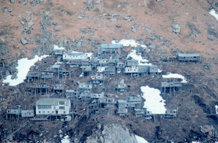
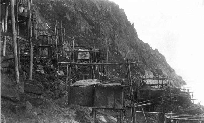
Former home of approximately 200 Inupiat who called themselves Ukivokmiut or Aseuluk. The Ukivokmiut had lived on the island for centuries, engaging in a subsistence hunting and fishing lifestyle. Due to a lack of flat ground on which to build homes, the people constructed their homes on stilts. Originally they built two types of home: summer homes were made from walrus-hide while winter homes had stone walls. These were later replaced with wooden buildings on stilts, the remains of which can be seen today.
In the 1950s, the Bureau of Indian Affairs claimed a boulder further up the cliff endangered the school and used it as a pretext to close the school and move all of the children to the mainland. Without the children to help gather winter food, the elders and adults had no choice but to move to the mainland. By 1970, the island was depopulated. Some Ukivokmiut continue to make trips to the island during the summer months to maintain the buildings and hunt walrus and seal.
The boulder that threatened the school still sits in the same spot to this day.
www.poa.usace.army.mil/Portals/34/docs/civilworks/BEA/K...
Wikipedia article: http://en.wikipedia.org/wiki/King_Island_(Alaska)
Nearby cities:
Coordinates: 64°57'42"N 168°4'14"W
- Fort Greely Garrison 1 1147 km
- United States Coast Guard Sitkinak LORAN A/C Station 1200 km
- Fort Brumback 1234 km
- Franklin, AK (Ghost Town) 1251 km
- Port of Chernofski Harbor 1286 km
- Korovinski, Alaska 1454 km
- Underground Fuel and Bomb Storage 1459 km
- Aircraft Pads 1460 km
- Sand Bay Naval Station (site) 1513 km
- Cape Yakak Aircraft Warning Station A-23 1571 km
- Port Clarence Bay 73 km
- Lopp Lagoon 86 km
- Grantley Harbor 94 km
- Bering Strait 111 km
- Imuruk Basin 114 km
- Ikpek Lagoon 115 km
- Shishmaref Inlet 169 km
- Golovnin Lagoon 236 km
- Imuruk Lake 238 km
- Imuruk Lake Volcano 238 km