Sherpur District
Bangladesh /
Sherpur /
World
/ Bangladesh
/ Sherpur
/ Sherpur
district, second-level administrative division, draw only border
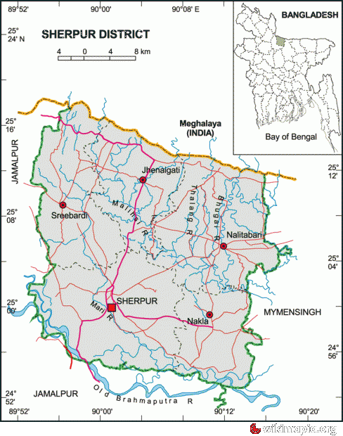

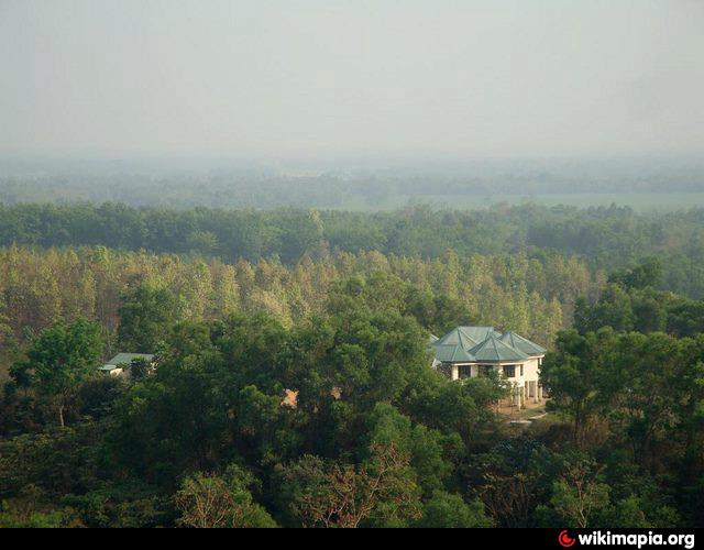
Sherpur District (dhaka division) with an area of 1363.76 sq km, is bounded by Garo hills of Meghalaya (India) on the north, mymensingh and jamalpur districts on the south, Mymensingh district on the east, Jamalpur district on the west. Annual average temperature maximum 33.3°C, minimum 12°C; annual rainfall 2174 mm; main rivers are Old Brahmaputra, Mrigi, Malijee, Bhogai, Chellashali and Maharashi. Shal, Segun and Gazari forests are notable.
Sherpur (Town) stands on the bank of the Mrigi. It was established in the seventeenth century. It consists of 9 wards and 56 mahallas. The area of the town is 23.39 sq km. The town has a population of 78749; male 52.22%, female 47.78%; density of population is 3367 per sq km. Literacy rate among the people is 38.6%. During the Mughal period Regional Administrative Centre was established in the town. Magistrate Court and Thana (Police Station) were established in the beginning of the nineteenth century. The Sherpur Municipality was established in 1869. The Telegraph Office and the Munsif Court were established in 1885 and 1887 respectively. Queen Victoria Memorial Academy was established in 1887 and Govinda Kumar Peace Memorial Institute was established in 1919.
Administration: Sherpur district was established in 1984; earlier it was a subdivision under the Mymensingh district. The district consists of one municipality, five upazilas, 51 union parishads, 2 municipalities, 18 wards, 73 mahallas, 458 mouzas and 699 villages. The upazilas are jhenaigati, nakla, nalitabari, sherpur sadar and sreebardi.
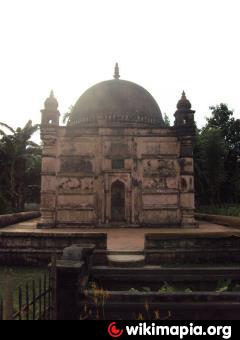
Archaeological heritage and relics: Garh Jaripar Fort (c 1486-91 AD), tomb of Darvish Jarip Shah, Baraduari Mosque, tomb of Hazrat Shah Kamal (1644 AD), tomb of Sher Ali Gazi, Mughal Mosque at Kasba, Ghagra Laskar Bari Mosque, Maisaheba Mosque, residences of Nay Ani, Arai Ani and Pouney Tin Ani Zamindars.
Historical events: Sherpur region was a part of the kingdom of the Kamrupa in the ancient time. During the reign of the Mughal Emperor Akbar this area was called "Dashkahania Baju". During the first part of the seventeenth century the Gazis of Bhawal occupied Dashkahania area from the descendants of Isa Khan. Doshkahania Pargana was named Sherpur after Sher Ali Gazi, the last jaghirdar of the Gazi dynasty. Fakir-Sannyasi Revolts were held against the East India Company and the local zamindars from the time of warren hastings to lord cornowalis; Tipu Shah, leader of the Fakir Movement, declared sovereignty in the area and established his capital at Gajripa. Peasant conferences were held in 1906, 1914 and 1917 at Kamarer Char of Sherpur under the leadership of Khos Muhammad Chowdhury. The communists revolted against the systems of Nankar, Tonk, Bhawali, Mahajani, Ijaradari during 1838-48 in Sherpur. In 1897 a devastating earth quack changed the course of the Brahmaputra towards the west and forced to merge it with the Jamuna; it also caused serious damages to many old buildings.
Population 1246511; male 50.87%, female 49.13%; Muslim 95%, Hindu 4%, Christian 0.5% and others 0.5%; ethnic nationals: Garo, Koch, Hajong, Banai and Rajbanshi. These ethnic nationals have their own languages.
Religious institutions: Mosque 1403, temple 79, church 15, tomb 15, sacred place 1.
Literacy and educational institutions: Average literacy 32.4%; male 38.6% and female 26.2%. Educational institutions: government college 3, non-government college 11, government high school 3, non-government high school 92, junior high school 27, government primary school 358, non-government primary school 275, madrasa 194, agricultural training institute 1, nursing training institute 1, vocational training institute 1. Noted educational institutions are Sherpur Victoria Memorial Academy (1887), Govinda Kumar Peace Memorial Institute (1919), Chandrakanta Government Primary School (1944), Sherpur Government Girl's High School (1952), Sherpur Government College (1964).
Cultural organisations: Club 93, public library 4, drama stage 3, theatre group 15, literary society 5, women's organisation 30, cinema hall 13, Shilpakala Academy 1, Shishu Academy 1.
Main occupations: Agriculture 46.51%, fishing 1.45%, agricultural labourer 23.61%, wage labourer 3.01%, commerce 9.5%, service 3.14%, transport 1.32% and others 11.46%.
Land use: Total cultivable land 106544 hectares; fallow land 716 hectares; single crop 19%, double crop 68.6% and treble crop 12.4%; land under irrigation 65%.
Land control: Among the peasants, 21% are landless, 40% small, 35% intermediate and 4% rich; cultivable land per head 0.07 hectare.
Fisheries, dairies, poultries Dairy 63, poultry 102, fishery 131, hatchery 12.
Communication facilities Roads: pucca 492.32 km, semi pucca 154.42 km and mud road 1889.23 km.
Manufactories:Ice factory 23, sawmill 47, wheat mill 27, flower mill 11, oil mill 28, rice mill 332, bidi factory 2
Main exports Paddy, jute, vegetables, rubber, stone, sand, bamboo.
NGO activities: Operationally important NGOs are CARE, brac, proshika, asa, Gonoshahajjo Sangstha, caritas, World Vision, SPS and SDS.
Health centres: Zila sadar hospital 1, upazila health complex 5, health and family planning centre 52, diabetic centre 1, maternity and child welfare centre 1, tuberculosis satellite centre 1, leprosy satellite centre 1, mission hospital 1, Gana Sastha centre 2, safe community programme 1, satellite clinic 17, TB clinic 1, non-government clinic 2.
Sherpur (Town) stands on the bank of the Mrigi. It was established in the seventeenth century. It consists of 9 wards and 56 mahallas. The area of the town is 23.39 sq km. The town has a population of 78749; male 52.22%, female 47.78%; density of population is 3367 per sq km. Literacy rate among the people is 38.6%. During the Mughal period Regional Administrative Centre was established in the town. Magistrate Court and Thana (Police Station) were established in the beginning of the nineteenth century. The Sherpur Municipality was established in 1869. The Telegraph Office and the Munsif Court were established in 1885 and 1887 respectively. Queen Victoria Memorial Academy was established in 1887 and Govinda Kumar Peace Memorial Institute was established in 1919.
Administration: Sherpur district was established in 1984; earlier it was a subdivision under the Mymensingh district. The district consists of one municipality, five upazilas, 51 union parishads, 2 municipalities, 18 wards, 73 mahallas, 458 mouzas and 699 villages. The upazilas are jhenaigati, nakla, nalitabari, sherpur sadar and sreebardi.
Archaeological heritage and relics: Garh Jaripar Fort (c 1486-91 AD), tomb of Darvish Jarip Shah, Baraduari Mosque, tomb of Hazrat Shah Kamal (1644 AD), tomb of Sher Ali Gazi, Mughal Mosque at Kasba, Ghagra Laskar Bari Mosque, Maisaheba Mosque, residences of Nay Ani, Arai Ani and Pouney Tin Ani Zamindars.
Historical events: Sherpur region was a part of the kingdom of the Kamrupa in the ancient time. During the reign of the Mughal Emperor Akbar this area was called "Dashkahania Baju". During the first part of the seventeenth century the Gazis of Bhawal occupied Dashkahania area from the descendants of Isa Khan. Doshkahania Pargana was named Sherpur after Sher Ali Gazi, the last jaghirdar of the Gazi dynasty. Fakir-Sannyasi Revolts were held against the East India Company and the local zamindars from the time of warren hastings to lord cornowalis; Tipu Shah, leader of the Fakir Movement, declared sovereignty in the area and established his capital at Gajripa. Peasant conferences were held in 1906, 1914 and 1917 at Kamarer Char of Sherpur under the leadership of Khos Muhammad Chowdhury. The communists revolted against the systems of Nankar, Tonk, Bhawali, Mahajani, Ijaradari during 1838-48 in Sherpur. In 1897 a devastating earth quack changed the course of the Brahmaputra towards the west and forced to merge it with the Jamuna; it also caused serious damages to many old buildings.
Population 1246511; male 50.87%, female 49.13%; Muslim 95%, Hindu 4%, Christian 0.5% and others 0.5%; ethnic nationals: Garo, Koch, Hajong, Banai and Rajbanshi. These ethnic nationals have their own languages.
Religious institutions: Mosque 1403, temple 79, church 15, tomb 15, sacred place 1.
Literacy and educational institutions: Average literacy 32.4%; male 38.6% and female 26.2%. Educational institutions: government college 3, non-government college 11, government high school 3, non-government high school 92, junior high school 27, government primary school 358, non-government primary school 275, madrasa 194, agricultural training institute 1, nursing training institute 1, vocational training institute 1. Noted educational institutions are Sherpur Victoria Memorial Academy (1887), Govinda Kumar Peace Memorial Institute (1919), Chandrakanta Government Primary School (1944), Sherpur Government Girl's High School (1952), Sherpur Government College (1964).
Cultural organisations: Club 93, public library 4, drama stage 3, theatre group 15, literary society 5, women's organisation 30, cinema hall 13, Shilpakala Academy 1, Shishu Academy 1.
Main occupations: Agriculture 46.51%, fishing 1.45%, agricultural labourer 23.61%, wage labourer 3.01%, commerce 9.5%, service 3.14%, transport 1.32% and others 11.46%.
Land use: Total cultivable land 106544 hectares; fallow land 716 hectares; single crop 19%, double crop 68.6% and treble crop 12.4%; land under irrigation 65%.
Land control: Among the peasants, 21% are landless, 40% small, 35% intermediate and 4% rich; cultivable land per head 0.07 hectare.
Fisheries, dairies, poultries Dairy 63, poultry 102, fishery 131, hatchery 12.
Communication facilities Roads: pucca 492.32 km, semi pucca 154.42 km and mud road 1889.23 km.
Manufactories:Ice factory 23, sawmill 47, wheat mill 27, flower mill 11, oil mill 28, rice mill 332, bidi factory 2
Main exports Paddy, jute, vegetables, rubber, stone, sand, bamboo.
NGO activities: Operationally important NGOs are CARE, brac, proshika, asa, Gonoshahajjo Sangstha, caritas, World Vision, SPS and SDS.
Health centres: Zila sadar hospital 1, upazila health complex 5, health and family planning centre 52, diabetic centre 1, maternity and child welfare centre 1, tuberculosis satellite centre 1, leprosy satellite centre 1, mission hospital 1, Gana Sastha centre 2, safe community programme 1, satellite clinic 17, TB clinic 1, non-government clinic 2.
Wikipedia article: http://en.wikipedia.org/wiki/Sherpur_District
Nearby cities:
Coordinates: 25°5'45"N 90°5'21"E
- Habigonj District 113 km
- Sylhet District 154 km
- Maulvibazar District 158 km
- Khagrachari District 224 km
- Noakhali District 240 km
- Rangamati District 247 km
- Bhola District 257 km
- Chattogram District Area 271 km
- Lhuentse Dzongkhag 338 km
- District Upper Siang (AP) 626 km
- Aura Baura Beel 8.5 km
- Nalitabari Upazila HQ 10 km
- Mausi Beel 11 km
- Nakla Upazila HQ 17 km
- Haluaghat Upazila HQ 26 km
- Gurakandha 27 km
- Phulpur Upazila HQ 32 km
- Dhobaura Upazila 39 km
- Dhaka Division 109 km
- Meghalaya 134 km