Rangamati District
Bangladesh /
Khagrachhari /
Khagrachari /
Rangamati
World
/ Bangladesh
/ Khagrachhari
/ Khagrachari
World / Bangladesh / Chittagong / Rangamati / Parbattya Chattagram
hills, district, draw only border, third-level administrative division, tourist attraction
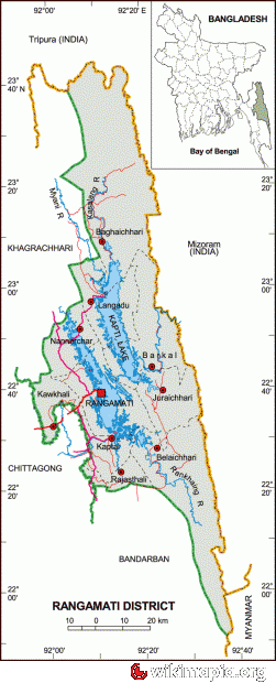
Rangamati(Bengali:রাঙ্গামাটি পার্বত্য জেলা) is a district in South-eastern Bangladesh. It is a part of the Chittagong Hill Tracts and the town of Rangamati serves as the headquarters of the district. Area-wise, Rangamati is the largest district of the country.
Rangamati is located in the Chittagong Division. The total area of the district is 6116.13 sq km. It is bordered by the Tripura state of India to the north, Bandarban District to the south, Mizoram State of India and Chin State of Myanmar to the east, and Khagrachari and Chittagong Districts to the west.
It’s a combination of Hill- Lake-Plain land The area of the district is 6116.13 km2 of which 1291.5 km2 is riverine and 4824.63 km2.is under forest vegetation and the lake area is about 650 km2.
The total population is 5,08,182 according to 2005 census of which tribal 52% and non-tribal 48%. The number of males is 2,87,060 and the females are 2,38,043 (Census 2001). The density of population is 83 per square kilometer (Census 2001). The number of household is 1,03,974 having the household size 4.8 (Census 2001). The total population is divided into Bangalees and eleven tribes (ethnic minorities): Chakma, Marma, Tanchangya, Tripura, Pankua, Lushi, Khiang, Murang, Rakhain, Chak, Bowm,Khumi.
Tribal population : (as per census of 2005 ):
Chakma-1,86,395, Marma-44,727, Tanchanga-18,607, Tripura-6,697, Pankho- 2,118, Bowm-1,053, khyang- 791, Lusai- 217, Chak- 177, Rakhain-70, Khumi-50,Gurkha-03,Etc.
As per 1991 census, the religious break up of the population of the district were: Buddhist 53.83%,Muslim 39.28%, Hindu 5.62% and Christian 1.12%. Religious institutions Pagoda 1230, Mosque 1059, Temple 65, Church 16. Genderwise, male constituted 53.59% and female constituted 46.41% of the population.
Rangamati was a contesting ground for the kings of Tripura and Arakan. This region came under the Mughal Empire after the Muslim invasion in 1566.
In 1737 Sher Mosta Khan,a tribal leader,took refuge with the Mughals. After this the Chakma settlement began along with various other settlements of varying ethnicity.
From 1760 to 1761,this land was leased to the East India Company.
Rangamati(Bengali: রাঙ্গামাটি) is the Administrative Headquarter of Rangamati Hill District in the Chittagong Hill Tracts of Bangladesh. The town is located at 22°37'60N 92°12'0E and has an altitude of 14 metres (49 feet).
It's a travel destination of Bangladesh which is known as "Lake City".
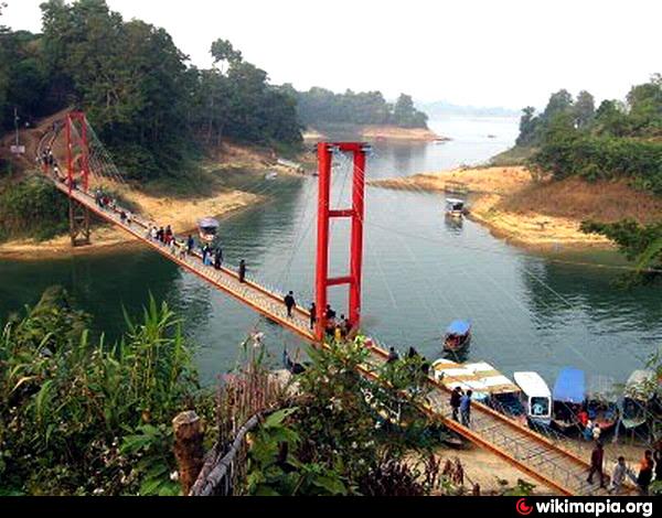
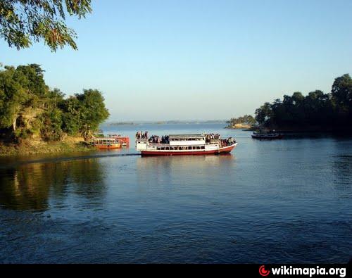
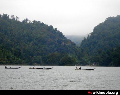
From Chittagong a 77 km road amidst green fields and winding hills leads to Rangamati; which is a wonderful repository of scenic splendours with flora and fauna of varied descriptions. The township is located on the western bank of the Kaptai lake. Rangamati is a favourite holiday destination because of its beautiful landscape, scenic beauty, lake, colourful indigenus groups (Chakma, Marma etc.), its flora and fauna, indigenous museum, hanging bridge, homespun textile products, ivory jewellery and the indigenous men and women who fashion them. For tourists, the attractions of Rangamati are numerous. Indigenous life, fishing, speed boat cruising, hiking, bathing or merely enjoying nature as it is.
Rangamati Town is mainly divided into 13 areas. Namely Vedvedi, Collegegate, Rajbari, Newmarket, Banarupa, Kathaltoli, Fishery Ghath, Reserve Bazar, Launch Ghath, Pathor Ghata, Tabalchori, Mazher Basti, Asam Basti.
Places of interest:
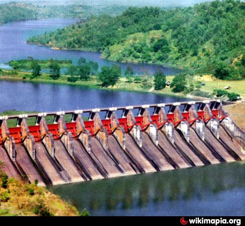
Kaptai has Bangladesh's only hydro-electric project. The Kaptai Dam on the Karnaphuli River created for this purpose resulted in the Kaptai Lake.
Tourist spots include the Hanging Bridge over the Kaptai Lake,the remnants of the residence of Raja Harish Chandra Roy,archeological relics and heritage such as the Palace,Mosque and Dighi of Raja Jan Bashk Khan.
Cruising on the Kaptai Lake is an enjoyable way of observing the landscape as many great picnic spots, natural landmarks and historic monuments are accessible only by motorboats.The Rangamati Parjatan offers such tours to the tourists, taking them to great sights, locations of cultural and historical significance while explaining the diversity that exists in this district.
There are several waterfalls in the hill tracts adjoining the lake,more prominent during the monsoon because of the increased water levels due to rainfall.
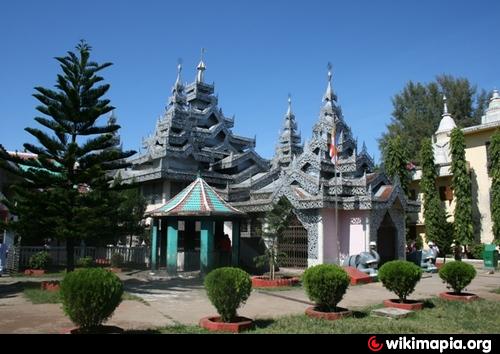
Scattered throughout the district,are beautiful Buddhist temples and ancient relics of civilizations,all accessible by motor vehicles.
A stretch of road connects the tourist spots of Rangamati and Kaptai. The road goes deep into the hill tracts and displays the natural beauty and wildlife of the district.
Rangamati is located in the Chittagong Division. The total area of the district is 6116.13 sq km. It is bordered by the Tripura state of India to the north, Bandarban District to the south, Mizoram State of India and Chin State of Myanmar to the east, and Khagrachari and Chittagong Districts to the west.
It’s a combination of Hill- Lake-Plain land The area of the district is 6116.13 km2 of which 1291.5 km2 is riverine and 4824.63 km2.is under forest vegetation and the lake area is about 650 km2.
The total population is 5,08,182 according to 2005 census of which tribal 52% and non-tribal 48%. The number of males is 2,87,060 and the females are 2,38,043 (Census 2001). The density of population is 83 per square kilometer (Census 2001). The number of household is 1,03,974 having the household size 4.8 (Census 2001). The total population is divided into Bangalees and eleven tribes (ethnic minorities): Chakma, Marma, Tanchangya, Tripura, Pankua, Lushi, Khiang, Murang, Rakhain, Chak, Bowm,Khumi.
Tribal population : (as per census of 2005 ):
Chakma-1,86,395, Marma-44,727, Tanchanga-18,607, Tripura-6,697, Pankho- 2,118, Bowm-1,053, khyang- 791, Lusai- 217, Chak- 177, Rakhain-70, Khumi-50,Gurkha-03,Etc.
As per 1991 census, the religious break up of the population of the district were: Buddhist 53.83%,Muslim 39.28%, Hindu 5.62% and Christian 1.12%. Religious institutions Pagoda 1230, Mosque 1059, Temple 65, Church 16. Genderwise, male constituted 53.59% and female constituted 46.41% of the population.
Rangamati was a contesting ground for the kings of Tripura and Arakan. This region came under the Mughal Empire after the Muslim invasion in 1566.
In 1737 Sher Mosta Khan,a tribal leader,took refuge with the Mughals. After this the Chakma settlement began along with various other settlements of varying ethnicity.
From 1760 to 1761,this land was leased to the East India Company.
Rangamati(Bengali: রাঙ্গামাটি) is the Administrative Headquarter of Rangamati Hill District in the Chittagong Hill Tracts of Bangladesh. The town is located at 22°37'60N 92°12'0E and has an altitude of 14 metres (49 feet).
It's a travel destination of Bangladesh which is known as "Lake City".
From Chittagong a 77 km road amidst green fields and winding hills leads to Rangamati; which is a wonderful repository of scenic splendours with flora and fauna of varied descriptions. The township is located on the western bank of the Kaptai lake. Rangamati is a favourite holiday destination because of its beautiful landscape, scenic beauty, lake, colourful indigenus groups (Chakma, Marma etc.), its flora and fauna, indigenous museum, hanging bridge, homespun textile products, ivory jewellery and the indigenous men and women who fashion them. For tourists, the attractions of Rangamati are numerous. Indigenous life, fishing, speed boat cruising, hiking, bathing or merely enjoying nature as it is.
Rangamati Town is mainly divided into 13 areas. Namely Vedvedi, Collegegate, Rajbari, Newmarket, Banarupa, Kathaltoli, Fishery Ghath, Reserve Bazar, Launch Ghath, Pathor Ghata, Tabalchori, Mazher Basti, Asam Basti.
Places of interest:
Kaptai has Bangladesh's only hydro-electric project. The Kaptai Dam on the Karnaphuli River created for this purpose resulted in the Kaptai Lake.
Tourist spots include the Hanging Bridge over the Kaptai Lake,the remnants of the residence of Raja Harish Chandra Roy,archeological relics and heritage such as the Palace,Mosque and Dighi of Raja Jan Bashk Khan.
Cruising on the Kaptai Lake is an enjoyable way of observing the landscape as many great picnic spots, natural landmarks and historic monuments are accessible only by motorboats.The Rangamati Parjatan offers such tours to the tourists, taking them to great sights, locations of cultural and historical significance while explaining the diversity that exists in this district.
There are several waterfalls in the hill tracts adjoining the lake,more prominent during the monsoon because of the increased water levels due to rainfall.
Scattered throughout the district,are beautiful Buddhist temples and ancient relics of civilizations,all accessible by motor vehicles.
A stretch of road connects the tourist spots of Rangamati and Kaptai. The road goes deep into the hill tracts and displays the natural beauty and wildlife of the district.
Wikipedia article: http://en.wikipedia.org/wiki/Rangamati
Nearby cities:
Coordinates: 22°47'12"N 92°19'12"E
- Chattogram District Area 95 km
- Khagrachari District 122 km
- Noakhali District 155 km
- Bhola District 207 km
- Maulvibazar District 234 km
- Habigonj District 253 km
- Sylhet District 277 km
- Zhemgang Dzongkhag 543 km
- Lhuentse Dzongkhag 608 km
- District Upper Siang (AP) 753 km
- Barkal Upazila HQ 8.3 km
- Kaptai Lake 12 km
- Kaptai Lake (কাপ্তাই লেক) 17 km
- Juraichari Upazila HQ 17 km
- Nunsuri II 18 km
- Lamthai III 19 km
- Rangamati Dist Town 22 km
- District Head Quarter of Border Guard Bangladesh 23 km
- Nannerchar Upazila HQ 23 km
- Mizoram 74 km