Juraichari Upazila HQ
Bangladesh /
Rangamati /
Kaptai /
World
/ Bangladesh
/ Rangamati
/ Kaptai
World / Bangladesh / Chittagong / Rangamati / Parbattya Chattagram
township, subdistrict, fourth-level administrative division, local government
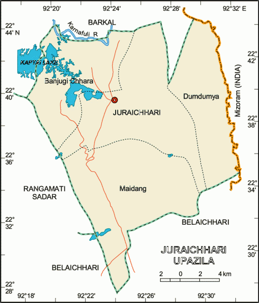
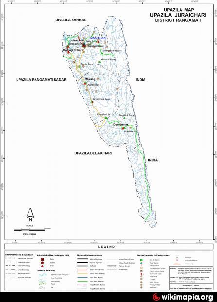
Juraichhari Upazila (Rangamati district) with an area of 606.05 sq km, is bounded by Barkal upazila on the north, Belaichhari upazila on the south, Mizoram (India) on the east and Rangamati sadar and Barkal upazilas on the west. Main river is The Karnafuli. Part of Kaptai lake on the north-western corner of the upazila.
The location of the Juraichari town is 22.6667°N 92.3833°E. Juraichhari (Town) consists of one mouza. The area of the town is 69.93 sq. km. The town has a population of 2438; male 54.42%, female 45.58%. Density of population is 35 per sq km. Literacy rate among the town people is 37.9%. The town has one dakbungalow.
Juraichhari thana was established in 1976 and was turned into an upazila in 1983. It consists of 4 union parishads, 9 mouzas and 108 villages.
As of the 1991 Bangladesh census: Population 11621; male 52.16%, female 47.84%; Muslim 3.70%, Hindu 0.95%, Buddhist 92.27% and Christian 3.08%.
Religious institutions: Mosque 5, temple 1, church 1, pagoda 15.
Literacy and educational institutions: Average literacy 23.4%; male 31.5% and female 14.4%. Educational institutions: college 1, high school 7, junior school 2, community school 3, government primary school 25, non-government primary school 4.
Cultural organisation: Club 12, women's organisation 4.
Main occupations: Agriculture 79.83%, agricultural labourer 7.43%, wage labourer 1.44%, commerce 3.23%, service 4.93%, and others 3.14%.
Land use: Cultivable land 1660 hectares, fallow land 2964 hectares; single crop 74.4%, double crop 20.24% and treble crop land 5.36%; land under irrigation 417 hectares.
Land control: Among the peasants 20% are landless, 36% small, 24% intermediate and 20% rich.
Main crops Paddy, corn, potato, sweet potato, cotton, tobacco, pulse.
Communication facilities- Roads: semi pucca 5.24 km, mud road 147.4 km.
Cottage industries: Goldsmith 5, blacksmith 3, wood work 4.
Health centres: Upazila health complex 1, family planning centre 1.
Nearby cities:
Coordinates: 22°39'9"N 92°23'41"E
- Chandanaish Upazila 62 km
- Patiya Upazila (পটিয়া) 70 km
- Banshkhali Upazila (বাঁশখালী উপজেলা) 77 km
- Matlab Upazila (North) Area 210 km
- Rupganj Upazila 238 km
- Lohajang Upazila 243 km
- Keraniganj Upazila 251 km
- Kapashia Upazila 265 km
- Gafargaon Upazila 289 km
- Dhobaura Upazila 352 km
- Rangamati District 17 km
- Kaptai Lake (কাপ্তাই লেক) 20 km
- District Head Quarter of Border Guard Bangladesh 22 km
- Rangamati Dist Town 24 km
- Nunsuri II 26 km
- Kaptai Lake 29 km
- Lamthai III 30 km
- Chattogram District Area 66 km
- Khagrachari District 75 km
- Mizoram 80 km