Chandanaish Upazila
| subdistrict, fourth-level administrative division, local government
Bangladesh /
Chattagam /
Satkaniya /
World
/ Bangladesh
/ Chattagam
/ Satkaniya
World / Bangladesh / Chittagong / Chittagong / Chittagong
subdistrict, fourth-level administrative division, local government
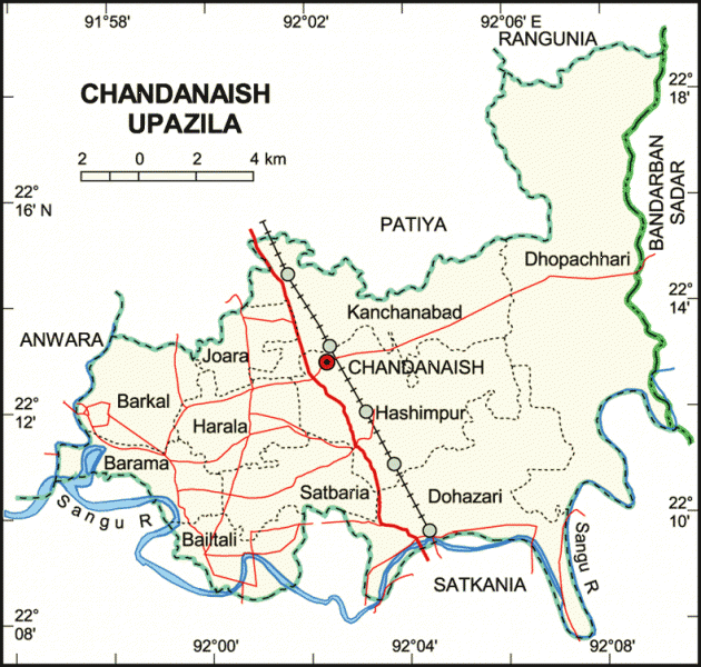
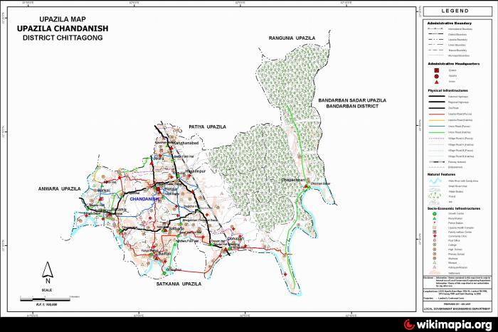
Chandanaish Upazila (Chittagong district) with an area of 201.99 sq km, is bounded by Patiya and Rangunia upazilas on the north, Satkania upazila on the south, Bandarban sadar and Satkania upazilas on the east, Anwara upazila on the west. Main rivers are Sangu and Chankhali.
Chandanaish is located at 22.2111°N 92.0417°E. Chandanaish (Town) consists of two mouzas. It has an area of 3.88 sq km. The town has a population of 9678; male 51.69%, female 48.31%; population density per sq km 2494. Literacy rate among the town people is 39.2%. The town has one dakbungalow.
Chandanaish thana, now an upazila, was established in 1976. The upazila consists of 10 union parishads, 43 mouzas and 56 villages.
Archaeological heritage and relics: Three domed Khan Mosque (Dohazari and Baghica Hat); Chendi Muni Fora Buddha Statue (Satbaria).
Historical events The Mughal army captured northern chittagong in 1666; later, the Mughal army crossed the karnafuli river and established their position at the northern bank of the Sangu River under Murtoza Kha. Adhu Khan and Lakshman Singh, two hazari mansabdars were deputed to defend the border of that area. Dohazari was named after the mansabdars. Later on, two forts were built there. The British built an air base at Dohazari.
Religious institutions: Mosque 275, tomb 20, temple 70, Kiyang 11 and sacred place 1, most noted of which are three domed Khan Mosque, Satbaria Shanti Bihar (monastery), Gachbaria Sarbojanin Hari Mandir and Baruni Snan at Barumati Canal.
As of the 1991 Bangladesh census: Population 172843; male 51.27%, female 48.73%; Muslim 80.52%, Hindu 14.63%, Buddhist 3.23% and Tribal people 1.62%.
Literacy and educational institutions: Average literacy 33.9%; male 40.1%, female 27.4%. Educational institutions: college 5, high school 23, government primary school 64, non-government primary school 19, vocational training centre 1, madrasa 279.
Cultural organisations: Rural club 20, press club 2, cinema hall 2, women's organisation 1, stadium 1.
Main occupations: Agriculture 28.10%, forestry 3.82%, agricultural labourer 15.65%, wage labourer 3.7%, industry 1.89%, commerce 16.97%, transport 3.02%, construction 1.11%, service 13.21% and others 12.53%.
Land use: Total cultivable land 9745.04 hectares; fallow land 91.87 hectares; plain land 50%; hilly land 30% marginal land 20%; single crop 40%, double crop 43% and treble crop land 17%. Cultivable land under irrigation 53%.
Land control: Among the peasants 54% are landless, 20% marginal, 14% small, 10% intermediate and 2% rich; cultivable land per head 0.09 hectare.
Main crops: Paddy, potato, chilli, mustard seed, various kitchen vegetables.
Fisheries, dairies, poultries Fishery 240, hatchery 3 and dairy 1.
Communication facilities- Roads: pucca 30 km, semi pucca 50 km and mud road 150 km; waterways 19 nautical mile; railways 12 km.
Manufactories: Garment industry 2, cold storage 2, ice factory 3, printing press 2, saw mill 35, welding 10, rice and flour mill 133.
Cottage industries: Weaving 30, goldsmith 20, blacksmith 30, potteries 40, wood work 60, bamboo work 150, bakery 30 and sewing 168.
Main exports: Railway slipper, wooden furniture, wood, milk, chicken, guava, lemon, pineapple, various kitchen vegetables.
NGO activities: Operationally important NGOs are brac, asa, grameen bank, Uddipan, caritas and Rural Advancement Authority.
Health centres: Government hospital 2 and health & family planning centre 7.
Nearby cities:
Coordinates: 22°12'19"N 92°2'54"E
- Banshkhali Upazila (বাঁশখালী উপজেলা) 21 km
- Anwara Upazila (আনোয়ারা) 25 km
- Patiya Upazila (পটিয়া) 31 km
- Sandwip 79 km
- Fatikchhari Upazila (ফটিকছড়ি উপজেলা) 98 km
- Ramgati Upazila HQ 130 km
- Kamalnagar Upazila HQ 140 km
- Meghna Upazila 219 km
- Rupganj Upazila 248 km
- Dhobaura Upazila 376 km
- Bodurpara Area 3.8 km
- Shadbaia Para Chandanish, Chittagong, 4.1 km
- Shadbaria 4.1 km
- Kanchanabad Chandanish 4.2 km
- dokin Harala Chandanish, chittagong 5.3 km
- borkol molobi bazzar aria 8.8 km
- Bangladesh Rifles Training Centre 11 km
- আশিয়া ইউনিয়ন 13 km
- Chattogram District Area 38 km
- Bandarban District 58 km
Comments