Meghna Upazila
Bangladesh /
Gazipur /
World
/ Bangladesh
/ Gazipur
/ Gazipur
draw only border, subdistrict, fourth-level administrative division, tourist attraction
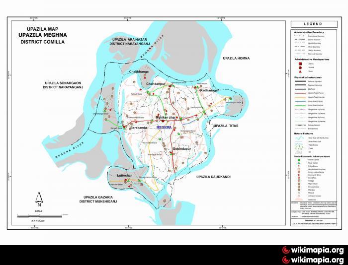
Meghna is a newer Upzila of Bangladesh of Comilla District in the Chittagong Division, Bangladesh. It is bounded by Araihazar upazila on the north, Gojaria and Daudkandi on the south, Homna and Titas on the east, and Sonargaon on the west. Previously, it was part of Daukandi and Homna. Country’s largest river Meghna is situated here and hence Bangladesh Government named Meghna Upazila after it.
The location of the Meghna town is 23.6285872N 90.6944507E.
Area: 98.47 sq. km
Population (around): 100,000
Population Density: 985 per sq. km
Total Unions: 7
Total Mouzas: 41
Government Hospital: 1
Upazila Clinics: 4
Hat Bazaar: 17
Major occupation: Fishing and agriculture
Post Offices: 6
Post Code: 3516.
Nearby cities:
Coordinates: 23°36'57"N 90°42'2"E
- Chittagong Division 60 km
- Gazipur District 94 km
- Chittagong District Area 102 km
- Rangamati District 135 km
- Habigonj District 138 km
- Sylhet Division 178 km
- Pemagatshel Dzongkhag 398 km
- Sarpang Dzongkhag 407 km
- Samdrup Jonkhar Dzongkhag 411 km
- Nagaland 475 km
- Meghna Upazila HQ 1.6 km
- Meghna Ghat (west) 10 km
- Meghna Ghat (east) 10 km
- Sonargaon Upazila HQ 10 km
- Merging of Dhaleshwari with Meghna 15 km
- Bandar Upazila HQ 18 km
- adamjee 19 km
- paragon city development-rupgonj 19 km
- Munshiganj Dist Town 20 km
- Dhaka Division 69 km