Sonargaon Upazila HQ
Bangladesh /
Narayanganj /
World
/ Bangladesh
/ Narayanganj
/ Narayanganj
World / Bangladesh / Dhaka / Dhaka / Naray Angonj
township, fourth-level administrative division, historic site, historic ruins


Sonargaon Upazila (Narayanganj district) with an area of 171.66 sq km, is bounded by Araihazar and Rupganj upazilas on the north, Munshiganj sadar and Gazaria upazilas on the south, Homna and Gazaria upazilas on the east, Bandar (Narayanganj), Narayanganj sadar, Rupganj upazilas and Demra thana on the west. The upazila is washed by the Meghna and Shitalakshya. The original Brahmaputra river which once flew through the upazila is now moribund.
The location of Sonargaon town is 23.6413533N 90.6036073E. Sonargaon (Town) consists of 6 mouzas. The area of the town is 0.73 sq km. It has a population of 4039; male 53.31%, female 46.69%. The literacy rate among the town people is 51%. The town has one dakbungalow.
Sonargaon thana was turned into a upazila in 1983. It consists 11 union parishads, 466 villages and 352 mouzas.
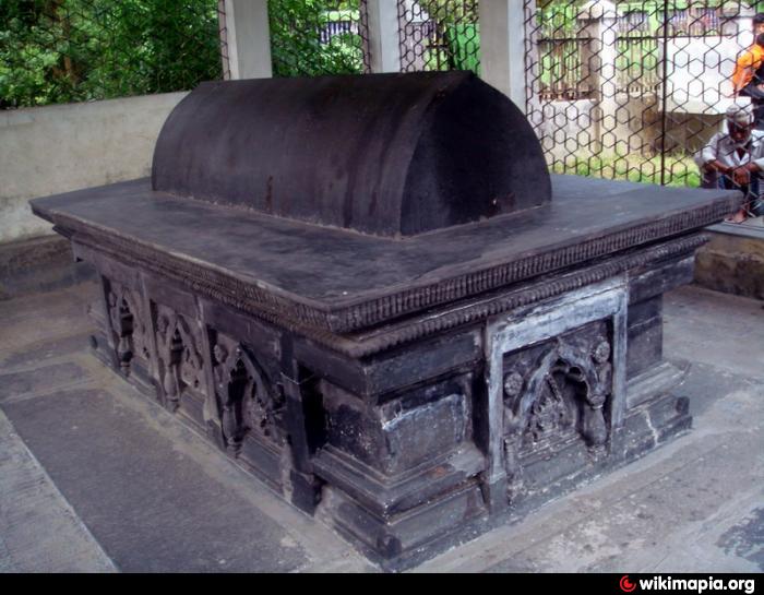
Archaeological heritage: Single dome mosque built by Jalaluddin Fath Shah (1489 AD), single dome mosque built by Alauddin Husain Shah (1522), tomb of Sultan Ghiyasuddin Azam Shah (1410 AD), tomb of Shah Langar (1422).
Historical events: The administrative centre of eastern Bengal under the Muslim rulers of Bengal survives at present in the name of an upazila in the Narayanganj district and the 'golden village' (its literal meaning) is now a township about 27 kilometers to the southeast of Dhaka. It is difficult to locate exactly the medieval city, but from the extant remains it appears to have embraced a wide tract bounded on the east, west and south by the Meghna, the Shitalakhya and the Dhaleshwari respectively and on the north by the Brahmaputra.
Sonargaon's importance in the pre-Muslim period is borne out by its ancient name of Suvarnagrama, from which it is obvious that the Muslim version of the name is derived. Langalband and Panchamighat, the two holy bathing places of the Hindus exist in this tract of land on the west bank of the old Brahmaputra. Suvarnavithi, mentioned in a 6th century land grant, the Ghugrahati copper-plate of Samacharadeva, has been taken to denote this area. With the Muslim occupation of the vanga area, Sonargaon continued to be the administrative centre of southeastern Bengal till the rise of Dhaka. The city continued to be important as a port and a mint town. Sonargaon rose to be the seat of an independent ruler under Ghiyasuddin Bahadur Shah, and after his fall it was the headquarters of the eastern province of Bengal under the Tughlaqs till 1338. Sonargaon emerged as the capital of an independent Sultanate under Fakhruddin Mubarak Shah (1338-1349) and his son Ikhtiyaruddin Ghazi Shah (1349-1352). It was a provincial metropolis except for a period when it became a capital city under the house of Isa Khan Masnad-i-Ala. After the fall of Musa Khan (1611), Sonargaon became one of the 'sarkars' of the Mughal subah of Bengal. With the establishment of the Mughal capital at Dhaka Sonargaon must have fallen fast into decay. In the late nineteenth and early twentieth century Panam-Nagar was developed in a part of medieval Sonargaon.
By the second quarter of the fourteenth century Sonargaon developed into a commercial metropolis; seafaring boats could easily reach Sonargaon from west Asian and southeast Asian countries. Ibn Batuta describes Sonargaon as an important port city which had direct commercial relations with countries like China, Indonesia (Java) and the Maldives. The Chinese envoy ma huan also found Sonargaon a great commercial metropolis. Hou hien (1415) describes it as a fortified walled city with tanks, streets, bazaars, and as an emporium of trade where all goods were collected and distributed. Ralph Fitch (1586) described it as a brisk commercial centre. 'Muslin' produced in Sonargaon, especially its finest variety called 'Khasa', had a worldwide reputation.
Sonargaon developed into a seat of Islamic learning under the versatile scholar Maulana Sharfuddin Abu Tawwamah of Bokhara who came to Sonargaon (sometime between 1282 and 1287) and established there a Khanqah and a Madrasa wherein all branches of Islamic learning as well as secular sciences were taught and studied. The present Dargahbari in Mograpara is possibly the site of that centre of learning.
From the extant archaeological remains it is evident that an extensive Muslim settlement had grown over the entire Mograpara and Goaldi region, and perhaps the Muslim capital city developed in and around Mograpara on the northern bank of the Menikhali river extending towards Goaldi and Baidyer Bazaar.
As of the 1991 Bangladesh census, Population 261881; male 52.11% and female 47.89%; Muslim 95.24% and Hindu 4.19%, others 0.57%.
Literacy and educational institutions: Average literacy 27.50%; male 42% and female 13%. Educational institutions: college 4, secondary school 6, community school 26, satellite school 9, government primary school 82, madrasa 10. Noted educational institutions: Mograpara HGGS Smriti Biddayatan (1934), Sonargaon GR Institution (1900).
Cultural organisations: Museum 1 Sonargaon Folk Arts Museum, rural club 26, cinema hall 6, theatre group 5, women's organisation 1, playground 19.
Religious institutions: Mosque 450, temple 35, tomb 10.
Main occupations: Agriculture 17.87%, agricultural labourer 17.61%, wages labourer 2.72%, fishing 3.02%, weaving 3.61%, industries 2.04%, transport 2.23%, commerce 20.6%, service 17.6%, others 12.7%.
Land use: Total agricultural land 14154.2 hectares, fallow land 999.6 hectares; single crop 14%, double crop 60% and treble crop land 26%. Land under irrigation 38%.
Land control: Among the peasants, 27% are landless, 60% small, 11% medium and 2% rich; cultivable land per head is 0.15 hectare.
Main crops: Paddy, potato, brinjal, patal, cauliflower, sugarcane and mula (radish).
Dairy, fishery and poultry Fishery 7, poultry 776, hatchery 2.
Transportation Roads: pucca 85 km. and mud road 200 km.
Extinct or nearly extinct transport: Palanquin, bullock cart, gaina boat, bajra boat.
Manufactories: Cement factory 3, paper mill 2, oil mill 1, textile mill 25, re-rolling steel mill 4.
Cottage industries: Weaving 948 (including jamdani), goldsmith 32, blacksmith 42, wood work 172 and bamboo & cane work 154.
Important exports: Industrial products, sari, cotton fabrics, vegetables.
NGO activities: Operationally important NGOs are brac, asa, proshika, VARC, POSD.
Health centres: Upazila health complex 1, family planning centre 11, satellite clinic 3.
The location of Sonargaon town is 23.6413533N 90.6036073E. Sonargaon (Town) consists of 6 mouzas. The area of the town is 0.73 sq km. It has a population of 4039; male 53.31%, female 46.69%. The literacy rate among the town people is 51%. The town has one dakbungalow.
Sonargaon thana was turned into a upazila in 1983. It consists 11 union parishads, 466 villages and 352 mouzas.
Archaeological heritage: Single dome mosque built by Jalaluddin Fath Shah (1489 AD), single dome mosque built by Alauddin Husain Shah (1522), tomb of Sultan Ghiyasuddin Azam Shah (1410 AD), tomb of Shah Langar (1422).
Historical events: The administrative centre of eastern Bengal under the Muslim rulers of Bengal survives at present in the name of an upazila in the Narayanganj district and the 'golden village' (its literal meaning) is now a township about 27 kilometers to the southeast of Dhaka. It is difficult to locate exactly the medieval city, but from the extant remains it appears to have embraced a wide tract bounded on the east, west and south by the Meghna, the Shitalakhya and the Dhaleshwari respectively and on the north by the Brahmaputra.
Sonargaon's importance in the pre-Muslim period is borne out by its ancient name of Suvarnagrama, from which it is obvious that the Muslim version of the name is derived. Langalband and Panchamighat, the two holy bathing places of the Hindus exist in this tract of land on the west bank of the old Brahmaputra. Suvarnavithi, mentioned in a 6th century land grant, the Ghugrahati copper-plate of Samacharadeva, has been taken to denote this area. With the Muslim occupation of the vanga area, Sonargaon continued to be the administrative centre of southeastern Bengal till the rise of Dhaka. The city continued to be important as a port and a mint town. Sonargaon rose to be the seat of an independent ruler under Ghiyasuddin Bahadur Shah, and after his fall it was the headquarters of the eastern province of Bengal under the Tughlaqs till 1338. Sonargaon emerged as the capital of an independent Sultanate under Fakhruddin Mubarak Shah (1338-1349) and his son Ikhtiyaruddin Ghazi Shah (1349-1352). It was a provincial metropolis except for a period when it became a capital city under the house of Isa Khan Masnad-i-Ala. After the fall of Musa Khan (1611), Sonargaon became one of the 'sarkars' of the Mughal subah of Bengal. With the establishment of the Mughal capital at Dhaka Sonargaon must have fallen fast into decay. In the late nineteenth and early twentieth century Panam-Nagar was developed in a part of medieval Sonargaon.
By the second quarter of the fourteenth century Sonargaon developed into a commercial metropolis; seafaring boats could easily reach Sonargaon from west Asian and southeast Asian countries. Ibn Batuta describes Sonargaon as an important port city which had direct commercial relations with countries like China, Indonesia (Java) and the Maldives. The Chinese envoy ma huan also found Sonargaon a great commercial metropolis. Hou hien (1415) describes it as a fortified walled city with tanks, streets, bazaars, and as an emporium of trade where all goods were collected and distributed. Ralph Fitch (1586) described it as a brisk commercial centre. 'Muslin' produced in Sonargaon, especially its finest variety called 'Khasa', had a worldwide reputation.
Sonargaon developed into a seat of Islamic learning under the versatile scholar Maulana Sharfuddin Abu Tawwamah of Bokhara who came to Sonargaon (sometime between 1282 and 1287) and established there a Khanqah and a Madrasa wherein all branches of Islamic learning as well as secular sciences were taught and studied. The present Dargahbari in Mograpara is possibly the site of that centre of learning.
From the extant archaeological remains it is evident that an extensive Muslim settlement had grown over the entire Mograpara and Goaldi region, and perhaps the Muslim capital city developed in and around Mograpara on the northern bank of the Menikhali river extending towards Goaldi and Baidyer Bazaar.
As of the 1991 Bangladesh census, Population 261881; male 52.11% and female 47.89%; Muslim 95.24% and Hindu 4.19%, others 0.57%.
Literacy and educational institutions: Average literacy 27.50%; male 42% and female 13%. Educational institutions: college 4, secondary school 6, community school 26, satellite school 9, government primary school 82, madrasa 10. Noted educational institutions: Mograpara HGGS Smriti Biddayatan (1934), Sonargaon GR Institution (1900).
Cultural organisations: Museum 1 Sonargaon Folk Arts Museum, rural club 26, cinema hall 6, theatre group 5, women's organisation 1, playground 19.
Religious institutions: Mosque 450, temple 35, tomb 10.
Main occupations: Agriculture 17.87%, agricultural labourer 17.61%, wages labourer 2.72%, fishing 3.02%, weaving 3.61%, industries 2.04%, transport 2.23%, commerce 20.6%, service 17.6%, others 12.7%.
Land use: Total agricultural land 14154.2 hectares, fallow land 999.6 hectares; single crop 14%, double crop 60% and treble crop land 26%. Land under irrigation 38%.
Land control: Among the peasants, 27% are landless, 60% small, 11% medium and 2% rich; cultivable land per head is 0.15 hectare.
Main crops: Paddy, potato, brinjal, patal, cauliflower, sugarcane and mula (radish).
Dairy, fishery and poultry Fishery 7, poultry 776, hatchery 2.
Transportation Roads: pucca 85 km. and mud road 200 km.
Extinct or nearly extinct transport: Palanquin, bullock cart, gaina boat, bajra boat.
Manufactories: Cement factory 3, paper mill 2, oil mill 1, textile mill 25, re-rolling steel mill 4.
Cottage industries: Weaving 948 (including jamdani), goldsmith 32, blacksmith 42, wood work 172 and bamboo & cane work 154.
Important exports: Industrial products, sari, cotton fabrics, vegetables.
NGO activities: Operationally important NGOs are brac, asa, proshika, VARC, POSD.
Health centres: Upazila health complex 1, family planning centre 11, satellite clinic 3.
Nearby cities:
Coordinates: 23°38'43"N 90°36'14"E
- Matlab Upazila (North) Area 16 km
- Rupganj Upazila 35 km
- Keraniganj Upazila 38 km
- Lohajang Upazila 40 km
- Kapashia Upazila 70 km
- Gafargaon Upazila 101 km
- Dhobaura Upazila 175 km
- Patiya Upazila (পটিয়া) 189 km
- Chandanaish Upazila 205 km
- Banshkhali Upazila (বাঁশখালী উপজেলা) 207 km
- Meghna Ghat (west) 3.1 km
- Megnaghat Power Plant Zone 4 km
- Meghna Ghat (east) 5.6 km
- Adamzee Jute Mills 8.9 km
- adamjee 9 km
- Merging of Dhaleshwari with Meghna 10 km
- paragon city development-rupgonj 10 km
- Sen Nagar 11 km
- Munshiganj Dist Town 14 km
- Dhaka Division 61 km