Kalvarija municipality
Lithuania /
Marijampoles /
Kalvarija /
World
/ Lithuania
/ Marijampoles
/ Kalvarija
World / Lithuania / Marijampoles
municipality, invisible, second-level administrative division
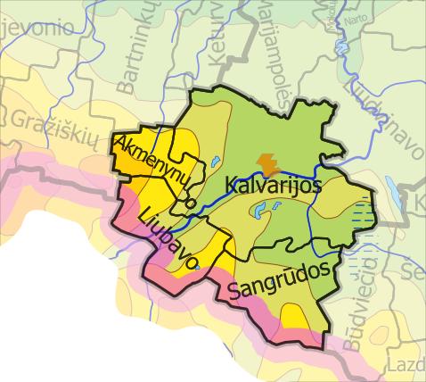
Located in southwestern Lithuania, borders with Poland. Covers area of 441 km². Divided into 4 elderships. Administrative centre and the biggest city is Kalvarija.
Municipality is located in Sūduva highlands, southern part is hilly, northern is flat. The longest river is Šešupė. Municipality dominated by agriculture. Via Baltica highway extended through the municipality.
www.kalvarija.lt/index.php?fuseaction=Home&langparam=EN
Municipality is located in Sūduva highlands, southern part is hilly, northern is flat. The longest river is Šešupė. Municipality dominated by agriculture. Via Baltica highway extended through the municipality.
www.kalvarija.lt/index.php?fuseaction=Home&langparam=EN
Wikipedia article: http://en.wikipedia.org/wiki/Kalvarija_municipality
Nearby cities:
Coordinates: 54°22'8"N 23°11'36"E
- Varėna district municipality 52 km
- Jurbarkas district municipality 128 km
- Vilnius district municipality 131 km
- Kėdainiai district municipality 134 km
- Kelmė district municipality 176 km
- Anykščiai district municipality 181 km
- Panevėžys district municipality 182 km
- Švenčionys district municipality 189 km
- Olevsk urban hromada 412 km
- Ivankiv Raion 550 km
- Kalvarija eldership 5.5 km
- Bartninkai eldership 19 km
- Gražiškiai eldership 20 km
- Marijampolė eldership 21 km
- Keturvalakiai eldership 22 km
- Vištytis regional park 28 km
- Pajevonys eldership 29 km
- Vištytis eldership 30 km
- Šeimena eldership 31 km
- Lower Nemunas plain 73 km