Anykščiai district municipality
Lithuania /
Utenos /
Anyksciai /
World
/ Lithuania
/ Utenos
/ Anyksciai
World / Lithuania / Vilniaus
municipality, invisible, second-level administrative division
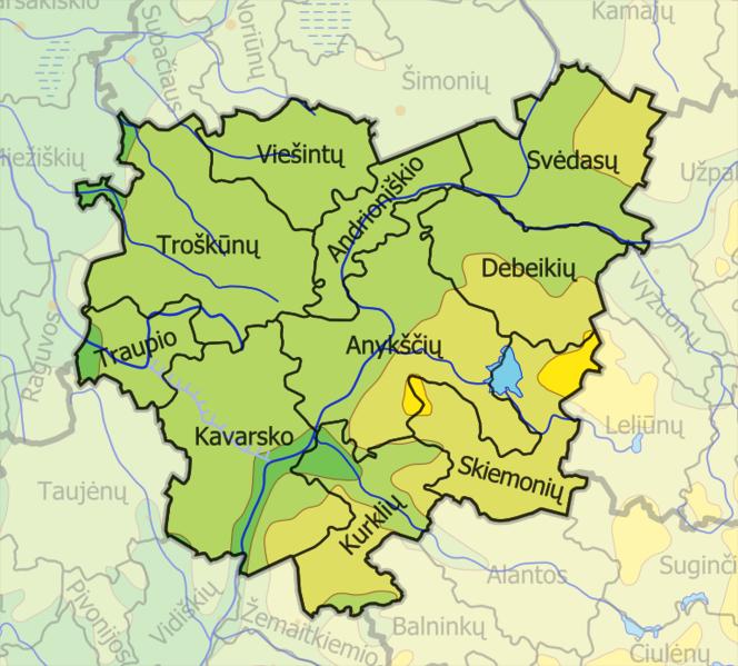
Located in northeastern part of Lithuania, covers area of 1765 km². Divided into 10 elderships. Administrative centre - Anykščiai, smaller cities are Kavarskas, Troškūnai.
Municipality lies in Aukštaičiai highlands, 30% of area is covered by forests, mostly by Šimonys Forest. The longest rivers are Šventoji, Anykšta, Nevėžis, Jara. Municipality is famous for Anykščiai regional park were people visit interesting places like Puntukas monument rock, take a ride by train which goes on tiniest rail in Europe. The highest church is located in Anykščiai, city is known for big amount of culture sites. Many lithuanian inteligents were born in Anykščiai surroundings.
www.anyksciai.lt/en/
Wikipedia article: http://en.wikipedia.org/wiki/Anykščiai_district_municipality
Nearby cities:
Coordinates: 55°32'17"N 25°4'51"E
- Anykščiai regional park 11 km
- Anykščių seniūnija 16 km
- Ukmergė district municipality 43 km
- Širvintos eldership 51 km
- Širvintos district municipality 54 km
- Šėta eldership 62 km
- Krekenava regional park 70 km
- Jonava district municipality 73 km
- Panevėžys district municipality 86 km
- Kėdainiai district municipality 99 km
- Anykščiai church of St. apostle evangelist Matthew 2 km
- Anykščiai marketplace 2.4 km
- Anykščiai Mindaugo karūnos Sports Complex 2.9 km
- Liudiškiai mound 4.7 km
- Didžioji Island 13 km
- Lake Rubikiai 13 km
- Kavarskas Reservoir 14 km
- Kavarskas eldership 15 km
- Šeriai Airfield 17 km
- Troškūnai eldership 18 km