Flood Rock (Former Site of Flood Rock/Great Mill Island)
USA /
New Jersey /
West New York /
World
/ USA
/ New Jersey
/ West New York
World / United States / New York
historical layer / disappeared object
Add category
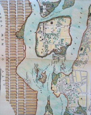
Flood Rock Island was the larger of two small islands in the middle of the East River's Hell Gate. First officially developed in 1701 by John Marsh, Flood Rock Island became known as Mill Island after Marsh built a sawmill and lumber works on the island. After Marsh's death, Great Mill Island squatted on by local farmer Sandy Gibson, who remained until both Great Mill and Little Mill Islands were seized by the Federal Government.
Developed as a US Army fort in advance of the War of 1812, Great Mill Island was equipped with a blockhouse and two cannons and was tasked along with several other forts along the East River of defending the Northern approaches to New York City from the Royal Navy. Remaining fortified but in decreasing use following the War of 1812 and through the Civil War, both Great Mill & Little Mill were soon deemed to be hazardous to the safe navigation of Hell Gate for sail & steam ships transiting the area.
Tasked with removing the more obstructive Great Mill Island from the navigable waters of the East River, the United States Army Corps of Engineers mined a tunnel from Queens beneath the East River to an area underneath Great Mill Island starting in 1885. After loading a subterranean chamber with roughly 300,000 lb (136,000 kg) of high explosives, Flood Rock/Great Mill Island ceased to exist On October 10, 1885, in what was the largest non-nuclear explosion in history (to that point). Reduced to largely a rubble pile by the explosion, the majority of what remained of Flood Rock/Great Mill Island were then used as fill around Little Mill Island and created what today is Mill Island.
Now little more than a scattered rockpile on the bottom of the East River, Flood Rock/Great Mill Island is still marked on USCG & NOAA charts as a deep-water hazard to navigation, but now lies out of the navigable water depth required of most vessels transiting Hell Gate.
Wikipedia article: http://en.wikipedia.org/wiki/Mill_Rock
Nearby cities:
Coordinates: 40°46'46"N 73°56'15"W
- American Society for the Prevention of the Cruelty to Animals - New York Chapter 0.6 km
- Gibbs Point 1.3 km
- Paramount Pictures Studios 2.6 km
- Long Island City (historic) 2.7 km
- Goldwater Memorial Hospital 3.1 km
- R Tower (relocated and demolished) 3.2 km
- East River Tennis Club 3.4 km
- City Hospital 3.4 km
- Former Amazon Long Island City Development Site 3.6 km
- Brooks Brothers Queens Factory 3.7 km
- Hell Gate 1.1 km
- Upper East Side 1.7 km
- Astoria 1.9 km
- Central Park 2.4 km
- Manhattan 2.8 km
- Upper West Side 3.4 km
- Midtown (Manhattan, NY) 5.2 km
- Western Queens 5.9 km
- Queens 15 km
- The Palisades 21 km