Huey P Long Bridge
USA /
Louisiana /
Port Allen /
World
/ USA
/ Louisiana
/ Port Allen
World / United States / Louisiana
bridge
Add category


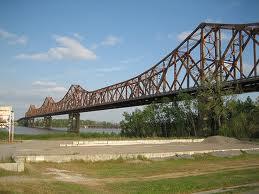


Built in 1936, the U.S. Highway 190 Mississippi River Bridge connects East Baton Rouge Parish (Baton Rouge, LA) with West Baton Rouge Parish (Port Allen, LA). This point marks the northern boundary of the deep water shipping channel of the Mississippi River and the Port of Baton Rouge.
In addition to motor vehicle traffic, the bridge is also traversed by a line of the Kansas City Southern Railway Company.
www.trains.com/TRC/CS/forums/535712/ShowPost.aspx
In addition to motor vehicle traffic, the bridge is also traversed by a line of the Kansas City Southern Railway Company.
www.trains.com/TRC/CS/forums/535712/ShowPost.aspx
Wikipedia article: http://en.wikipedia.org/wiki/Huey_P._Long_Bridge_(Baton_Rouge)
Nearby cities:
Coordinates: 30°30'24"N 91°11'58"W
- John James Audubon Bridge 29 km
- Atchafalaya Swamp Freeway 58 km
- Bonnet Carre Spillway Bridge (I-10) 90 km
- The Lake Pontchartrain Causeway 101 km
- Tx-21 Bridge over Toledo Bend Reservoir 267 km
- Texas Highway - 147 (Bridge) 310 km
- Fred Hartman Bridge 379 km
- US.Route 190 (Bridge) -- Onalaska Texas 381 km
- George & Cynthia Mitchell Memorial Causeway 382 km
- San Luis Pass-Vacek Toll Bridge 411 km
- Free Negro Point 1.3 km
- Anchorage, Louisiana 2.1 km
- Southern University and A&M College (SUBR) 2.2 km
- ExxonMobil Baton Rouge Refinery 3.1 km
- Sunrise, Louisiana 3.2 km
- Scotlandville 3.2 km
- Bayou Baton Rouge 4.1 km
- Thomas Point 5 km
- Devil's Swamp 5 km
- Lobdell, Louisiana 5.3 km
Comments