Lockheed D-21B Article 525 (Palmdale, California)
| aircraft, exposition, interesting place
USA /
California /
Palmdale /
Palmdale, California
World
/ USA
/ California
/ Palmdale
World / United States / California
aircraft, exposition, interesting place
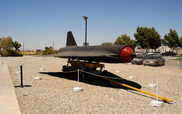
One of 38 examples of the D-21 Mach 3+ reconnaissance drone built for the USAF, this D-21 was designed to be launched from the back of a M-21 carrier aircraft, a variant of the A-12 Oxcart, and used for deep-penetration reconnaissance missions.
Wikipedia article: http://en.wikipedia.org/wiki/D-21_Tagboard
Nearby cities:
Coordinates: 34°36'10"N 118°5'8"W
- Means Dry Lake 145 km
- Six Spring Canyon 188 km
- Supersonic Low Level test area 189 km
- Olancha Dunes 190 km
- Little Dumont Dunes 202 km
- Deb Analog 202 km
- Rainbow Canyon / The Jedi Transition 203 km
- Devils Playground 205 km
- Val Jean Dunes 214 km
- Goodsprings, Nevada 276 km
- Palmdale Regional Airport/United States Air Force Plant 42 2.4 km
- Irrigated Fields 5.1 km
- Lake Los Angeles, California 23 km
- Rosamond Dry Lake 26 km
- Saddleback Butte State Park 27 km
- San Andreas Fault (Zone) 39 km
- Edwards Air Force Base 39 km
- Rogers Dry Lake 41 km
- Los Angeles County, California 43 km
- Edwards AFB Precision Impact Range Area (PIRA) 48 km