Goodsprings, Nevada
USA /
Nevada /
Goodsprings /
World
/ USA
/ Nevada
/ Goodsprings
World / United States / Nevada
unincorporated area / community, interesting place, CDP - Census Designated Place
Goodsprings was a settlement in the hills seven miles west of Jean. It served as an important town for milling or from the surrounding mines. This or would then be transported by wagon to Jean where it was loaded on trains. Today only a few landmarks are left.
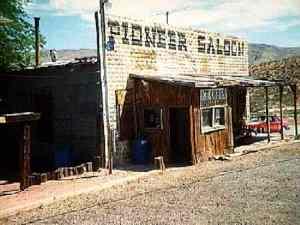
The town has named after a Mr. Joseph Good who headquartered his cattle raising operation there. At first the site was known as Good's Springs but eventually was called Goodsprings. It was a mining camp with a hotel, a saloon that is still standing and in operation, and a general store. The end of World War I also saw the end of Goodsprings as a mining town.
The town has named after a Mr. Joseph Good who headquartered his cattle raising operation there. At first the site was known as Good's Springs but eventually was called Goodsprings. It was a mining camp with a hotel, a saloon that is still standing and in operation, and a general store. The end of World War I also saw the end of Goodsprings as a mining town.
Wikipedia article: http://en.wikipedia.org/wiki/Goodsprings,_NV
Nearby cities:
Coordinates: 35°49'47"N 115°25'37"W
- Val Jean Dunes 67 km
- Little Dumont Dunes 80 km
- Devils Playground 98 km
- Deb Analog 130 km
- Six Spring Canyon 146 km
- Supersonic Low Level test area 177 km
- Means Dry Lake 186 km
- Rainbow Canyon / The Jedi Transition 202 km
- Olancha Dunes 236 km
- Ground Marking : Compass Rose (Aerial Aid-to-Navigation) 243 km
- Mesquite Dry Lake 19 km
- Sandy Valley, Nevada 20 km
- Lucy Gray Mountains 28 km
- Clark Mountain Range 34 km
- Ivanpah Lake 35 km
- Las Vegas, Nevada_duplicate 42 km
- Kingston Range 45 km
- Charleston View, California 45 km
- Pahrump, Nevada 71 km
- Mojave National Preserve 82 km
Comments