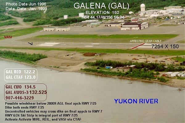
Edward G. Pitka Sr Airport (Former Galena Air Force Station) (Galena, AK)
USA /
Alaska /
Galena /
Galena, AK
World
/ USA
/ Alaska
/ Galena
World / United States / Alaska
airport
Add category
FAA Identifier: GAL - www.airnav.com/airport/PAGA
Former Galena Air Force Station, which housed intercept fighter squadrons from the 1940's through 1993. The base was proposed to be decommissioned in 2005, and is being turned over to the state of Alaska and the city of Galena.
Plan for Galena's re-use of the former Galena Air Force Station: (PDF) galena.iialaska.com/docs/planFINAL.pdfnnAnnotated aerial imagery: www.alaska.faa.gov/fai/airports.htm#LowerYukon
Wikipedia article: http://en.wikipedia.org/wiki/Edward_G._Pitka_Sr._Airport
Nearby cities:
Coordinates: 64°44'21"N 156°55'52"W
- Fairbanks International Airport (FAI) 428 km
- Fort Wainwright Airfield / Ladd Army Airfield (PAFB) 440 km
- Eielson Air Force Base, AK (EIL/PAEI) 463 km
- Elmendorf Air Force Base (EDF/PAED) 521 km
- Ted Stevens Anchorage International Airport (ANC/PANC) 525 km
- Allen Army Airfield (Fort Greely) 544 km
- Kenai Municipal Airport 545 km
- King Salmon Airport 673 km
- Tanacross Airport (TSG) 677 km
- Yakutat Airport (PAYA) 1064 km
- Guy Grieve's approx camp 25 km
- Old mining operation 89 km
- Koyukuk Wilderness 104 km
- Yukon - Nowitna Confluence 127 km
- Indian Mountain Long-Range Radar Site (LRRS), Alaska 208 km
- Leonard Island, Alaska 230 km
- Long Island 233 km
- pulau tanana 235 km
- Yukon - Tanana Confluence 238 km
- Lake Todatonten 242 km