Indian Mountain Long-Range Radar Site (LRRS), Alaska
USA /
Alaska /
Hughes /
World
/ USA
/ Alaska
/ Hughes
World / United States / Alaska
military, United States Air Force, early warning radar

Indian Mountain LRRS was one of the two ground controlled intercept sites added to the 10 original AC&W sites constructed as part of the establishment of a permanent air defense system in Alaska during the early 1950s. The site operated as part of the Alaska Radar System and manned by the 708th Aircraft Control and Warning Squadron through 1983, when the radar system was replaced with a single AN/FPS-117 minimally attended radar system at the top camp. Indian Mountain was one of the original sites in the tropo system, in conjunction with smaller microwave antennae sites which formed the White Alice Communications System (WACS). The site's two 30ft parabolic dishes connected the station to the rest of the WACS system via a 75 mile shot to the Bear Creek WACS station to the Southeast.
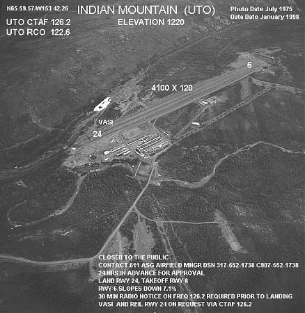
The location of Indian Mountain made construction a challenge. Military engineer construction personnel were used to build a 9.1 mile road to the top of the mountain connecting an upper and lower camp. The lower camp, located at the confluence of the Indian River and Utopia Creek, included a runway with a 12-percent slope, the steepest remote site runway. The upper camp, at the summit of Indian Mountain (elevation 4,234 feet), could be reached by the road.
Following the end of manned operations at the site, many of the buildings at the Indian Mountain Air Force Station were left idle until their demolition as part of sitewide environmental remediation efforts during "Operation Clean Sweep". TOday the only remaining buildings are used for the storage of materials used to support the unmanned radar site at the top camp.
radomes.org/museum/showsite.php?site=Indian+Mountain+AF...
www.afcee.brooks.af.mil/ec/eiap/nepa/IndianMountain/FER...
Topo: www.topozone.com/map.asp?lat=66.06917&lon=-153.68667&da...
Wikipedia article: https://en.wikipedia.org/wiki/Indian_Mountain_Air_Force_Station
Nearby cities:
Coordinates: 66°1'51"N 153°40'49"W
- Clear Air Force Station 281 km
- Fort Wainwright 304 km
- Blair Lake Air Force Range, AK 329 km
- Eielson Air Force Base, AK (EIL/PAEI) 333 km
- Donnelly Training Area, AK 413 km
- Fort Greely Missile Defense Command Base 433 km
- Gerstle River Arctic Test Site 464 km
- Fort Richardson 547 km
- Elmendorf Air Force Base (EDF/PAED) 558 km
- Fort Richardson Army Base 560 km
- Lake Todatonten 36 km
- Leonard Island, Alaska 121 km
- Long Island 121 km
- Yukon - Tanana Confluence 124 km
- pulau tanana 124 km
- Yukon - Nowitna Confluence 126 km
- Huslia, AK Airport 127 km
- Koyukuk Wilderness 174 km
- Edward G. Pitka Sr Airport (Former Galena Air Force Station) 208 km
- Guy Grieve's approx camp 225 km
Comments