Gohpur Town (Gohpur)
India /
Assam /
Gohpur
World
/ India
/ Assam
/ Gohpur
World / India / Assam / Sonitpur
township
Add category
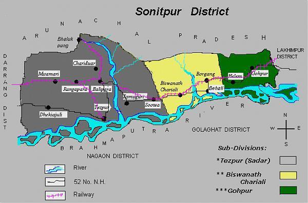
Gohpur is a sub-division of Sonitpur district in the Indian state of Assam.
Boundaries:-
East- Lakhimpur District
West- Biswanath Sub division of Sonitpur District
South- Brahmaputra River
North- Arunachal Pradesh
It is located at 26.88° N 93.63° E[1]. It has an average elevation of 69 metres (226 feet).
As of 2001 India census[2], Gohpur had a population of 9408. Males constitute 53% of the population and females 47%. Gohpur has an average literacy rate of 72%, higher than the national average of 59.5%: male literacy is 77%, and female literacy is 66%. In Gohpur, 13% of the population is under 6 years of age.
Nearby cities:
Coordinates: 26°52'55"N 93°36'48"E
- Shahbazpur Town 398 km
- Kachua Upazila HQ 479 km
- Manikchari Upazila HQ 482 km
- Kaptai Upazila HQ 506 km
- Sandwip Upazila HQ 533 km
- Kamalnagar Upazila HQ 536 km
- Ramgati Upazila HQ 542 km
- Betagi Upazila HQ 607 km
- Mirzaganj Upazila HQ 609 km
- Kathalia Upazila HQ 609 km
- Gohpur Tea Estate 3 km
- New Ghagra Tea Eastate 3.3 km
- Nirmala Tea Estate 10 km
- Itanagar Airport 10 km
- Brhamajan Tea Estate 10 km
- DUFFLAGHUR tea Estate 13 km
- Vivekananda Kendra Vidylaya Balijan 14 km
- Simaluguri, North Lakhimpur, Assam 16 km
- R. Subansiri Confluence1 24 km
- Kaziranga National Park 37 km