Kaptai Upazila HQ
Bangladesh /
Rangamati /
Kaptai /
World
/ Bangladesh
/ Rangamati
/ Kaptai
World / Bangladesh / Chittagong / Rangamati / Parbattya Chattagram
hills, township, hydroelectric power station/plant, subdistrict, fourth-level administrative division, local government
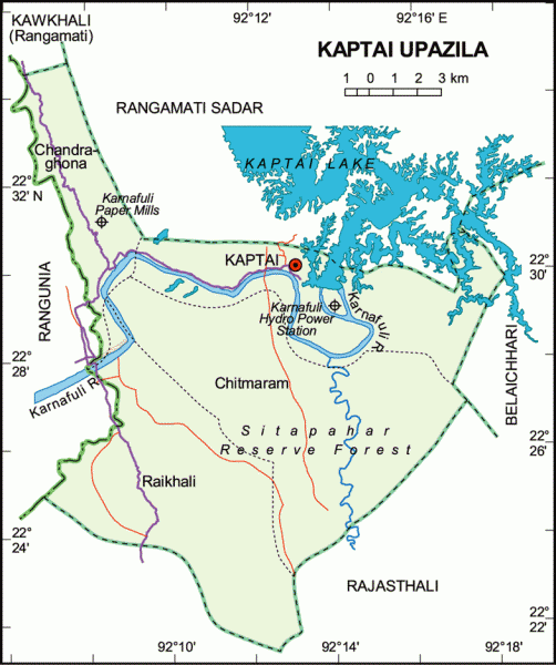
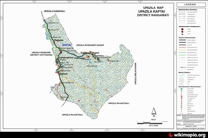
Kaptai Upazila (Rangamati district) with an area of 259 sq km, is bounded by Rangamati sadar and Kawkhali (Rangamati) upazilas and Kaptai Lake on the north, Rajasthali upazila on the south, Belaichhari and Rajasthali upazilas on the east, Rangunia upazila on the west. Main river is Karnafuli; Kaptai lake is notable.
The Kaptai Dam on Karnafully river here, built in 1950's by UTAH Inc. notably for Hydroelectric Power (the only Hydro-electric power plant of Bangladesh) is the largest man-made dam in Bangladesh. This created the Kaptai Lake.
The location of Kaptai town is 22.4837968N 92.1936607E. Kaptai (Town) consists of two mouzas. The area of the town is 126.91 sq km. The town has a population of 37720; male 57%, female 43%. Literacy rate among the town people is 25.5%. The town has one dakbungalow.
Kaptai thana was established in 1976 and was turned into an upazila in 1985. It consists of 4 union parishads, 9 mouzas and 144 villages.
As of the 2001 Bangladesh census, Kaptai had a population of 66,135. Males constituted 55.45% of the population, and females 44.55%. Upazila's eighteen up population is 32,352. Muslim 62.78%, Hindu 5.95%, Buddhist 30.49%, Christian 0.69% and others 0.09%.
Literacy and educational institutions: Average literacy 22.8%; male 28.7% and female 13.6%. Educational institutions: college 1, high school 5, technical school 1, primary school 100.
Main occupations: Agriculture 14.89%, agricultural labourer 5.82%, wage labourer 3.12%, commerce 7.62%, service 26.08%, forestry 2.4%, industry 26.24% and others 13.83%.
Land use: Forestry 188.06 sq km, cultivable and residential land 70.94 sq km.
Land control: Absolute land ownership belongs to the state; but public enjoy the right on the basis of possession.
Main crops Paddy, hilly potato, cotton, ginger, and vegetables.
Main fruits Jackfruit, banana, pineapple, coconut, lemon.
Manufactories: Chandraghana Paper Mill, Rayon Industry, Kaptai Hydro-Electric Project.
Health centres: Upazila health complex 1, kaptai project hospital, christian missionary hospital.
Nearby cities:
Coordinates: 22°29'47"N 92°12'58"E
- Chandanaish Upazila 37 km
- Patiya Upazila (পটিয়া) 46 km
- Banshkhali Upazila (বাঁশখালী উপজেলা) 52 km
- Matlab Upazila (North) Area 203 km
- Lohajang Upazila 235 km
- Rupganj Upazila 236 km
- Keraniganj Upazila 245 km
- Kapashia Upazila 265 km
- Gafargaon Upazila 290 km
- Dhobaura Upazila 356 km
- Kaptai Dam & Hydro Power Plant 1.2 km
- Shaheed Moazzam 3 km
- Wagga Chara Tea Garden 7.4 km
- CHANDRAGHONA, Rangunia-Kaptai 10 km
- Kaptai Lake (কাপ্তাই লেক) 20 km
- Boalkhali Upazilla 26 km
- Rangamati District 34 km
- Chattogram District Area 44 km
- Bandarban District 82 km
- Mizoram 105 km