Shahbazpur Town
Bangladesh /
Brahman Bariya /
Sarail /
World
/ Bangladesh
/ Brahman Bariya
/ Sarail
World / Bangladesh / Chittagong / Comilla / Brahmanbaria
city, town, village, township, region, fourth-level administrative division, local government, region (administrative division)
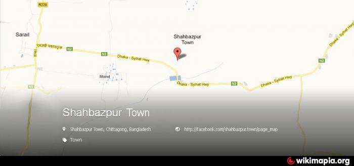
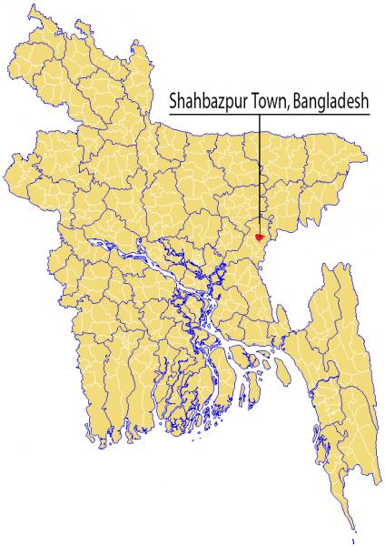
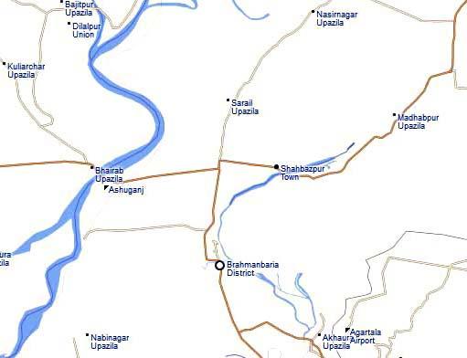

'''Shahbazpur Town''' (Bengali: শাহবাজপুর টাউন) is a town/nagar union in Brahmanbaria District in the Comilla Division of eastern Bangladesh. It was part of greater Chittagong Division until 2015. It consists of a self-governing town and It has 1 union parishad, 6 mouzas and 17 villages. Its geographical coordinates are 24° 3′ 6″ North, 91° 10′ 24″ East and its original old name (with diacritics) is Shāhbāzpur.
==Geography==
Shahbazpur Town is located at 24.051667°N 91.173333°E. It has 17958 units of house hold and total area 26.9 km².
==Demographics==
As of the 1991 Bangladesh census, Shahbazpur Town has a population of 1,35,288. Males constitute 50.27% of the population, and females 49.73%. This towns's eighteen up population is 40,746. Shahbazpur Town has an average literacy rate of 74% (7+ years), and the national average of 82% literate.
==Administrative==
Shahbazpur Town has 1 Unions/Wards, 6 Mauzas/Mahallas, and 17 villages. List of unions villages and other areas of this town.
* Shahbazpur Town Nagar Union (Union Council)
* Bolurampur (Village)
* Khomutapur (Village)
* Shahbazpur (Village)
* Rajamarakandi (Village)
* Tumontur (Village)
* Jadubpur (Village)
* North Dithpur (Village)
* South Dithpur (Village)
* Nismontupur (Village)
* Voishamura (Village). etc
* Titas Nadirpar (River)
* Shapla beel (lake)
* Madrasha Bazar, 2nd Gate (main town area)
* Khan Market (main town area)
* Arot Bazar (port area)
* Dhaka-Sylhet Highway (road)
* Titas River, Bridge Side (port area)
* Titas Bridge/also known as Shahbazpur Shetu (bridge)
* Shahbazpur Highway Police Station (Police Station)
* 1st Gate, Post Office Para (Post Office). etc
== People ==
Majority of people living here are Muslims, and also Hindus. The main occupation of people here is businesses, agriculture as this area is highly fertile. The population of the Shahbazpur Town is around 35,288 (50.27% male, 49.73% female), with the literacy rate of 82%. It needs to mentioned that Shahbazpur M.L. High School, Shahbazpur Girls High School and Shahbazpur Darul Ulum Madrasah were established in 1907, 2000 and 1886 respectively
== Connectivity ==
The Shahbazpur Town is directly connected to Asian-Highway road, attach to Titas River. etc
== External links ==
* [ goo.gl/maps/S30YK Google Maps ]
* [ goo.gl/pchm2H Road Connected Map ]
* [ goo.gl/W2BqT3 Facebook Place ]
[[Category:Populated places in the Chittagong Division]]
[[Category:Towns of Bangladesh]]
{{bangladesh-geo-stub}}
Wikipedia article: http://en.wikipedia.org/wiki/Shahbazpur_Town
Nearby cities:
Coordinates: 24°2'9"N 91°11'43"E
- Rupganj Upazila 67 km
- Kapashia Upazila 77 km
- Matlab Upazila (North) Area 87 km
- Gafargaon Upazila 94 km
- Keraniganj Upazila 101 km
- Lohajang Upazila 113 km
- Dhobaura Upazila 155 km
- Patiya Upazila (পটিয়া) 197 km
- Chandanaish Upazila 210 km
- Banshkhali Upazila (বাঁশখালী উপজেলা) 217 km
- BSCIC- Brahmanbaria 8.4 km
- East Medda 10 km
- Brahmanbaria District City 11 km
- Civic Zone 12 km
- korilla khal, excavated by AZM Obaidullah Khan the then commisioner Chittagong Division 13 km
- Agartala Airport 17 km
- Habigonj District 45 km
- Tripura 71 km
- Sylhet Division 83 km
- Dhaka Division 87 km
Comments