Point Reyes Weather Station (site)
USA /
California /
Inverness /
Sir Francis Drake Boulevard
World
/ USA
/ California
/ Inverness
World / United States / California
panoramic view, interesting place, weather / meteorological station
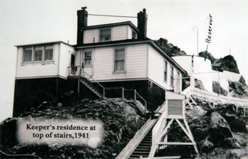
In 1901, the Weather Bureau built a station at the head of the stairs leading to the lighthouse. Storm warning flags were flown from the summit of the point to alert mariners of approaching foul weather. The Life-saving Service opened a station on Point Reyes Beach, just two and one-half miles north of the lighthouse, in 1890. This station was in operation until the Coast Guard opened a lifeboat station on Drake’s Bay in 1927. That same year, modern communications eliminated the need for the weather station at Point Reyes, and the building was subsequently used as a dwelling by the lightkeepers.
The site of the weather station is now a platform with benches.
www.lighthousefriends.com/light.asp?ID=66
The site of the weather station is now a platform with benches.
www.lighthousefriends.com/light.asp?ID=66
Nearby cities:
Coordinates: 37°59'47"N 123°1'15"W
- Skywalker Ranch 31 km
- Hamilton Army Airfield Site 44 km
- Old Town Sausalito 49 km
- Fort Winfield Scott 51 km
- Point Richmond, California 55 km
- Fisherman's Wharf 56 km
- Mission Bay 59 km
- Shone Farm - former Military/CIA site 59 km
- Safari West 69 km
- Petrified Forest Park 71 km
- Drake's Bay 7.9 km
- Point Reyes National Seashore 16 km
- San Andreas Fault Zone (approx.) 20 km
- Duxbury Reef 29 km
- Kent Lake 30 km
- Farallon Islands 30 km
- Bolinas, California 30 km
- Bolinas Lagoon 32 km
- Bolinas Bay 33 km
- Mount Tamalpais Watershed 33 km