Cortez Pit
USA /
Nevada /
Battle Mountain /
World
/ USA
/ Nevada
/ Battle Mountain
mine, open-pit mine, gold mine
www.barrick.com/operations/north-america/cortez/default...
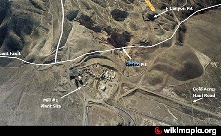
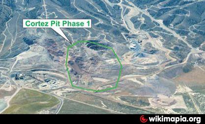
This is one of the pit that mined the Cortez Deposit and was discovered in the 1966. Barrick has planned for an extension of the pit to the west as part of the Phase 1 project for the Cortez pit (see attached image).
The US Geological Survey found anomalous gold in altered outcrops at the base of the Cortez Range in 1966.The CJV shortly afterwards discovered the Cortez deposit. Production at Cortez began in 1969 and continued until 1972, and then resumed from 1988 to 1993. Production was from the F-Canyon, Cortez and Ada 52 pits. Waste dumps from the operations were reclaimed during the 1990s. The Cortez process facilities include three inactive heap leach pads, West, East and 91-C leach pads, constructed in 1972, 1984 and 1990 respectively. The leach pads have been inactive since 1994. Seven tailings storage areas are situated in the Cortez area, TA 1 to TA 7, inclusive.
Wikipedia article: http://en.wikipedia.org/wiki/Cortez_Gold_Mine
Nearby cities:
Coordinates: 40°11'39"N 116°36'58"W
- Mount Hope Project 54 km
- Marigold Mine Property Boundary 85 km
- Bingham Canyon Copper Mine 379 km
- Fossil Butte National Monument 523 km
- Bagdad copper mine 687 km
- Freeport McMoRan Morenci Mine 1014 km
- Chino Copper Mine 1115 km
- Minago Property 2023 km
- Hull-Rust-Mahoning Open Pit Iron Mine 2050 km
- Three Oaks Coal Mine 2060 km
- CHOP Waste Rock Facility 3.2 km
- Cortez Mine Operations Permit Area 6.1 km
- Area 34 Heap Leach Facility 6.3 km
- Pipeline Waste Rock Dump 7.8 km
- Area 30 Heap Leach Facility 10 km
- Crescent Valley 25 km
- Grass Valley 35 km
- Tonkin Springs Mine 36 km
- Pinion Gold Project 60 km
- Diamond Valley 68 km