Northfield (Birmingham)
United Kingdom /
England /
Barnt Green /
Birmingham
World
/ United Kingdom
/ England
/ Barnt Green
World / United Kingdom / England
district, draw only border


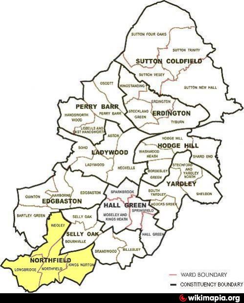
Northfield is a residential area on the very southern outskirts of the City of Birmingham, central England on the boundary with northern Worcestershire. It is also a UK Parliamentary constituency and a City council constituency district, managed by its own district committee. The constituency includes the City electoral wards of Kings Norton, Longbridge, Weoley and the smaller ward of Northfield that includes West Heath and Turves Green (see outline map above).
Mentioned in the Domesday Book and formerly a small village, then included in north Worcestershire, Northfield only became part of Birmingham in 1919 after it had been rapidly expanded and developed in the period prior to World War I. The northern reaches of Northfield fall just short of the Bournville model village and the southern housing estates were originally built by Austin Motors for their workforce.
A centre of the Midlands nail making industry during the 19th century and home to both the Kalamazoo paper factory and the Austin motor company’s Longbridge factory in the 20th century, today Northfield is predominantly a residential and dormitory suburb for metropolitan Birmingham. Northfield stands on either side of the main A38, heading south from the centre of Birmingham to Bromsgrove and onwards all the way to Cornwall.
Communities and neighbourhoods (in whole or in part) within the district include: Weoley Castle, Shenley Fields, King's Norton, Walker's Heath, West Heath, Hawkesley, Turves Green, Longbridge, Rednal and Frankley.
for information on the history of Northfield see @:
birmingham.gov.uk/cs/Satellite?c=Page&childpagename=Lib...
for more information on the District and available services see constituency district profile @:
www.birmingham.gov.uk/northfield
for large-scale online detailed map from Birmingham C.C. used in drawing attached polygon @:
localview.birmingham.gov.uk/My_Local_Information/Sites/...
Wikipedia article: http://en.wikipedia.org/wiki/Northfield,_Birmingham
Nearby cities:
Coordinates: 52°24'46"N 1°58'24"W
- Selly Oak 4.2 km
- Hall Green 7.7 km
- Edgbaston 8.3 km
- Redditch 10 km
- Halesowen 12 km
- Rowley Regis 13 km
- Wycombe District 99 km
- Pontypridd 130 km
- Beckenham 170 km
- North Devon 204 km
- Ley Hill Recreation Ground 1.1 km
- Austin Village Conservation Area 1.3 km
- Manor Farm Park 1.5 km
- Shenley Academy grounds 1.8 km
- West Heath Park 1.9 km
- Bournville Tennants Conservation Area 1.9 km
- Rowheath Playing Fields 2.4 km
- Bournville 2.6 km
- Kings Norton Park 2.8 km
- Bournville Village Conservation Area 3.2 km