Road Stub (Washington, D.C.)
USA /
District of Columbia /
Washington /
Washington, D.C.
World
/ USA
/ District of Columbia
/ Washington
World / United States / District of Columbia
street
Add category
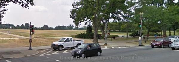
Here are visible the street-corner traces of the former road (in line with 16th Street north of Lafayette Park) which connected the former Washington Monument parking area (removed for security and landscaping reasons) and Constitution Ave. A remnant of the former road surface is patterned-over with "no parking" stripes. Official vehicles use the area as a parking space and access point to the Washington Monument-area lawns which can still be reached from here beyond the German American Friendship Garden plantings.
Nearby cities:
Coordinates: 38°53'31"N 77°2'11"W
- Historic Downtown Laurel - Main Street 29 km
- Oldtown Manassas 41 km
- West Baltimore Brick Paved Streets 55 km
- Log Cabin Road 151 km
- Austin St. and Continental Ave. (Forest Hills Shopping District) 340 km
- Alley Pond Environmental Center (APEC) 349 km
- Nassau Boulevard(Former NY 25D) 352 km
- Horton Road 396 km
- Clematis Street 1385 km
- Middle Street 4042 km
- The National Mall 0.6 km
- Constitution Gardens 0.7 km
- West Potomac Park 0.8 km
- Tidal Basin 0.9 km
- 14th Street Bridge Complex 1.9 km
- Lady Bird Johnson Park 1.9 km
- Pentagon River Entrance Satellite Parking Lot 2.3 km
- Interstate 395 Exit 9-10 2.3 km
- Pentagon Complex 2.6 km
- Arlington County, Virginia 5.8 km