Maulvibazar District Town
Bangladesh /
Maulvi Bazar /
World
/ Bangladesh
/ Maulvi Bazar
/ Maulvi Bazar
World / Bangladesh / Sylhet / Sylhet / Moulvibazar
third-level administrative division
Add category


Maulvi Bazar District (Sylhet division) with an area of 2799.39 sq km, is bounded by Sylhet district on the north, Tripura state of India on the south, Assam and Tripura states of India on the east, and Habiganj district on the west. The main rivers of the district are the Manu, the Dholoi and the Juri which flow from India; noted depressions: Hakaluki, Hail and Kawadighi Haors. Annual temperature: maximum 33.2°C, minimum 13.6°C; annual rainfall 3334 mm. The total forest area is 413.65 sq km (about 15% of the total area of the district); noted forest ranges are Patharia, Sanrer Gaz or Longla, Rajkandi and Vanugachh.
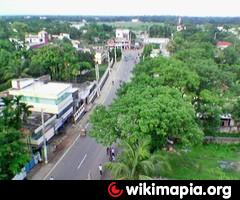
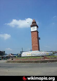
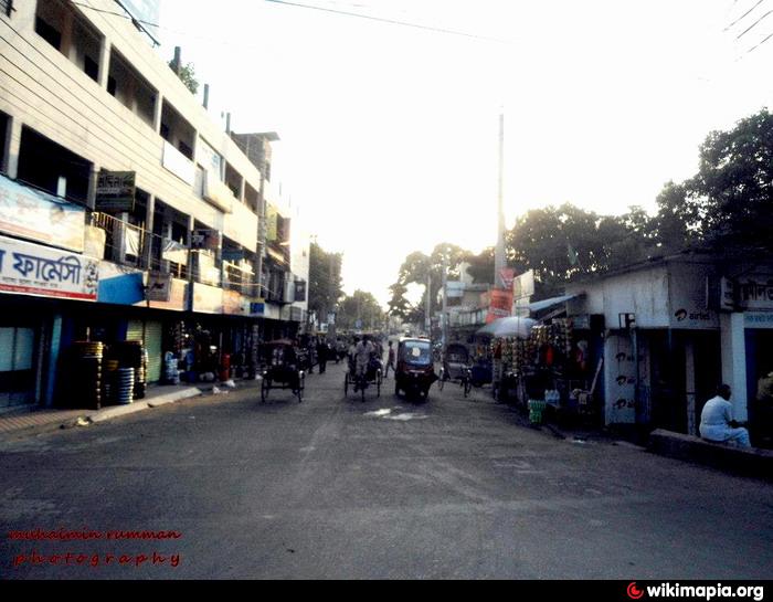
The geographic location of Moulvi Bazar town centre is 24.4830432N 91.7771673E. Maulvi Bazar (Town) stands on the bank of the River Manu. It consists of 9 wards and 47 mahallas. It has an area of 10.36 sq km; population 41358; male 54.97%, female 45.03%; density of population is 3992 per sq km. Literacy rate among the town people is 56.7%. Maulvi Bazar Municipality was established in 1930. The town has one Circuit House and one Rest House; Pashchim Bazar and Chowmuhana are the main commercial centres.
Maulvi Bazar subdivision was established in 1960 and was turned into a district in 1984. It consists of 6 upazilas, 4 municipalities, 36 wards and 123 mahallas, 66 union parishads, 876 mouzas, 2030 villages. The upazilas are barlekha, kamalganj, kulaura, maulvi bazar sadar, rajnagar and sreemangal.
Archaeological heritage: Khoja Mosque of Laghati village in Dasher Bazar (Barlekha, 16th century), Madhab Mandir located near the Madhabkunda water fall,Hum Hum at Kamalgonj Upozila,Nawab Bari of Pritthim Pasha (first quarter of 18th century),Ranir Dhigi,Soisirir Dhighi, Khoja Mosque (14th century, Goiyghar), the temple of Agnian Thakur, Nirmmai Shib-Bari (1454), Gaiyebi Eter Masjid at the premises of the tomb of Kazi Khandker (R), Persian manuscripts of Firoz Shah Tuglak's period (1330 AD).
Historical events: A battle between the Pathan warrior Khawasa Osman and Raja Subidha Narayan was fought in 1595 at Rajnagar. During the sepoy revolt, in 1857 some 300 sepoys looted the Chittagong Treasury and took shelter to Gaus Ali Khan, zamindar of Pritthim Pasha.
Religious institutions: Mosque 1935, temple 419, church and pagoda 57, sacred place 2, mazar 16.
As of the 1991 Bangladesh census, Population 1604028; male 50.11%, female 49.89%; Muslim 70.59%, Hindu 28.31%, Christian 0.92%, Buddhist 0.04%, others 0.14%. Ethnic nationals: Manipuri, Khasi, Tripura, Halam; of these group have their own languages.
Literacy and educational institutions: Average literacy 30.8%; male 36.8%, female 24.6%. Educational institutions: college 21, secondary school 123, primary school 1078, madrasa 108, co operative institute 1, youth training centre 1, nursing institute 1, vocational training institute 1, Tea Research Institute 1, horticulture research institute 1, primary training institute 1, education project for the blinds (government) 1.
Cultural organisations: Club 156, cinema hall 10, public library 9, community centre 10, jatra party 4, social welfare organisation 207, shishu sadan (Children's home) 14, shishu academy 1, shilpakala academy 1.
Main occupations: Agriculture 31.21%, fishing 2.6%, industry 3.61%, transport 1.66%, agricultural labourer 15.01%, wage labourer 10.58%, commerce 9.12%, service 9.73% and others 16.48%. Many people of this district are working in UK, USA, Middle East and other countries of the world.
Land use: Arable land 175229 hectares; single cropping 32.92%, double crop 58.58% and triple crop 8.50%; tea gardens 291.26 sq km; land under irrigation 160.77 sq km.
Land control: Among the peasants 16.99% are landless, 20.63% marginal, 36.60% small, 20.10% intermediate and 5.68% rich.
Main crops Aush, aman and boro paddy, arum, til (sesame), tea, rubber, betel leaf, betel nut.
Fisheries, dairies, poultries Dairy 120, poultry 126, fishery 128, hatchery 13.
Communication facilities- Roads: pucca 832.28 km, mud road 3610.44 km; rail station 18, railway junction 1; airport 1 (Shamshernagar, now abandon);Air strip - 1 (Balishira Club) , riverport 1 (Sherpur).
Manufactories: Among the 153 tea gardens of the country 90 are situated in this district; these tea gardens produce about 64% of the national tea production.
Cottage industries: Agarbati and attar (essence of flowers) of Baralekha are exported to Middle East and Fareast countries; other most notable cottage industries Manipuri weaving, bamboo and cane work, shital pati etc; total number of small and cottage industries is about 5500.
Mineral resources: coal, glass sand and lignite have been found in Maulvi Bazar and Patharia. There is possibility of exploring petroleum and natural gas.
NGO activities: CARE, brac, asa, caritas, Unnaiyan Sahaiyak Sangsta (USS), FIVDB, Sahaiyata, AUS, Janakollan Kendra, Meristops, PAUK, Nari Pragati, Agragami Mahila Samiti, Pratishruti.
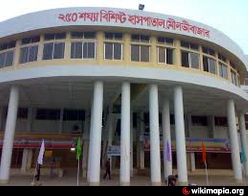
Health centers: District sadar hospital 1, upazila health center 6, satellite clinic 14, union and rural health center 20, family welfare center 37, maternity and child care center 1, 250-bed hospital 1, TB clinic 1, eye hospital 1, missionary hospital 4, diabetic hospital 1, police hospital 1, under 5 Clinic 1, prison hospital 1, charitable dispensary 9. Tea labor hospital - 1
Economy: The main exports of Maulvi Bazar are bamboo, tea, pineapple, cane,fish, jackfruit, oranges, agar, silica (Quartz) sand,rubber, mangoes and lemons. Ninety-one of Bangladesh's 153 tea gardens are located in Moulvi Bazar. The area is also home to the three largest tea gardens (size and production wise) in the world. Pineapples from the Sreemangal area are famous for their flavour and natural sweetness. Sreemongal is known as the 'tea capital of Bangladesh' due to the high frequency of tea plantations found there.
The physiography of the region was seriously changed due to the earthquake of 12 July 1897. Islam was brought to the area hundreds of years ago by the famous Muslim Saint, Hazrat Shah Jalal (RA). The Shrine of Hazrat Shah Mustafa (RA) a companion of the greatest saint Hazrat Shah Jalal (RA) is located in Moulvibazar town. Originally, with the advent of a saint Hazrat, Syed Shah Mustafa Sher-E-Sowar Chabukmar Baghdadi (RA) for preaching Islam, Moulvibazar became famous. Moulvibazar got its name from one of the descendents of Hazrat Shah Mustafa,who was preaching there as a maulavi there.
Places of interest: The shrine of Shah Mustafa, a companion of Shah Jalal, the man who brought Islam into this area. It is also home to many tea plantations. Maulvi Bazar town now has a shopping mall and several Indian, Chinese and American eateries. Madhabkunda waterfall is one of the enchanting place in Barlekha,Hum Hum Waterfall at Kamalgonj a newly found nature's beauty, 'Hakaluki Haor',Haail Haor'Madhobpur Lake', 'Bilashchhara Lake', 'Lawachara National Park' in Kamalganj upazilla are other places of interest in the district. 'Lawachara National Park' in Kamalganj is a major national park and nature reserve in Bangladesh. The park is located at Kamalganj Upazila. The Park covers approximately 1,250 ha (12.5 km2) of semi-evergreen forests of the Tropical and subtropical coniferous forests Biome and mixed deciduous forests of the Tropical and subtropical moist broadleaf forests Biome. The land was declared a national park by the Bangladesh government on July 7, 1996 under the Wildlife Act of 1974.
The geographic location of Moulvi Bazar town centre is 24.4830432N 91.7771673E. Maulvi Bazar (Town) stands on the bank of the River Manu. It consists of 9 wards and 47 mahallas. It has an area of 10.36 sq km; population 41358; male 54.97%, female 45.03%; density of population is 3992 per sq km. Literacy rate among the town people is 56.7%. Maulvi Bazar Municipality was established in 1930. The town has one Circuit House and one Rest House; Pashchim Bazar and Chowmuhana are the main commercial centres.
Maulvi Bazar subdivision was established in 1960 and was turned into a district in 1984. It consists of 6 upazilas, 4 municipalities, 36 wards and 123 mahallas, 66 union parishads, 876 mouzas, 2030 villages. The upazilas are barlekha, kamalganj, kulaura, maulvi bazar sadar, rajnagar and sreemangal.
Archaeological heritage: Khoja Mosque of Laghati village in Dasher Bazar (Barlekha, 16th century), Madhab Mandir located near the Madhabkunda water fall,Hum Hum at Kamalgonj Upozila,Nawab Bari of Pritthim Pasha (first quarter of 18th century),Ranir Dhigi,Soisirir Dhighi, Khoja Mosque (14th century, Goiyghar), the temple of Agnian Thakur, Nirmmai Shib-Bari (1454), Gaiyebi Eter Masjid at the premises of the tomb of Kazi Khandker (R), Persian manuscripts of Firoz Shah Tuglak's period (1330 AD).
Historical events: A battle between the Pathan warrior Khawasa Osman and Raja Subidha Narayan was fought in 1595 at Rajnagar. During the sepoy revolt, in 1857 some 300 sepoys looted the Chittagong Treasury and took shelter to Gaus Ali Khan, zamindar of Pritthim Pasha.
Religious institutions: Mosque 1935, temple 419, church and pagoda 57, sacred place 2, mazar 16.
As of the 1991 Bangladesh census, Population 1604028; male 50.11%, female 49.89%; Muslim 70.59%, Hindu 28.31%, Christian 0.92%, Buddhist 0.04%, others 0.14%. Ethnic nationals: Manipuri, Khasi, Tripura, Halam; of these group have their own languages.
Literacy and educational institutions: Average literacy 30.8%; male 36.8%, female 24.6%. Educational institutions: college 21, secondary school 123, primary school 1078, madrasa 108, co operative institute 1, youth training centre 1, nursing institute 1, vocational training institute 1, Tea Research Institute 1, horticulture research institute 1, primary training institute 1, education project for the blinds (government) 1.
Cultural organisations: Club 156, cinema hall 10, public library 9, community centre 10, jatra party 4, social welfare organisation 207, shishu sadan (Children's home) 14, shishu academy 1, shilpakala academy 1.
Main occupations: Agriculture 31.21%, fishing 2.6%, industry 3.61%, transport 1.66%, agricultural labourer 15.01%, wage labourer 10.58%, commerce 9.12%, service 9.73% and others 16.48%. Many people of this district are working in UK, USA, Middle East and other countries of the world.
Land use: Arable land 175229 hectares; single cropping 32.92%, double crop 58.58% and triple crop 8.50%; tea gardens 291.26 sq km; land under irrigation 160.77 sq km.
Land control: Among the peasants 16.99% are landless, 20.63% marginal, 36.60% small, 20.10% intermediate and 5.68% rich.
Main crops Aush, aman and boro paddy, arum, til (sesame), tea, rubber, betel leaf, betel nut.
Fisheries, dairies, poultries Dairy 120, poultry 126, fishery 128, hatchery 13.
Communication facilities- Roads: pucca 832.28 km, mud road 3610.44 km; rail station 18, railway junction 1; airport 1 (Shamshernagar, now abandon);Air strip - 1 (Balishira Club) , riverport 1 (Sherpur).
Manufactories: Among the 153 tea gardens of the country 90 are situated in this district; these tea gardens produce about 64% of the national tea production.
Cottage industries: Agarbati and attar (essence of flowers) of Baralekha are exported to Middle East and Fareast countries; other most notable cottage industries Manipuri weaving, bamboo and cane work, shital pati etc; total number of small and cottage industries is about 5500.
Mineral resources: coal, glass sand and lignite have been found in Maulvi Bazar and Patharia. There is possibility of exploring petroleum and natural gas.
NGO activities: CARE, brac, asa, caritas, Unnaiyan Sahaiyak Sangsta (USS), FIVDB, Sahaiyata, AUS, Janakollan Kendra, Meristops, PAUK, Nari Pragati, Agragami Mahila Samiti, Pratishruti.
Health centers: District sadar hospital 1, upazila health center 6, satellite clinic 14, union and rural health center 20, family welfare center 37, maternity and child care center 1, 250-bed hospital 1, TB clinic 1, eye hospital 1, missionary hospital 4, diabetic hospital 1, police hospital 1, under 5 Clinic 1, prison hospital 1, charitable dispensary 9. Tea labor hospital - 1
Economy: The main exports of Maulvi Bazar are bamboo, tea, pineapple, cane,fish, jackfruit, oranges, agar, silica (Quartz) sand,rubber, mangoes and lemons. Ninety-one of Bangladesh's 153 tea gardens are located in Moulvi Bazar. The area is also home to the three largest tea gardens (size and production wise) in the world. Pineapples from the Sreemangal area are famous for their flavour and natural sweetness. Sreemongal is known as the 'tea capital of Bangladesh' due to the high frequency of tea plantations found there.
The physiography of the region was seriously changed due to the earthquake of 12 July 1897. Islam was brought to the area hundreds of years ago by the famous Muslim Saint, Hazrat Shah Jalal (RA). The Shrine of Hazrat Shah Mustafa (RA) a companion of the greatest saint Hazrat Shah Jalal (RA) is located in Moulvibazar town. Originally, with the advent of a saint Hazrat, Syed Shah Mustafa Sher-E-Sowar Chabukmar Baghdadi (RA) for preaching Islam, Moulvibazar became famous. Moulvibazar got its name from one of the descendents of Hazrat Shah Mustafa,who was preaching there as a maulavi there.
Places of interest: The shrine of Shah Mustafa, a companion of Shah Jalal, the man who brought Islam into this area. It is also home to many tea plantations. Maulvi Bazar town now has a shopping mall and several Indian, Chinese and American eateries. Madhabkunda waterfall is one of the enchanting place in Barlekha,Hum Hum Waterfall at Kamalgonj a newly found nature's beauty, 'Hakaluki Haor',Haail Haor'Madhobpur Lake', 'Bilashchhara Lake', 'Lawachara National Park' in Kamalganj upazilla are other places of interest in the district. 'Lawachara National Park' in Kamalganj is a major national park and nature reserve in Bangladesh. The park is located at Kamalganj Upazila. The Park covers approximately 1,250 ha (12.5 km2) of semi-evergreen forests of the Tropical and subtropical coniferous forests Biome and mixed deciduous forests of the Tropical and subtropical moist broadleaf forests Biome. The land was declared a national park by the Bangladesh government on July 7, 1996 under the Wildlife Act of 1974.
Nearby cities:
Coordinates: 24°29'14"N 91°46'39"E
- Maulvibazar District 38 km
- Habigonj District 72 km
- Sylhet District 80 km
- Khagrachari District 84 km
- Rangamati District 87 km
- Sunamganj District 113 km
- Narsingdi District 126 km
- Feni 148 km
- Bhola District Town 231 km
- Jiuzhaigou County 1531 km
- Monu Irrigation Dam and The loop 2.5 km
- Weather Radar station 5 km
- Hashkhola 6.6 km
- Gias Nagar, U.C 12, Moulvi bazar 8.4 km
- Rajnagar Upazila 9 km
- Sylhet Division 12 km
- Kamalganj Upazila HQ 17 km
- Shamshernagar Airport (ZHM) 17 km
- Lawachara National Park 17 km
- Tripura 82 km