Patuakhali Dist Town
Bangladesh /
Patuakhali /
World
/ Bangladesh
/ Patuakhali
/ Patuakhali
World / Bangladesh / Barisal / Patuakhali / Patuakhali
third-level administrative division, town district
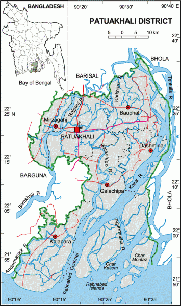
Patuakhali District (Barisal division) with on area of 3221.31 sq km, is bounded by Barisal district on the north, the Bay of Bengal on the south, Bhola district on the east, Barguna district on the west. The area of the district is composed of some small chars or islands. Maximum temperature 33.3°C and minimum 12.1°C; annual rainfall 2506 mm. Main rivers are the Andharmanik, Agunmukha, Payra, Lohalia, Patuakhali and Tentulia. The region having been close to the sea, frequently falls victim to tornado and tidal bore.
The location of Patuakhali town is 22.3592446N 90.3299868E. Patuakhali (Town) consists of 9 wards and 29 mahallas. The area of the town is 5.81 sq km. It has a population of 62439; male 53.68%, female 46.32%. The density of population is 10747 per sq km. The literacy rate among the town people is 61.6%. The town has one dakbungalow.
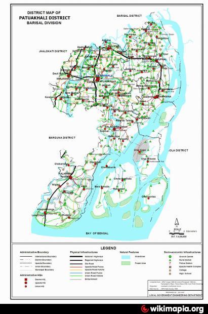
Patuakhali a coastal zila, a sub-division of Barisal zila Region which is situated at the fringe of the Bay of Bengal. It became a sub-division in 1871 and a zila in December, 1969. Patuakhali was upgraded to a zila on December 1,1983. It consists of 6 upazilas, 3 municipalties, 27 wards, 61 mahallas, 67 union parishads, 566 mouzas and 882 villages. The upazilas are bauphal, dashmina, galachipa, kalapara, mirzaganj and patuakhali Sadar.
Archaeological heritage: Gurinda Masjid at Ratandi, Sreerampur Mian Bari Mosque, Talukdar Bari Jami Mosque (Dashmina), Betagi Sikdaria Jami Mosque, Dighi of Kaviray-bari (Dashmina), Kuakata Buddist Vihara, Kapradanga Buddhist Math, Mistri-para Buddist Vihara (Kalapara), Mosque of Ghaseti Begum (1757) at village Shaula, Pakdal Mian Bari Masjid, Bauphal Central Kalibari Mandir (1875), Tomb of Syed Arefin at Kalisuri, Ashram of Mahendra Pagla, Dargah of Tamir at Kalaya, Mitha Pukur (pond) at Daspara, Tomb of Sultan Fakir at Baufal, Shahi Mosque at Masjidbaria of Mirzaganj.
Historical events: The area constituting Patuakhali district had been included within the ancient kingdom of chandradvipa. Due to natural calamities on the coastal areas and the frequent Partuguese and Magh raids the capital was transferred to Madhabpasha in Barisal. Mughal emperor Akbar, sent kanungo Jimmak Khan to Chandradvipa in 1599 to survey the area. The forest area of Chandradvipa was separated from Chandradvipa and marked as 'bazuha` or protected region. Three parganas such as Selimabad, Buzurg Umedpur and Aurangpur were then constituted in this region. In the last quarter of the eighteenth century huge number of Buddhist Rakhains of Arakan escaped the atrocities of the Burmese king and settled at Rangabali Island of Galachipa upazila, Khepupara and Kuakata in Kalapara upazila.
As of the 1991 Bangladesh census: Population 15,96,222; male 50.01%, female 49.99%; Muslim 91.45%, Hindu 8.39%, Buddhist 0.13%, Christian 0.03%; ethnic nationals: Rakhains 13300. Density of population per sq km is 397.
Religious institutions: Mosques 3892, temples 187, Buddhist temples 3, church 3, Buddhist vihara 28, pagoda 5, dargah 3, mazar 9.
Literacy and educational institutions: Average literacy 36.4%; male 42.7%, female 30%. Educational institutions: college (government) 2, (non-government) 24, science and technology university 1, teacher's training college 2, high school (government) 2, (non-government) 225, junior high school 37, madrasa 300, primary school 1150, primary training institute 1, polytechnic institute 1, nursing institute 1, vocational training institute 3, community school 10, satellite school 15, kindergarten 4.
Cultural institutions: Club 195, organisation 110, co operative society 457, women's association 33, public library 11, press club 2, artist and theatre party 10, community centre 22, cinema hall 18.
Main occupations: Agriculture 45.84%, fishing 3.32%, commerce 9.94%, service 6.12%, agricultural labourer 16.72%, wage labourer 4.53%, construction 1.31%, others 12.22%.
Land use: Cultivable land 222899 hectares, fallow land 3694 hectares; single crop 59.02%, double crop 37% and triple crop land 3.98%. Cultivable land under irrigation 3.8%
Land control: Among the peasants, 30% are landless, 24% small peasant, 41% intermediate and 5% rich; cultivable land per head 0.174 hectare.
Fisheries, dairies and poultries Fishery 144, shrimp 53, livestock 30, poultry 103, hatchery 2, fish nursery 1.
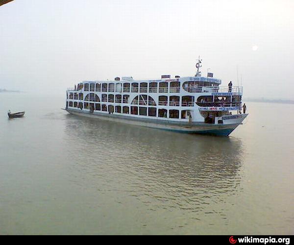
Communication facilities- Roads: pucca and semi pucca 417 km and mud road 5341 km, waterways 224 nautical mile.
Manufactories: Textile mill 1, jute mill 1, ice mill 39, rice mill 380, saw mill 80, flour mill 6.
Cottage industries: include jute work, weaving, welding, workshop, carpentry, bamboo and cane work, mat making, goldsmith, blacksmith, pottery, tailoring, craftsmanship.
NGO activities: Operationally important NGOs are brac, proshika, asa, CARE, CODEC, Terry-des-Homes, DANIDA, Urban, SAP Bangladesh, caritas, CIKODA, Solve, Sound, VOSD, CDS, SCI, BDC, RDS, ISWA, BAOPA, CEP, BARD, SNOB, PDO, CSDP, Yubak, Sangkalpa, CALB, Mauchak, Anirban, Mahila Sangstha, Adarsha Mahila Sangstha, Palli Seba Sangha.
Health centres: Zila health centre 1, hospital 4, NGO operated hospital and health centre 2, upazila health complex 6, satellite clinic 19, chest diseases clinic 1, mother and child care centre 1, child care centre 4, family health centre 1, family planning centre 40, private clinic 10, community clinic (proposed) 175.
Patuakhali district is called "SagorKonna", which means "Daughter of Sea". It is watered by the Bay of Bengal.
The three sides of Patuakhali city is surrounded by rivers. Among them two major rivers are Laukathi and Lohalia, which are directly connected with the Bay of Bengal.
The town also has a inland airstrip for emergency use.
There is a popular beach in this district at Kuakata, offering decent views of the Bay of Bengal. A number of different tribal peoples live in the district.
The location of Patuakhali town is 22.3592446N 90.3299868E. Patuakhali (Town) consists of 9 wards and 29 mahallas. The area of the town is 5.81 sq km. It has a population of 62439; male 53.68%, female 46.32%. The density of population is 10747 per sq km. The literacy rate among the town people is 61.6%. The town has one dakbungalow.
Patuakhali a coastal zila, a sub-division of Barisal zila Region which is situated at the fringe of the Bay of Bengal. It became a sub-division in 1871 and a zila in December, 1969. Patuakhali was upgraded to a zila on December 1,1983. It consists of 6 upazilas, 3 municipalties, 27 wards, 61 mahallas, 67 union parishads, 566 mouzas and 882 villages. The upazilas are bauphal, dashmina, galachipa, kalapara, mirzaganj and patuakhali Sadar.
Archaeological heritage: Gurinda Masjid at Ratandi, Sreerampur Mian Bari Mosque, Talukdar Bari Jami Mosque (Dashmina), Betagi Sikdaria Jami Mosque, Dighi of Kaviray-bari (Dashmina), Kuakata Buddist Vihara, Kapradanga Buddhist Math, Mistri-para Buddist Vihara (Kalapara), Mosque of Ghaseti Begum (1757) at village Shaula, Pakdal Mian Bari Masjid, Bauphal Central Kalibari Mandir (1875), Tomb of Syed Arefin at Kalisuri, Ashram of Mahendra Pagla, Dargah of Tamir at Kalaya, Mitha Pukur (pond) at Daspara, Tomb of Sultan Fakir at Baufal, Shahi Mosque at Masjidbaria of Mirzaganj.
Historical events: The area constituting Patuakhali district had been included within the ancient kingdom of chandradvipa. Due to natural calamities on the coastal areas and the frequent Partuguese and Magh raids the capital was transferred to Madhabpasha in Barisal. Mughal emperor Akbar, sent kanungo Jimmak Khan to Chandradvipa in 1599 to survey the area. The forest area of Chandradvipa was separated from Chandradvipa and marked as 'bazuha` or protected region. Three parganas such as Selimabad, Buzurg Umedpur and Aurangpur were then constituted in this region. In the last quarter of the eighteenth century huge number of Buddhist Rakhains of Arakan escaped the atrocities of the Burmese king and settled at Rangabali Island of Galachipa upazila, Khepupara and Kuakata in Kalapara upazila.
As of the 1991 Bangladesh census: Population 15,96,222; male 50.01%, female 49.99%; Muslim 91.45%, Hindu 8.39%, Buddhist 0.13%, Christian 0.03%; ethnic nationals: Rakhains 13300. Density of population per sq km is 397.
Religious institutions: Mosques 3892, temples 187, Buddhist temples 3, church 3, Buddhist vihara 28, pagoda 5, dargah 3, mazar 9.
Literacy and educational institutions: Average literacy 36.4%; male 42.7%, female 30%. Educational institutions: college (government) 2, (non-government) 24, science and technology university 1, teacher's training college 2, high school (government) 2, (non-government) 225, junior high school 37, madrasa 300, primary school 1150, primary training institute 1, polytechnic institute 1, nursing institute 1, vocational training institute 3, community school 10, satellite school 15, kindergarten 4.
Cultural institutions: Club 195, organisation 110, co operative society 457, women's association 33, public library 11, press club 2, artist and theatre party 10, community centre 22, cinema hall 18.
Main occupations: Agriculture 45.84%, fishing 3.32%, commerce 9.94%, service 6.12%, agricultural labourer 16.72%, wage labourer 4.53%, construction 1.31%, others 12.22%.
Land use: Cultivable land 222899 hectares, fallow land 3694 hectares; single crop 59.02%, double crop 37% and triple crop land 3.98%. Cultivable land under irrigation 3.8%
Land control: Among the peasants, 30% are landless, 24% small peasant, 41% intermediate and 5% rich; cultivable land per head 0.174 hectare.
Fisheries, dairies and poultries Fishery 144, shrimp 53, livestock 30, poultry 103, hatchery 2, fish nursery 1.
Communication facilities- Roads: pucca and semi pucca 417 km and mud road 5341 km, waterways 224 nautical mile.
Manufactories: Textile mill 1, jute mill 1, ice mill 39, rice mill 380, saw mill 80, flour mill 6.
Cottage industries: include jute work, weaving, welding, workshop, carpentry, bamboo and cane work, mat making, goldsmith, blacksmith, pottery, tailoring, craftsmanship.
NGO activities: Operationally important NGOs are brac, proshika, asa, CARE, CODEC, Terry-des-Homes, DANIDA, Urban, SAP Bangladesh, caritas, CIKODA, Solve, Sound, VOSD, CDS, SCI, BDC, RDS, ISWA, BAOPA, CEP, BARD, SNOB, PDO, CSDP, Yubak, Sangkalpa, CALB, Mauchak, Anirban, Mahila Sangstha, Adarsha Mahila Sangstha, Palli Seba Sangha.
Health centres: Zila health centre 1, hospital 4, NGO operated hospital and health centre 2, upazila health complex 6, satellite clinic 19, chest diseases clinic 1, mother and child care centre 1, child care centre 4, family health centre 1, family planning centre 40, private clinic 10, community clinic (proposed) 175.
Patuakhali district is called "SagorKonna", which means "Daughter of Sea". It is watered by the Bay of Bengal.
The three sides of Patuakhali city is surrounded by rivers. Among them two major rivers are Laukathi and Lohalia, which are directly connected with the Bay of Bengal.
The town also has a inland airstrip for emergency use.
There is a popular beach in this district at Kuakata, offering decent views of the Bay of Bengal. A number of different tribal peoples live in the district.
Nearby cities:
Coordinates: 22°21'27"N 90°19'40"E
- Bhola District Town 49 km
- Feni 135 km
- Khagrachari District 209 km
- Narsingdi District 212 km
- Rangamati District 231 km
- Habigonj District 283 km
- Maulvibazar District 301 km
- Sunamganj District 324 km
- Sylhet District 341 km
- Jiuzhaigou County 1804 km
- Barishal Division 11 km
- Mirzaganj Upazila HQ 12 km
- Dumki Upazila HQ 12 km
- ভরপাশা ইউনিয়ন 15 km
- Betagi Upazila HQ 17 km
- Kathalia Upazila HQ 21 km
- Bamna Upazila HQ 26 km
- Bhandaria Upazila HQ 32 km
- Zianagar Upazila 41 km
- Khulna Division 119 km
Comments