Bhandaria Upazila HQ
| township, subdistrict, fourth-level administrative division, local government
Bangladesh /
Pirojpur /
Bhandaria /
World
/ Bangladesh
/ Pirojpur
/ Bhandaria
township, subdistrict, fourth-level administrative division, local government
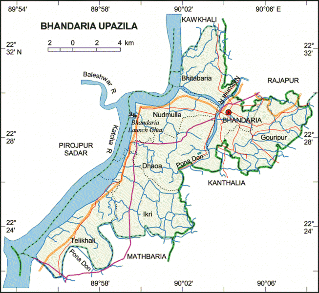
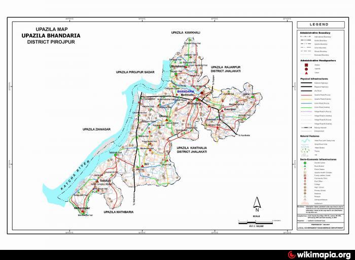
Bhandaria Upazila (Pirojpur district) with an area of 133.56 sq km is bounded by rajapur and Kawkhali upazilas on the north, Mathbaria upazila on the south, Kathalia upazila on the east and Pirojpur sadar upazila on the west. Main rivers are Katcha and Nalburia.
The location of the Bhandaria town is 22.4889°N 90.0733°E. Bhandaria Upazila (pirojpur district) with an area of 133.56 sq km is bounded by rajapur and kawkhali upazilas on the north, mathbaria upazila on the south, kathalia upazila on the east and pirojpur sadar upazila on the west. Main rivers are Katcha and Nalburia.
Bhandaria (Town) consists of 3 mouzas. The area of the town is 9.74 sq km. It has a population of 21479; male 51.92%, female 48.08%. Literacy rate among the town people is 65.2%. The town has one dakbungalow.
Bhandaria thana, now an upazila, was established in 1856. It consists of 7 union parishads, 37 mouzas and 37 villages.
Historical events: Peasant rebellion was held at Singkhali in 1847; peasant leader Gagan and Mohan Miah led the rebellion.
As of the 1991 Bangladesh census, Population 145233; male 50.34%, female 49.66%; Muslim 88.45%, Hindu 11.54% and others 0.01%.
Religious institutions Mosque 660, temple 172.
Literacy and educational institutions Average literacy 54.4%; male 61.6% and female 47.1%. Educational institutions: college 3, high school 19, junior school 8, madrasa 72, government primary school 97, non-government primary school 19. Notable institution: Bhandaria Bihari Secondary School (1913).
Main occupations Agriculture 31.51%, agricultural labourer 15.58%, wage labourer 7.29%, commerce 15.65%, service 8.56%, fishing 4.78%, construction 1.11%, transport 1.9 and others 13.62%.
Land use: Cultivable land 520.53 hectares, fallow land 2107.65 hectares; single crop 42%, double crop 52% and treble crop 6%.
Land control: Among the peasants 27.22% are landless, 30.65% marginal, 23.32% small, 18.26% intermediate and 0.55% rich.
Fisheries, dairies, poultries Poultry 116, dairy 179, nursery 12 and fishery 1824.
Communication facilities Roads: pucca 46 km, semi pucca 33 km and mud road 350 km; waterways 39 nautical mile.
NGO activities Operationally important NGOs are brac, CARE, caritas, asa.
Health centres Upazila health complex 1, family planning centre 8, satellite clinic 7.
Nearby cities:
Coordinates: 22°29'8"N 90°3'14"E
- Lohajang Upazila 119 km
- Matlab Upazila (North) Area 125 km
- Keraniganj Upazila 142 km
- Rupganj Upazila 171 km
- Patiya Upazila (পটিয়া) 180 km
- Banshkhali Upazila (বাঁশখালী উপজেলা) 188 km
- Chandanaish Upazila 196 km
- Kapashia Upazila 203 km
- Gafargaon Upazila 233 km
- Dhobaura Upazila 303 km
- Zianagar Upazila 11 km
- Pirojpur District Town 12 km
- CHAITA GARAM-----YOUNUS REZA 22 km
- Rumpur Village----------------younus reza 23 km
- KRISHNAKATHI 27 km
- ভরপাশা ইউনিয়ন 28 km
- DUDHALMOW 29 km
- Barishal Division 31 km
- Patuakhali Dist Town 32 km
- Khulna Division 87 km