Grave Circle B, Mycenae
| archaeological site
Greece /
Argolis /
Koutsopydion /
World
/ Greece
/ Argolis
/ Koutsopydion
, 6 km from center (Κουτσοπόδιον)
World / Greece / Peloponnisos
archaeological site
Add category

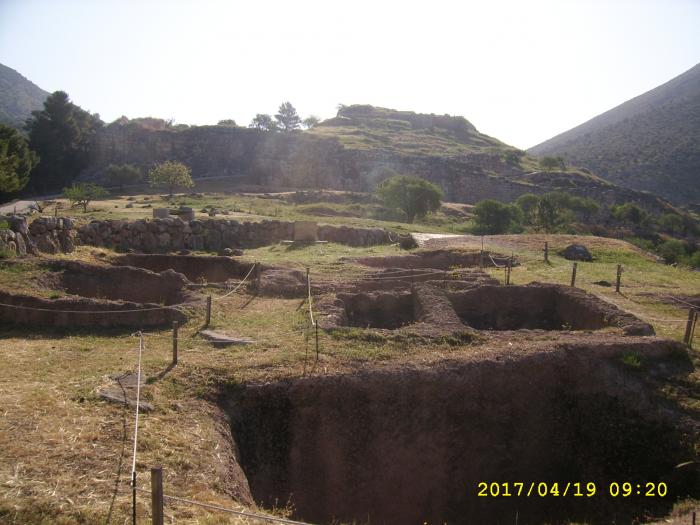

The cemetery known as "Grave Circle B" is located outside the fortified perimeter of the Bronze-Age acropolis of Mycenae. It contains the earliest set of royal or aristocratic burials at the site, and has been dated to the late 17th/early 16th century BC (this makes Grave Circle B older than Grave Circle A, which is located within the citadel to its east). Grave Circle B includes 10 cist graves and 14 shaft graves; the former were earlier and simpler in construction, the latter were later, deeper, richer, and often contained more than one burial. The graves were eventually enclosed within a low circular stone wall some 28 meters in diameter. The site has been damaged over time, with the later Bronze Age tholos "Tomb of Klytaimnestra" overlapping the grave circle from the east and the modern road encroaching from the west and north.
Some additional archaeological information: www.odysseyadventures.ca/articles/mycenae/article_mycen...
Some additional archaeological information: www.odysseyadventures.ca/articles/mycenae/article_mycen...
Wikipedia article: http://en.wikipedia.org/wiki/Grave_Circle_B,_Mycenae
Nearby cities:
Coordinates: 37°43'50"N 22°45'17"E
- Mycenae 0.3 km
- Archaia Nemea 10 km
- Acropolis 11 km
- Ancient city of Kleonai 11 km
- Acrocorinth 21 km
- The Harbor of Lechaion 25 km
- Archaeological Site of Isthmia 29 km
- The Fortress and the Hexamilion 29 km
- Diolkos Corinth (Railway) 30 km
- Leuktra (Leuctra) 69 km
- Mycenaean Tombs 0.8 km
- Σάρα 1.5 km
- Αγιολιάς - Mount Profitis Ilias (804 m) 1.7 km
- Restaurant. 2 km
- Mycenaean Road 3.8 km
- Argos Moto Cross Park 4.8 km
- Derbenaki Pass 6.8 km
- Parnavos 9 km
- Peripheral unit of Corinthia 22 km
- Peripheral unit of Argolis 23 km