Dallas Executive Airport (RBD/KRBD) (Dallas, Texas)
USA /
Texas /
Duncanville /
Dallas, Texas
World
/ USA
/ Texas
/ Duncanville
World / United States / Texas
airport
Add category
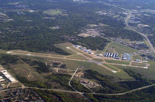
Formerly known as Red Bird Airport, (Red Bird being a common traditional name for public facilities in the area around the intersection of Loop 12 Walton Walker and U.S. Hwy 67 Marvin D. Love.) One of two airports operated by the City of Dallas (Love Field is the other) Dallas obtained the property for Red Bird Airport in 1945, and the facility has been in continuous operation since then. In the 1970's the field was the major Dallas base for the Houston-based Goodyear blimp and its recovery and service crews on their many promotional stops in the Metroplex. In the 1980's the field also became home to the Dallas Police Department's Aviation Division, housing the department's fleet of helicopters. In addition the field has also been home to several aircraft customization facilities, including one affiliated with Lear-Jet.
As part of its rechristening as Dallas Executive Airport the field has recently undergone major renovation as well as new construction, including the building of a new, more advanced control tower.
Official Website: www.dallascityhall.com/html/dallas_executive_airport.ht...
Airport Information: www.airnav.com/airport/KRBD
www.txdot.gov/publications/aviation/directory/rbd.pdf
Wikipedia article: http://en.wikipedia.org/wiki/Dallas_Executive_Airport
Nearby cities:
Coordinates: 32°40'52"N 96°52'11"W
- Dallas-Fort Worth International Airport (DFW/KDFW) 38 km
- Naval Air Station Fort Worth Joint Reserve Base (KNFW/FWH) 57 km
- Sheppard Air Force Base/Wichita Falls Municipal Airport (SPS/KSPS) 214 km
- Abilene Regional Airport 267 km
- Dyess Air Force Base (DYS/KDYS) 282 km
- Tinker Air Force Base (TIK/KTIK) 311 km
- Will Rogers World Airport (OKC/KOKC) 312 km
- Altus Air Force Base (LTS/KLTS ) 317 km
- The Oklahoma Spaceport - Clinton-Sherman Industrial Airpark (CSM/KCSM) 369 km
- Vance Air Force Base (END/KEND) 421 km
- Redbird 1.8 km
- Oak Cliff 2.3 km
- Cedar Forest 4.4 km
- Ledbetter Hills 4.9 km
- Camp Wisdom - BSA and Cub Scout camp 6.2 km
- The Woods 9 km
- Mountain Creek Lake Park 9 km
- Mountain Creek Lake 9 km
- High Pointe 10 km
- Dallas County, Texas 13 km