Interstate 95/495 Exit 177 (Alexandria, Virginia)
USA /
Virginia /
Huntington /
Alexandria, Virginia
World
/ USA
/ Virginia
/ Huntington
World / United States / Virginia
invisible, highway interchange / exit
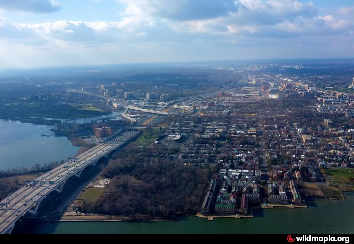
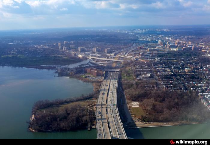
This is a free-flowing system interchange between Interstate 95/495 (the Capital Beltway) and U.S. Route 1 (Richmond Highway), located located just south of Alexandria, Virginia immediately west of the Woodrow Wilson Bridge. The interchange has nearly three levels and is partially over Hunting Creek. It was substantially reconstructed during the Woodrow Wilson Bridge Project. The interchange is fundamentally a 3-loop cloverleaf with the US-1 North to I-95 South loop replaced with a turbine-style flyover. All loops are braided to eliminate weaving. US-1 can enter both the local and express lanes from most directions, but all exits to US-1 are from the local lanes on the interstate. The interchange also provides a single exit-only from southbound I-95/495 to Washington Street (the George Washington Memorial Parkway). Additionally, there are flyovers within the interchange connecting Eisenhower Avenue to the I-95/495 express lanes in the Maryland direction only.
Prior to the Woodrow Wilson Bridge reconstruction project in the 2000s, this interchange was formerly a cloverleaf interchange with a collector-distributor roadway along southbound I-95 & I-495 (the Beltway's inner loop) and a semi-directional flyover ramp from southbound US-1 to northbound I-95 & I-495 (the Beltway's outer loop) towards the Wilson Bridge and Maryland. The interchange first opened partially in December 1961 along with a portion of the Beltway between there and Exit 3 in Maryland (MD-210/Indian Head Hwy), which included the Woodrow Wilson Bridge. When the Beltway fully opened in August 1964, the interchange's missing movements opened.
Starting in the mid-2000s, during the Wilson Bridge reconstruction project, the interchange was somewhat altered over the course of its reconstruction to its larger present-day configuration.
*In 2005, the ramp from southbound US-1 to southbound I-95 & I-495 (inner loop) branched from the left-hand side instead of the right-hand side closer to the loop ramp from southbound I-95 & I-495 (inner loop) to southbound US-1 (Exit 177A).
*With the present-day ramp from northbound I-95 & I-495 (outer loop) to US 1 constructed, including the bridges of the local lanes, the movement to southbound US-1 (Exit 177A) led directly into Old Richmond Hwy and the movement to northbound US-1 (Exit 177B) became a signalized left turn at the then-existing bridge of US-1 over the Beltway before the current free-flowing loop ramp was constructed in 2007
*As the Beltway was temporarily relocated to the current location of the outer loop local and express lanes at the Washington Street overpass with the current ramp from northbound US-1 to northbound I-95 & I-495 (outer loop) constructed, the Exit 177C ramp from southbound I-95 & I-495 (inner loop) to Mt. Vernon was closed.
*In 2006, the current flyover loop ramp from southbound US-1 to northbound I-95 & I-495 (outer loop) was constructed
*The movement from northbound US-1 to southbound I-95 & I-495 (inner loop) temporarily became a signalized left turn connecting to a separate ramp from that leading to northbound I-95 & I-495 (outer loop) while the current overpass of US-1 over I-95 & I-495 was being constructed, which opened in 2007 along with the current semi-directional flyover ramp from northbound US-1 to southbound I-95 & I-495 (inner loop).
By December 2008, the current interchange was completed.
Destinations:
Interstate 95 South/495 West- Richmond, To VA-241
Interstate 95 North/495 East- Baltimore, To I-295
U.S. Route 1 North- Alexandria
U.S. Route 1 South- Fort Belvoir
Washington Street- To George Washington Memorial Parkway, Mount Vernon
Eisenhower Avenue via Mill Road
Wikipedia article: http://en.wikipedia.org/wiki/Interstate_95_in_Virginia#Exit_list
Nearby cities:
Coordinates: 38°47'39"N 77°3'21"W
- Bryans Road, Maryland 16 km
- Chesapeake Beach Railroad 17 km
- NSWC Dahlgren Division Downrange Impact Area 52 km
- Chesapeake Ranch Estates-Drum Point, Maryland 70 km
- Chesapeake Bay Impact Crater 139 km
- Fan Mountains 176 km
- Cobham Bay 183 km
- Chesapeake Bay Bridge Tunnel 204 km
- Hampton Roads 204 km
- Lynnhaven Bay 226 km
- Wilkes Street cemetery complex 0.7 km
- Belle Haven Country Club 0.9 km
- Old Town Alexandria 1 km
- Jones Point Park 1.3 km
- Alexandria VA flood zone 1.5 km
- Huntington, Virginia 1.5 km
- Woodrow Wilson Bridge 1.8 km
- Belle Haven, Virginia 1.9 km
- Dyke Marsh 2.7 km
- Fort Washington, Maryland 7.1 km