Pachaimalai
India /
Tamil Nadu /
Arumbavur /
World
/ India
/ Tamil Nadu
/ Arumbavur
World / India / Tamil Nadu / Perambalur
hill, forest, nature conservation park / area
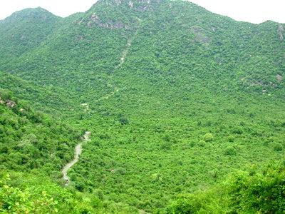
Pachaimalai, also known as the Pachais, are hills which are part of Eastern Ghats in Tamil Nadu in Trichy district. Located near 11°11′N 78°21′E / 11.18°N 78.35°E / 11.18; 78.35. Pachai in Tamil means green. They are much greener than some of the other hills in the vicinity. VeeraRamar Dam is located in these hills on Kallar.
Rivers include Kallar and Sweata Nadi. Waterfalls include Mangalam Aruvi, Koraiyar Falls and Mayil Uthu Falls. There are also indigenous tribes, such as the Malayalis, who trade some of their surplus hill produce to the towns below on the plains, trading for items not available in the hills. Jackfruit is one a popular seasonal agriculture produce from this area.
Towns in the area include: Thuraiyur, Esanai, Elambalur, Perambalur, Gangavalli, Thammampatti, Arumbavur, Malayalappatti, Thedavur and Uppiliapuram.
Districts covered are Tiruchirappalli district, Salem District and Perambalur district.
Wikipedia article: http://en.wikipedia.org/wiki/Pachaimalai_Hills
Nearby cities:
Coordinates: 11°18'50"N 78°39'6"E
- Kolli Hills 50 km
- Kalvarayan Hills 88 km
- Vathalmalai 108 km
- Palamalai R.F 120 km
- Javadi Hills ஜவ்வாது மலைத் தொடர் 135 km
- Kollegal Forest 179 km
- Mugguru Forest 183 km
- Forest 196 km
- Forest 279 km
- Forest 290 km
- Manoj kumar manoharan's home 3.4 km
- GOVINDH, (N.K.P) ILLAM 3.7 km
- Peak 980m 5.2 km
- myilavan thottam 5.6 km
- Iladapuram Big Lake 11 km
- AMMAMPALAYAM 12 km
- Thangavelu home 13 km
- Murugan Temple 15 km
- Keerambur Lake 15 km
- Palamalai R.F 19 km
Comments