Venta (Tustin, California)
USA /
California /
Tustin /
Tustin, California
World
/ USA
/ California
/ Tustin
World / United States / California
historical layer / disappeared object
Add category
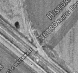
Former site of the ATSF Irvine (Venta) spur, built to serve local citrus packing houses. It left the mainline here, turned southeast at a place called Browning, and travelled through Frances (now Northwood) to Kathryn. The rails were removed in 1984.
www.trainorders.com/discussion/read.php?11,713604
ljames1.home.netcom.com/scph_orange_irvine.html
www.trainorders.com/discussion/read.php?11,713604
ljames1.home.netcom.com/scph_orange_irvine.html
Nearby cities:
Coordinates: 33°42'57"N 117°49'0"W
- The Market Place - Tustin 2.2 km
- Hines Nurseries Inc. (site) 6.2 km
- Former site of Orange County International Raceway 7.5 km
- Former home of MAG 11 ( Marine Aircraft Group 11 ) 9 km
- Former home of MAG 13 ( Marine Aircraft Group 13 ) 9 km
- Santa Ana Army Air Base (site) 10 km
- Former Ammo Dump to MCAS El Toro 11 km
- Naval Outer Landing Field, Mile Square (site) 12 km
- Preferred Pest Control 13 km
- Former location of Orange County Country Club (Santa Ana CC) 13 km
- Columbus Square 0.4 km
- Tustin Legacy (Former Marine Corps Air Station Tustin) 1.2 km
- The District at Tustin Legacy 2.2 km
- Columbus Grove Irvine 2.6 km
- Westpark II Village 2.7 km
- Edwards Lifesciences Corporation Headquarters 3.7 km
- Westpark Village 4 km
- Woodbridge Village 4.4 km
- Skypark Business Center 4.9 km
- South Coast Metro 6.2 km