Former site of Orange County International Raceway (Irvine, California)
USA /
California /
Irvine /
Irvine, California
World
/ USA
/ California
/ Irvine
World / United States / California
historical layer / disappeared object
Add category


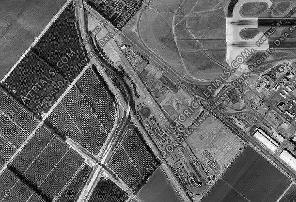
Orange County International Raceway was a combined ¼ mile drag strip and 2-mile road course located in Irvine, CA, from August 5, 1967 to October 30, 1983.
The area is now an industrial park and highway interchange.
The well-known Bob Bondurant School of High Performance Driving was founded at the track in 1968.
www.youtube.com/watch?v=jBWZHeXpil8
Wednesday night "grudge nights" were my favorites.
$5.00 for a night of drag racing my "mom's" car....those were the days! ~phiz 8/03/07
(Ren adds: I found a web site that shows the dimensions of the raceway with a key describing what is there today. Here is the link: silverstone.fortunecity.com/bonneville/218/ociraerial/ . It shows the northwest border extending up to, but not including the 1-5/133 junction, and the southeast border at Barranca. I hope the historical layer gets here soon.)
Wikipedia article: http://en.wikipedia.org/wiki/Orange_County_International_Raceway
Nearby cities:
Coordinates: 33°39'59"N 117°44'56"W
- Former home of MAG 13 ( Marine Aircraft Group 13 ) 1.2 km
- Former home of MAG 11 ( Marine Aircraft Group 11 ) 2.7 km
- Former Wherry Base Housing Area 3.5 km
- Former Ammo Dump to MCAS El Toro 5.3 km
- Hines Nurseries Inc. (site) 6 km
- The Market Place - Tustin 8.2 km
- Former location of Orange County Country Club (Santa Ana CC) 16 km
- Santa Ana Army Air Base (site) 16 km
- Preferred Pest Control 20 km
- Naval Outer Landing Field, Mile Square (site) 20 km
- Orange County, California 1.4 km
- Cypress Village 2.5 km
- Oak Creek Village 3.1 km
- Woodbury Village 3.4 km
- Baker Ranch 6.4 km
- Northwood Pointe 6.6 km
- Northpark 7.4 km
- Frank R. Bowerman Landfill 7.4 km
- Whiting Ranch Wilderness Park 8.7 km
- Limestone Canyon Regional Park 10 km
Comments