Benjamin Banneker Park (Washington, D.C.)
USA /
District of Columbia /
Washington /
Washington, D.C.
World
/ USA
/ District of Columbia
/ Washington
World / United States / District of Columbia
park
Add category
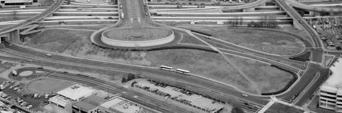
A park honoring Benjamin Banneker, an African-American who helped survey the original boundaries of the District of Columbia. The park is at the south end of L'Enfant Plaza, commemorating Peter (Pierre) Charles L'Enfant, the French-American who designed the first plan of Washington, D.C. Banneker Circle is located within the park, serving L'Enfant Plaza. The park was designed by Daniel Urban Kiley and opened in 1967. The park is managed by the National Park Service as a unit of the National Mall and Memorial Parks.
Wikipedia article: http://en.wikipedia.org/wiki/Commemorations_of_Benjamin_Banneker#Benjamin_Banneker_Park_and_Memorial,_Washington,_D.C.
Nearby cities:
Coordinates: 38°52'52"N 77°1'33"W
- East Potomac Park 0.9 km
- The National Mall 3 km
- West Potomac Park 3.2 km
- Shepherd Parkway 3.3 km
- Lady Bird Johnson Park 3.5 km
- Arlington National Cemetery 4.7 km
- Fort Totten Park 8.2 km
- Glover Parkway 8.7 km
- Chesapeake and Ohio Canal National Historical Park 10 km
- Rock Creek Park 13 km
- The Wharf 0.5 km
- Southwest Federal Center 0.5 km
- Southwest Waterfront 0.8 km
- Smithsonian Institution Campus 1 km
- Tidal Basin 1.2 km
- East Potomac Park Golf Course and Driving Range 1.3 km
- Washington Channel 1.3 km
- East Potomac Golf Blue Course 1.5 km
- Capitol Grounds 1.9 km
- Arlington County, Virginia 6.6 km
Comments