Cape Newenham Air Force Station (Site)
| military, United States Air Force, early warning radar
USA /
Alaska /
Platinum /
World
/ USA
/ Alaska
/ Platinum
World / United States / Alaska
military, United States Air Force, early warning radar

Cape Newenham Long Range Radar Site (LRRS) is a remote United States Air Force (USAF) installation situated on Cape Newenham. Cape Newenham is a small peninsula on the southwest coast of Alaska and marks the divide between Kuskokwim Bay to the north and Bristol Bay to the south. The LRRS consists of 2,359-acres and is situated across the center of the peninsula (coast to coast). Cape Newenham is located approximately 460 air miles southwest of Anchorage. The Togiak National Wildlife Refuge (formerly Cape Newenham Wildlife Refuge) occupies the rest of the peninsula along with an additional four million acres. Cape Newenham and Cape Newenham LRRS are accessible only by air or sea. The nearest community is Platinum, located 30 miles northwest on the shores of Goodnews Bay, with a population of approximately 40.
The LRRS was one of the 10 original aircraft control and warning sites constructed in Alaska as part of the establishment of a permanent air defense system. This system provided radar coverage over the segment of Alaska’s west coast. Construction of the installation was started in 1950 and was completed in 1952. Cape Newenham LRRS became operational in 1954. The installation’s early technology provided radar coverage by a radio system. The original radio system was replaced in 1957 by a White Alice Communication System (WACS), a system of Air Force-owned tropospheric scatter and microwave radio relay sites. The WACS was deactivated and replaced in 1979 with an Alascom-owned satellite communication system.
Initially, the LRRS installation provided living facilities for a permanent force of approximately 100 military personnel. In 1977, a private contractor was hired to provide support services using civilians, eliminating 80 military positions and leaving just 14 military personnel in operations at the LRRS. The station began using satellites in 1983 to relay radar data to Elmendorf Air Force Base in Anchorage, which eliminated the remaining military positions. The LRRS was converted to a Minimally Attended Radar Station (MARS, AN/FPS-117 installed) in 1986 which required even fewer personnel to reside at the installation while attending to the LRRS mission. The installation currently functions as part of the Alaska Radar System, Alaska NORAD Region, and is under the jurisdiction of the 611th Air Support Group, Elmendorf AFB and actively monitors US and North American airspace in a sector spanning from Cape Romanzof to King Salmon.
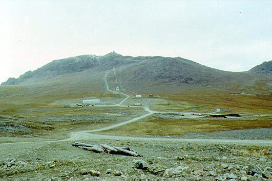
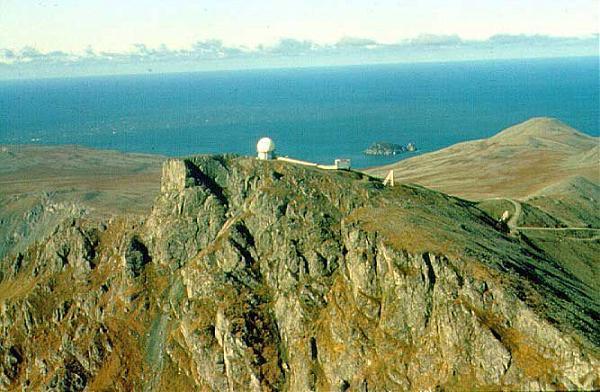
The LRRS is divided into two areas, the Upper Camp and the Lower Camp. The Upper Camp contains the radar dome facility and is connected to the Lower Camp by a road and tramway. Upper Camp is situated on a mountaintop at an elevation of approximately 2,000 feet. The Lower Camp area includes the runway, the composite building, fuel storage area, landfill, and other facilities.
www.dec.alaska.gov/spar/csp/sites/newenham.htm
www.radomes.org/cgi-bin/museum/acwinfo2x.cgi?site=%22Ca...
www.elmendorf.af.mil/news/story_print.asp?id=123131755
The LRRS was one of the 10 original aircraft control and warning sites constructed in Alaska as part of the establishment of a permanent air defense system. This system provided radar coverage over the segment of Alaska’s west coast. Construction of the installation was started in 1950 and was completed in 1952. Cape Newenham LRRS became operational in 1954. The installation’s early technology provided radar coverage by a radio system. The original radio system was replaced in 1957 by a White Alice Communication System (WACS), a system of Air Force-owned tropospheric scatter and microwave radio relay sites. The WACS was deactivated and replaced in 1979 with an Alascom-owned satellite communication system.
Initially, the LRRS installation provided living facilities for a permanent force of approximately 100 military personnel. In 1977, a private contractor was hired to provide support services using civilians, eliminating 80 military positions and leaving just 14 military personnel in operations at the LRRS. The station began using satellites in 1983 to relay radar data to Elmendorf Air Force Base in Anchorage, which eliminated the remaining military positions. The LRRS was converted to a Minimally Attended Radar Station (MARS, AN/FPS-117 installed) in 1986 which required even fewer personnel to reside at the installation while attending to the LRRS mission. The installation currently functions as part of the Alaska Radar System, Alaska NORAD Region, and is under the jurisdiction of the 611th Air Support Group, Elmendorf AFB and actively monitors US and North American airspace in a sector spanning from Cape Romanzof to King Salmon.
The LRRS is divided into two areas, the Upper Camp and the Lower Camp. The Upper Camp contains the radar dome facility and is connected to the Lower Camp by a road and tramway. Upper Camp is situated on a mountaintop at an elevation of approximately 2,000 feet. The Lower Camp area includes the runway, the composite building, fuel storage area, landfill, and other facilities.
www.dec.alaska.gov/spar/csp/sites/newenham.htm
www.radomes.org/cgi-bin/museum/acwinfo2x.cgi?site=%22Ca...
www.elmendorf.af.mil/news/story_print.asp?id=123131755
Wikipedia article: https://en.wikipedia.org/wiki/Cape_Newenham_Air_Force_Station
Nearby cities:
Coordinates: 58°38'33"N 162°3'19"W
- Fort Morrow/Port Heiden Air Force Station (Site) 273 km
- Port Moller Airport (PAAL / 1AK3) 306 km
- Cape Romanzof Airfield (CZF) 414 km
- Cape Romanzof Air Force Station 415 km
- Former Northeast Cape Air Force Station 642 km
- Port Clarence, AK LORAN Coast Guard Station 779 km
- Tin City Long Range Radar Station Tram System 831 km
- Former Tin City Air Force Station 832 km
- Ureliki 872 km
- Military airfield Uelkal Alaska-Siberia route 1175 km
- Mount Jagged 1.9 km
- Nanvak Bay 19 km
- Chagvan Bay 26 km
- Norseman Lake 38 km
- Hagemeister Island 68 km
- High Island 95 km
- Crooked Island 103 km