The (former) Berlin Wall (Berlin)
| Cold War 1947-1991, UNESCO World Heritage Site
Germany /
Berlin /
Berlin
World
/ Germany
/ Berlin
/ Berlin
World / Germany / Berlin / Berlin
Cold War 1947-1991, draw only border, UNESCO World Heritage Site


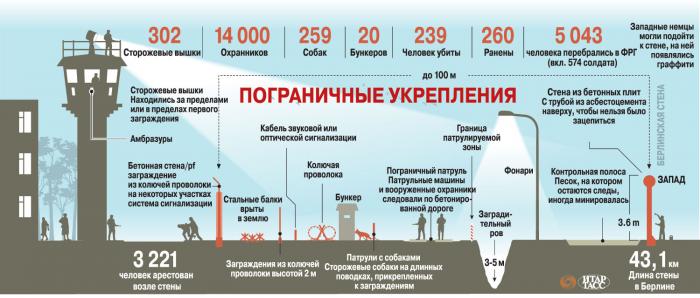
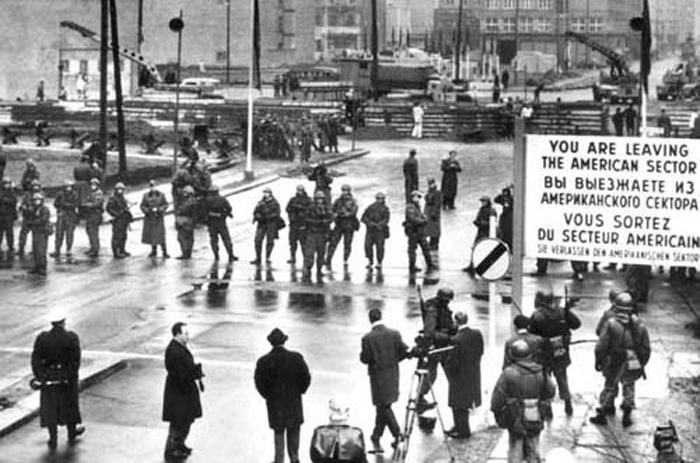
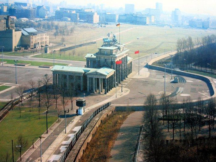
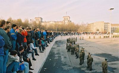

The Berlin Wall (German: Berliner Mauer) was a barrier constructed by the German Democratic Republic (GDR, East Germany) starting on 13 August 1961, that completely cut off (by land) West Berlin from surrounding East Germany and from East Berlin. The barrier included guard towers placed along large concrete walls, which circumscribed a wide area (later known as the "death strip") that contained anti-vehicle trenches, "fakir beds" and other defenses. To enter this 'strip' unauthorized meant death.
The Eastern Bloc claimed that the wall was erected to protect its population from fascist elements conspiring to prevent the "will of the people" in building a socialist state in East Germany (German: antifaschistischer Schutzwall). In practice, the Wall served to prevent the massive emigration and defection that marked Germany and the communist Eastern Bloc during the post-World War II period.Before its construction, hundreds of people fled to the West each day.
Berlin was partitioned in the same way as the rest of Germany, West-Berlin became a part of the FRG and East-Berlin became a part of the GDR. The Berlin wall was built in 1961 by the communist East German Government. The wall fell in 1989 and Germany was officially reunified in 1990. Since then most of the wall was demolished. Some ruins of the wall remain throughout the city, while remains of the wall were donated to various countries as a symbol of freedom. en.wikipedia.org/wiki/List_of_Berlin_Wall_portions
About the attached polygon.
The attached polygon delineates generally the area of the "death strip" between the two sides of the Wall as it looked in its final phase, about 6 months before the Wall fell on 9 November 1989. It shows only that part of the separation zone as it divided the City in two halves, that is from the City line where it meets the surrounding Lande of Brandenburg, both to the north and south of the City respectively.
The outer wall closest to West Berlin was called the “vordere Sperrmauer”, the width of the border strip contained its "control strip," the border patrol road, watchtowers, and the inner wall closest to East Berlin was called the “Hinterlandsicherungsmauer”. The information is sourced from this official City of Berlin website commemorating the Wall : www.berlin.de/mauer/luftbilder/1989/index.en.php
How to use the attached polygon.
First, if you want to select & open this page again, directly by clicking on the polygon on the map, this can be tricky given its length & narrowness. Easiest might be to zoom out from any point in the City all the way to level 9. Then find the large suburb of Reinickendorf to the northwest. As you scroll your cursor very slowly over the eastern border of that polygon, you should just pick up on this one,
Next, in order to view the polygon over only a small portion of its length, whilst zoomed in on a small segment of the City, it is necessary to overcome some of the existing system limitations, The easiest way to do this (assuming you are a Registered User!) is to switch to resize mode [select 'Menu'--> scroll to & select --> Resize outline (polygon)]. The points of the polygon will be picked out in red dots, whilst the enclosed area is highlighted (usually in a bright yellow shade !). You can now zoom in and explore the polygon as in effect an overlay in various parts of the City, without losing these aspects defining the polygon. You can see how the width of the 'death strip' varied and where new buildings now lie over it. Please be careful not to move the polygon points, and if you do so by accident, then just be sure to cancel the re-size mode upon leaving, rather than save any accidental changes ! Enjoy!
Wikipedia article: http://en.wikipedia.org/wiki/Berlin_Wall
Nearby cities:
Coordinates: 52°30'48"N 13°26'9"E
- Lutherstadt Wittenberg 91 km
- Lutherstadt Eisleben 170 km
- Stevns Klint 323 km
- Toruń 344 km
- Kraków 516 km
- District No. I, Stare Miasto 526 km
- Wieliczka Salt Mine 538 km
- Curonian Spit 583 km
- Sękowa 628 km
- Poloniny National Park 716 km
- Berlin Ostbahnhof 0.3 km
- Hellweg Baumarkt / DIY superstore 0.5 km
- Karl-Marx-Allee 0.5 km
- METRO Cash & Carry 0.7 km
- Comeniusplatz 0.8 km
- United Nations Square - Platz der Vereinten Nationen 1.2 km
- Friedrichshain 1.3 km
- Kreuzberg 2.6 km
- Mitte 2.8 km
- Prenzlauer Berg 2.9 km
Comments