R/P FLIP
USA /
California /
Coronado /
World
/ USA
/ California
/ Coronado
World / United States / California
research, ship
The FLIP (FLoating Instrument Platform) fulfills the scientific need for a steady platform in rolling seas. FLIP has been used for a number of studies including wave height, acoustic signals, water temperature and density, and for the collection of meteorological data.
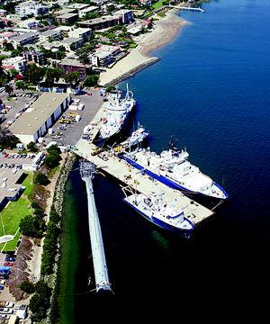
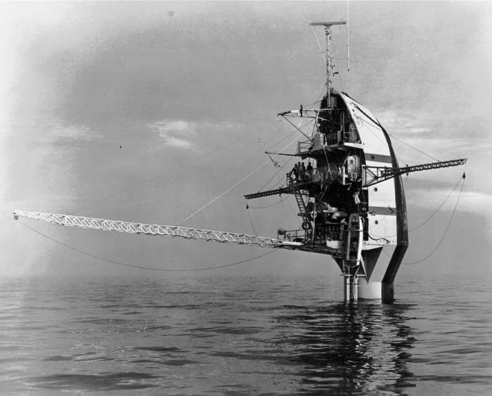
It is a 355-foot vessel that is towed in a horizontal position to the research site. When in place, the bottom three hundred feet of the vessel is flooded with 1500 tons of seawater leaving only 55 feet above the surface (see pictures of both positions on the next page). During this process, scientists and crewmembers literally walk up the walls to stay upright.
The 300 feet that stays in the stable water column provides so much stability that the vessels is almost unaffected by vertical wave motion. A 30-foot wave only causes FLIP to move 3 feet vertically in the water column.
FLIP carries a crew of five as well as eleven scientists. To date, over 300 operations using FLIP have been executed which have lasted up to 35 days.
The Marine Physical Laboratory of the Scripps Institution of Oceanography created FLIP with funding from the Office of Naval Research (TRF).
The Gunderson Brothers Engineering Company in Portland, Oregon launched FLIP in June 1962.
It has the ability to drift freely or be moored and also has the ability to operate in deep or shallow water.
All of the instrumentation is hinged so scientist and operator can function on FLIP in the vertical or horizontal position. Three anchors are used for mooring and can more in water with depths of 2,000 fathoms or deeper. Although it was designed to operate in waves up to thirty feet, it has withstood 80-foot swells.
In 1987, FLIP was moored in 2400-fathom water. With a 30-knot wind, FLIP only moved in a 200-meter diameter.
In 1995, FLIP received a $2,000,000 modernization. The structural build is currently excellent and instrumentation will allow FLIP to be an oceanographic powerhouse in the future.
This is the only vessel of its kind in the world, having the ability to flip from a horizontal position to a vertical position while at sea. This type of platform is extremely valuable for oceanographers all over the world.
FLIP is 108 meters long and ways 700 long tons. In tow, it has the ability to travel at speeds from 7-10 knots. It operates worldwide but the normal operating are is the west coast of the United States. The main power source comes from two 150 KW Generators with one 40 KW generator for backup. Navigation equipment includes a Gyro, GPS, and RADAR. Communication equipment includes HF, VHF, INMARSAT, and cellular. There are a number of booms and winches that are used for deploying scientific equipment.
Wikipedia article: http://en.wikipedia.org/wiki/RP_FLIP
Nearby cities:
Coordinates: 32°42'22"N 117°14'10"W
- Wreck of USS Independence (CVL-22) 756 km
- Lake Oroville Marina 868 km
- Naval Submarine Base Bangor 1740 km
- Montague Harbour 1874 km
- ESCO Marine Inc. 2064 km
- International Shipbreaking Limited 2065 km
- SEAFAC Static Site surface barges 2785 km
- Battleship Row 4202 km
- Wreck of USS Nevada (BB-36) 4311 km
- Wreck of USS Belleau Wood (LHA-3) 4359 km
- Defense Fuel Supply Point, Point Loma 0.7 km
- Peninsula 0.7 km
- Naval Base Point Loma 2.3 km
- Point Loma / Fort Rosecrans (former) 2.3 km
- Naval Air Station North Island 3.1 km
- Liberty Station 3.8 km
- Sea N' Air Golf Course 4.1 km
- San Diego International Airport (SAN/KSAN) 5.2 km
- Midway-Pacific Highway Corridor 5.6 km
- San Diego Bay 7.8 km
Comments