Kishorgonj District Town
Bangladesh /
Kishorganj /
World
/ Bangladesh
/ Kishorganj
/ Kishorganj
World / Bangladesh / Dhaka / Kishoreganj / Kishoreganj
city, third-level administrative division, town district
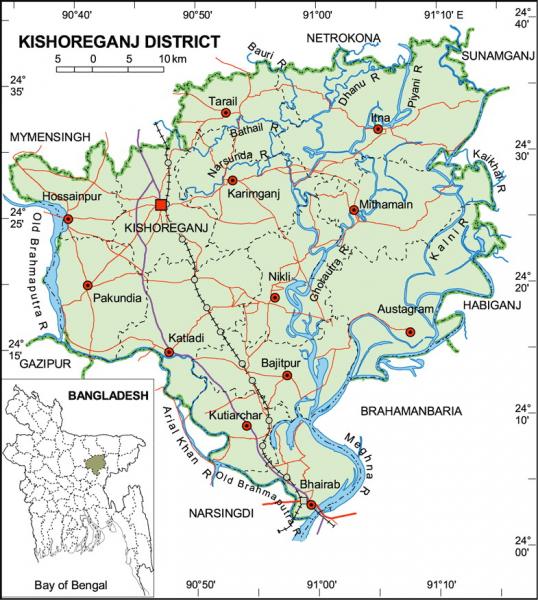
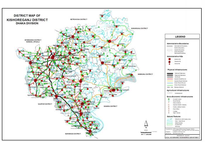
Kishoreganj District (Dhaka division) with an area of 2688.62 sq km, is bounded by Netrokona and Mymensingh districts on the north, Narsingdi district on the southwest and Brahmanbaria district on the southeast, Sunamganj and habiganj districts on the east, Gazipur and Mymensingh districts on the west. The soil formation of the district is alluvial sand coming from Brahmaputra, Meghna and other small rivers. The soil is fertile. Annual average temperature- maximum 33.3°C, minimum 12°C; annual rainfall 2174 mm. There are hills and hillocks on the northern and depressions on southern parts of the district. Main rivers are old Brahmaputra, meghna, Kalni, Dhanu, Ghorautra, Baurii, Narasunda, Piyain; main depressions: Humaipur (Bajitpur), Somai (Nikli), Barir (Mithamain), Surma Baula (Nikli), and Tallar Haors (Nikli-Bajitpur-Austagram).
Administration Kishoreganj district was established in 1984; earlier it was a subdivision under the Mymensingh district. The subdivision was established in 1860. The district consists of four municipalities, 39 wards, 145 mahallas, 13 upazilas, 105 union parishads, 946 mouzas and 1775 villages. The upazilas are austagram, bajitpur, bhairab, hossainpur, itna, karimganj, katiadi, kishoreganj sadar, kuliarchar, mithamain, nikli, pakundia and Tarail; municipalities are Kishoreganj Sadar, Bajitpur, Bhairab and Kuliarchar.
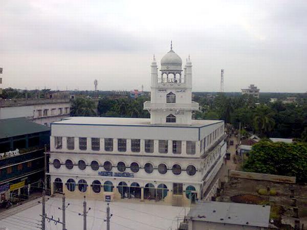
Archaeological heritage and relics: jangalbari fort (fifteenth century), egarasindhur fort (fifteenth century), sadi mosque (1652), Salanka Jame Mosque at Pakundia, Gurai Mosque at Bajitpur (1680), Kutub Shah Mosque at Austagram (1538), Jawar Saheb Bari Mosque at Tarail (1534), Badshahi Mosque at Itna (seventeenth century), Bhagalpur Dewan Bari Mosque at Bajitpur (eighteenth century), Sekandarnagar Mosque at Tarail (eighteenth century), Hazrat Samsuddin Bokhari Mosque Kurikhai at Katiadi (1005), Chandrabati Shiva Mondir (sixteenth century), Arabic stone inscription discovered at village Ghagra.
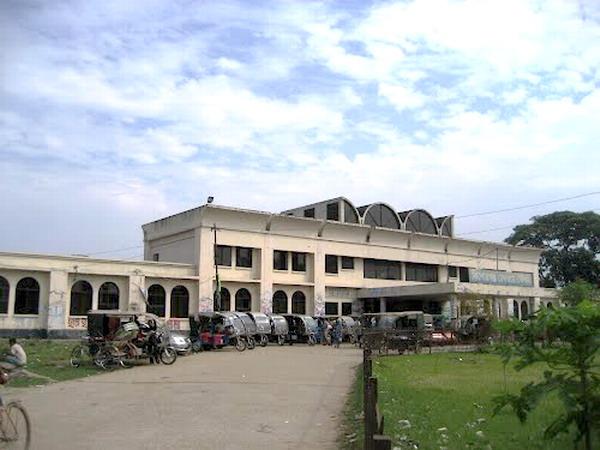
Kishoreganj (Town) located at 24.4358442N 90.7724762E degree, consists of 9 wards and 56 mahallas. Kishoreganj municipality was established in 1869. The area of the town is 19.57 sq km. It has a population of 77165; male 52.51%, female 47.49%. The density of population is 3943 per sq km. Literacy rate among the town people is 59%. It has two dakbungalows.
Historical events: In the ancient time Kishoreganj area was included in the kingdom of the Kamrupa. In the 11th and 12th century the Pala, Varman and Sena kings ruled this area or part of it. There after arose petty independent kingdoms under the Koch, Hajong, Garo and Rajbanshi. In 1491 AD, the greater part of Mymensingh was included within the Muslim rule under Firoz Shah, Kishoreganj remained outside. Greater part of Kishoreganj was included in the Mughal Empire during the rein of the Mughal Emperor Akbar. But some areas including Jangalbari and Egarasindhur remained under the Koch and Ahom kings. In 1538 AD the Ahom king of Egarasindhur was defeated by the Mughals and in 1580 the Koch Chief of Jangalbari was defeated by Isa khan. The episode of the conflict between the Mughal Commander Man Singh and Isa Khan, the Chief of the Baro-bhuiyans in 1580 and the defeat of Man Singh at Egarasindhur are still current. Though after the death of Isa Khan in 1599 the grater part of Kishoreganj was still under the rule of his son musa khan, ultimately seceded to the Mughals.
As of 1991 Bangladesh census, population 2525221; male 50.29%, female 49.71%; Muslim 92.1%, Hindu 7.2% and others 0.7%.
Religious institutions: Mosque 1035, temple 138.
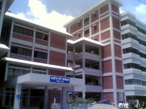
Literacy and educational institutions: Average literacy 21.94%; male 26.94% and female 16.64%. Educational institutions: medical college 1, nursing training institute 1, university (under construction) 1, college 25, collegiate high school 4, high and junior high school 201, madrasa 120, technical training institute 2, government primary school 808, non-government primary school 1137, kindergarten 16. Noted old educational institutions: Kishoreganj Boy's High School (1881), Hafez Abdur Razzaque Pilot High School, Bajitpur (1890), Jangalbari High School (1862), Mangalbaria Madrasa, Pakundia (1872), Hossainpur High School (1890), Agarpur Gokulchandra High School, Kuliarchar (1907), Kodalia High School, Pakundia (1910), Achmita George Institute (1920), Banagram High School, Katiadi (1912), Azimuddin High School, Kishoreganj (1916).
Cultural organisations: Club 240, cinema hall 23, literacy society 14, press club 1, theatre group 17, public libarary 10, women's organisation17, playground 53, theatre group 4, shishu academy 1, shilpakala academy 1.
Main occupations: Agriculture 45.48%, fishing 1.87%, agricultural labourer 21.02%, wage labourer 3.29%, commerce 11.2%, transport 2.06%, service 4.47%, others 10.61%.
Land use: Total cultivable land 187975.31 hectares, fallow land 5186.56 hectares; single crop 46.74%, double crop 39.44% and treble crop land 13.82%; land under irrigation 59.06%.
Land control: Among the peasants 16.19% are landless, 13.35% marginal, 29.42% small, 18.94% intermediate and 22.10% rich.
Main crops: Paddy, jute, wheat, mustard seed, pulse, potato, peanut, corn, sugarcane and vegetables.
Communication facilities Roads: pucca 280 km, semi pucca 210 km and mud road 5043.50; railways 57 km.
Manufactories Kalia Chapra Sugar Mill (extinct), Kishoreganj Sugar Mill (extinct), Joshodal Textile Mills, Jeminee Textile Mills, Badam Tail Mills (extinct), Aftaf Feed Mills Ltd are noted.
Cottage industries: Chess (Austagram), cane and bamboo work, iron work, wood work, etc. Maslin (Bajitpur, Jangalbari), oyster pearl (Bajitpur Astagram), paper Betal-Tatarkandi, Katiadi, Kuliarchar), tusk goods (Boulai, Kishoreganj), Shital Pati (Austagram), conch goods, etc.
NGO activities Operationally important NGOs are Care, brac, proshika, Popy, Global Village, ARA, Pallibikash.
Health centres Hospital 6, upazila health complex 13, subhealth centre 17, TB clinic 1, maternity centre 3, family welfare centre 61.
Administration Kishoreganj district was established in 1984; earlier it was a subdivision under the Mymensingh district. The subdivision was established in 1860. The district consists of four municipalities, 39 wards, 145 mahallas, 13 upazilas, 105 union parishads, 946 mouzas and 1775 villages. The upazilas are austagram, bajitpur, bhairab, hossainpur, itna, karimganj, katiadi, kishoreganj sadar, kuliarchar, mithamain, nikli, pakundia and Tarail; municipalities are Kishoreganj Sadar, Bajitpur, Bhairab and Kuliarchar.
Archaeological heritage and relics: jangalbari fort (fifteenth century), egarasindhur fort (fifteenth century), sadi mosque (1652), Salanka Jame Mosque at Pakundia, Gurai Mosque at Bajitpur (1680), Kutub Shah Mosque at Austagram (1538), Jawar Saheb Bari Mosque at Tarail (1534), Badshahi Mosque at Itna (seventeenth century), Bhagalpur Dewan Bari Mosque at Bajitpur (eighteenth century), Sekandarnagar Mosque at Tarail (eighteenth century), Hazrat Samsuddin Bokhari Mosque Kurikhai at Katiadi (1005), Chandrabati Shiva Mondir (sixteenth century), Arabic stone inscription discovered at village Ghagra.
Kishoreganj (Town) located at 24.4358442N 90.7724762E degree, consists of 9 wards and 56 mahallas. Kishoreganj municipality was established in 1869. The area of the town is 19.57 sq km. It has a population of 77165; male 52.51%, female 47.49%. The density of population is 3943 per sq km. Literacy rate among the town people is 59%. It has two dakbungalows.
Historical events: In the ancient time Kishoreganj area was included in the kingdom of the Kamrupa. In the 11th and 12th century the Pala, Varman and Sena kings ruled this area or part of it. There after arose petty independent kingdoms under the Koch, Hajong, Garo and Rajbanshi. In 1491 AD, the greater part of Mymensingh was included within the Muslim rule under Firoz Shah, Kishoreganj remained outside. Greater part of Kishoreganj was included in the Mughal Empire during the rein of the Mughal Emperor Akbar. But some areas including Jangalbari and Egarasindhur remained under the Koch and Ahom kings. In 1538 AD the Ahom king of Egarasindhur was defeated by the Mughals and in 1580 the Koch Chief of Jangalbari was defeated by Isa khan. The episode of the conflict between the Mughal Commander Man Singh and Isa Khan, the Chief of the Baro-bhuiyans in 1580 and the defeat of Man Singh at Egarasindhur are still current. Though after the death of Isa Khan in 1599 the grater part of Kishoreganj was still under the rule of his son musa khan, ultimately seceded to the Mughals.
As of 1991 Bangladesh census, population 2525221; male 50.29%, female 49.71%; Muslim 92.1%, Hindu 7.2% and others 0.7%.
Religious institutions: Mosque 1035, temple 138.
Literacy and educational institutions: Average literacy 21.94%; male 26.94% and female 16.64%. Educational institutions: medical college 1, nursing training institute 1, university (under construction) 1, college 25, collegiate high school 4, high and junior high school 201, madrasa 120, technical training institute 2, government primary school 808, non-government primary school 1137, kindergarten 16. Noted old educational institutions: Kishoreganj Boy's High School (1881), Hafez Abdur Razzaque Pilot High School, Bajitpur (1890), Jangalbari High School (1862), Mangalbaria Madrasa, Pakundia (1872), Hossainpur High School (1890), Agarpur Gokulchandra High School, Kuliarchar (1907), Kodalia High School, Pakundia (1910), Achmita George Institute (1920), Banagram High School, Katiadi (1912), Azimuddin High School, Kishoreganj (1916).
Cultural organisations: Club 240, cinema hall 23, literacy society 14, press club 1, theatre group 17, public libarary 10, women's organisation17, playground 53, theatre group 4, shishu academy 1, shilpakala academy 1.
Main occupations: Agriculture 45.48%, fishing 1.87%, agricultural labourer 21.02%, wage labourer 3.29%, commerce 11.2%, transport 2.06%, service 4.47%, others 10.61%.
Land use: Total cultivable land 187975.31 hectares, fallow land 5186.56 hectares; single crop 46.74%, double crop 39.44% and treble crop land 13.82%; land under irrigation 59.06%.
Land control: Among the peasants 16.19% are landless, 13.35% marginal, 29.42% small, 18.94% intermediate and 22.10% rich.
Main crops: Paddy, jute, wheat, mustard seed, pulse, potato, peanut, corn, sugarcane and vegetables.
Communication facilities Roads: pucca 280 km, semi pucca 210 km and mud road 5043.50; railways 57 km.
Manufactories Kalia Chapra Sugar Mill (extinct), Kishoreganj Sugar Mill (extinct), Joshodal Textile Mills, Jeminee Textile Mills, Badam Tail Mills (extinct), Aftaf Feed Mills Ltd are noted.
Cottage industries: Chess (Austagram), cane and bamboo work, iron work, wood work, etc. Maslin (Bajitpur, Jangalbari), oyster pearl (Bajitpur Astagram), paper Betal-Tatarkandi, Katiadi, Kuliarchar), tusk goods (Boulai, Kishoreganj), Shital Pati (Austagram), conch goods, etc.
NGO activities Operationally important NGOs are Care, brac, proshika, Popy, Global Village, ARA, Pallibikash.
Health centres Hospital 6, upazila health complex 13, subhealth centre 17, TB clinic 1, maternity centre 3, family welfare centre 61.
Nearby cities:
Coordinates: 24°26'12"N 90°46'52"E
- Narsingdi District 30 km
- Habigonj District 54 km
- Sunamganj District 88 km
- Maulvibazar District 93 km
- Sylhet District 119 km
- Khagrachari District 123 km
- Feni 138 km
- Rangamati District 148 km
- Bhola District Town 192 km
- Jiuzhaigou County 1607 km
- Alormela 1.4 km
- Karimganj Upazila HQ 10 km
- Madhya Para 14 km
- Achmita 18 km
- Katiadi Upazila HQ 21 km
- Mithamain Upazila HQ 28 km
- Bajitpur Upazila HQ 30 km
- Madan Upazila 32 km
- Confluence 36 km
- Dhaka Division 55 km
Comments