Landing boom
USA /
California /
Bolinas /
World
/ USA
/ California
/ Bolinas
World / United States / California
landing, crane (machine)
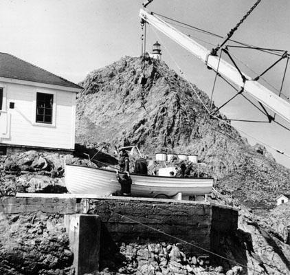

A crane-like device used to transfer people from ship to shore. Since there is no harbor or any other method of landing, this is the only way to get on the island.
Nearby cities:
Coordinates: 37°41'46"N 122°59'59"W
- Shore Hills Neighborhood, Landing, New Jersey 4126 km
- Approximate landing area of the "Lost Squadron" of 1942 5936 km
- Kon-Tiki's final destination 6307 km
- Landing Site of Apollo 12 on 24 Nov 1969 at 20:58:24 UTC 7405 km
- DZ-Y (Dropping Zone "Y") 8879 km
- LZ-S 8883 km
- DZ-X (Dropping Zone "X") 8883 km
- LZ-Z 8884 km
- Wreck of USS La Moure County (LST-1194) 9330 km
- Tok Bali Port 13277 km
- Dormitory 0.1 km
- Double Quarters 0.1 km
- Fresh Water Pump House and Cistern 0.2 km
- Catchment Basin 0.2 km
- Lighthouse Keepers' Dwellings 0.3 km
- Water Collector 0.3 km
- South Farallon Island 0.6 km
- Gerrenaldo Island 4.4 km
- US Nuclear Dump Site 5.9 km
- Farallon Islands 6.3 km