Sungai Pinang (George Town)
Malaysia /
Pulau Pinang /
Georgetown /
George Town
World
/ Malaysia
/ Pulau Pinang
/ Georgetown
neighbourhood, residential neighbourhood
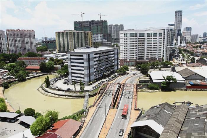
Sungai Pinang is a neighbourhood within the city centre of George Town. It lies to the south of the Sungai Pinang river, bordering Caunter Hall to the west, Jelutong suburb to the south and Bandar Sri Pinang to the east.
Due to its riverside location and flat terrain, the neighbourhood of Sungai Pinang suffers from relatively frequent flash floods. Formerly the site where Malay fishermen from Kedah had built houses long before the founding of George Town by Francis Light in 1786, Sungai Pinang has since witnessed rapid development as part of the city centre. Apartments and office blocks are now a prominent feature of the area.
Due to its riverside location and flat terrain, the neighbourhood of Sungai Pinang suffers from relatively frequent flash floods. Formerly the site where Malay fishermen from Kedah had built houses long before the founding of George Town by Francis Light in 1786, Sungai Pinang has since witnessed rapid development as part of the city centre. Apartments and office blocks are now a prominent feature of the area.
Nearby cities:
Coordinates: 5°24'13"N 100°19'21"E
- Kebun Bunga 5.5 km
- Bandar Baru Ayer Itam 5.6 km
- Sungai Nibong 6.9 km
- Seri Tanjung Pinang 6.9 km
- Bandar Bayan Baru 9 km
- Bayan Baru 10 km
- Sungai Ara 11 km
- Bandar Baru Seri Klebang 117 km
- Bandar Universiti 136 km
- kota stabat 277 km
- Pangsapuri Serendah 0.6 km
- Kampung Dodol 0.6 km
- Worksyop, Jabatan Kejuruteraan, Majlis Perbandaran Pulau Pinang 0.8 km
- Lo Pan Kong 0.8 km
- Karpal Singh Drive Promenade 1 km
- Jelutong Sewage Treatment Plant (STP) 1 km
- Jelutong 1.5 km
- Penang 7.1 km
- Penang Island 7.8 km
- Coastal waters of Penang island 7.9 km