West Bromwich
United Kingdom /
England /
West Bromwich /
World
/ United Kingdom
/ England
/ West Bromwich
World / United Kingdom / England
town, draw only border


West Bromwich (i/wɛst ˈbrɒmɪtʃ/) is a town within the Metropolitan Borough of Sandwell, itself a constituent part of the Metropolitan County of the West Midlands, England. It is 5 miles (8 km) north west of Birmingham lying on the A41 London-to-Birkenhead road. West Bromwich is part of the Black Country. Historically within Staffordshire, West Bromwich is the largest town within Sandwell, with a population of 136,940 at the time of the 2001 census. The Latin motto on the town's coat of arms (see image above)translates as "Work Conquers All".
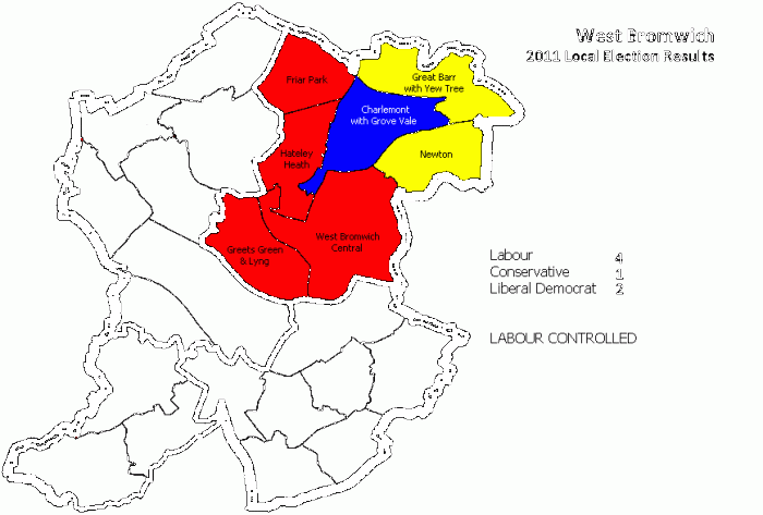
The West Bromwich urban district today comprises the following electoral wards within the Metropolitan Borough of Sandwell : Charlemont with Grove Vale, Great Barr with Yew Tree, Greets Green & Lyng, Hateley Heath, Newton & West Bromwich Central (see maps above for outline & electoral results in 2011)
The town is famous for its football club, West Bromwich Albion. The club was founded in 1878 and in 1888 it became one of the twelve founder members of the Football League. It won the league championship in 1920 and has won the FA Cup five times, most recently in 1968. The club recently won the Coca Cola Championship in 2008. Albion were based in and around the centre of West Bromwich during their formative years, but moved further out of the town in 1900 when they switched to their current ground, The Hawthorns. The Hawthorns is the highest football ground (above sea level) in the country.
West Brom is the birthplace of Robert Plant, lead singer of heavy metal band Led Zeppelin.
www.genuki.org.uk/big/eng/STS/WestBromwich/#Census
Large scale online digi-map used in drawing attached polygon is from official Sandwell MBC website see @ :
www.sandwelltrends.info/themedpages/WPSumm
Wikipedia article: http://en.wikipedia.org/wiki/West_Bromwich
Nearby cities:
Coordinates: 52°32'3"N 1°58'26"W
- Sutton Coldfield 10 km
- Walsall 12 km
- Telford 45 km
- Leicester 54 km
- Nottingham 71 km
- Metropolitan Borough of Stockport 102 km
- Warrington 111 km
- Doncaster 125 km
- Huddersfield 128 km
- York 173 km
- Sandwell Valley Country Park 0.8 km
- RSPB Sandwell Valley 1.4 km
- Hill Top Golf Club 1.6 km
- Handsworth Golf Club 2 km
- Sandwell Park Golf Club 2.1 km
- Handsworth Cemetery 2.5 km
- Sandwell 3.1 km
- Handsworth 3.7 km
- Perry Barr 4.2 km
- Ladywood 7.2 km
Comments