Hasekiyata
| urochishte (stow)
Bulgaria /
Burgas /
Malko Tarnovo /
World
/ Bulgaria
/ Burgas
/ Malko Tarnovo
, 16 km from center (Малко Търново)
urochishte (stow), invisible, draw only border
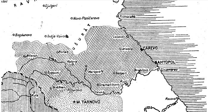
Hasekiyata is a hilly historical and geographical area in the Strandzha mountain, in the Burgas region.
The area covers a strip up to 10 km wide with a direction almost west-east, just north of the valley of the river Veleka, on the southern slopes of the Strandzha hill Bosnia. There is a hilly-plain relief, cut by the left tributaries of Veleka. Overgrown with dense deciduous forests. During the Ottoman rule, the area was privileged land.
In the Hasekia district from west to east are located the villages: Bliznak, Evrenozovo, Mladezhko, Zvezdets, Byala voda, Kalovo, Zabernovo, Gramatikovo, Kondolovo, Bulgari, Kosti, Brodilovo, Varvara and the town of Ahtopol.
Nearby cities:
Coordinates: 42°6'31"N 27°37'0"E
- "Agala" Projected new District of Burgas 51 km
- Sarlaka Locality 57 km
- Zlosten Locality 132 km
- Αlmyro 135 km
- Paliampela 135 km
- Paliochori 136 km
- Koriyata Locality 136 km
- Gushterov Bair Locality 167 km
- "The Eight" 179 km
- Gradishte Locality 206 km
- Chapel "St. Elijah" 0.4 km
- Cemetery 2.1 km
- Old Vizitsa 3.4 km
- Holy Trinity Church 3.4 km
- Tisovitsa Reserve 8.1 km
- Mount Yıldız / Strandzha 10 km
- Malko Tarnovo Municipality 10 km
- Primorsko Municipality 17 km
- Tsarevo Municipality 18 km
- Burgas Region 45 km