Footbridge (Annotto Bay)
Jamaica /
Saint Mary /
Anotto Bay /
Annotto Bay /
A4
World
/ Jamaica
/ Saint Mary
/ Anotto Bay
footbridge
Add category
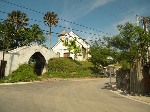
Unusual footbridge to the parish church explained by the fact that it crosses the route of the long abandoned Bog Walk to Port Antonio railway.
Photo: jm.geoview.info/annotto_bay,22472149p
Reference: UK Directorate of Overseas Surveys 1:50,000 map of Jamaica sheet K, 1966.
Online at: legacy.lib.utexas.edu/maps/americas/txu-pclmaps-oclc-11...
Photo: jm.geoview.info/annotto_bay,22472149p
Reference: UK Directorate of Overseas Surveys 1:50,000 map of Jamaica sheet K, 1966.
Online at: legacy.lib.utexas.edu/maps/americas/txu-pclmaps-oclc-11...
Wikipedia article: https://en.wikipedia.org/wiki/Bog_Walk_to_Port_Antonio_railway
Nearby cities:
Coordinates: 18°16'24"N 76°45'49"W
- Footbridge 865 km
- Walnut Street Bridge 2051 km
- T. Tyler Potterfield Memorial Bridge 2145 km
- Pedestrians and Bicycle Span 2229 km
- Louisa/Fort Gay Tri-Bridge 2281 km
- 14th Street Bridge Complex 2294 km
- Big Four Bridge 2390 km
- Big Four Bridge 2391 km
- Purple People Bridge 2436 km
- Black Tom Bridge 2509 km
- Wag Water River 2.7 km
- Fort Stewart 4.7 km
- Green Castle Estate 5.4 km
- Water Valley 6.4 km
- Jumo Pen Village 6.6 km
- Broadgate 7.3 km
- Timsberry 8.8 km
- May River 8.9 km
- Two Paths 10 km
- Grand Ridge of the Blue Mountains 16 km